


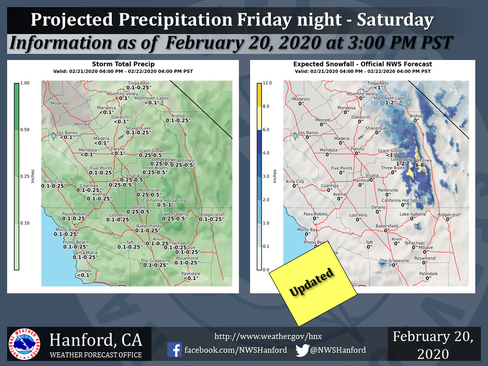
Projected Storm Totals for Mariposa, Oakhust and Yosemite Valley Less Than 0.10"
February 21, 2020 - The National Weather Service Hanford Office reports a weather system is forecast to brush the south end of the region and bring generally light rain and mountain snow to portions of the Central California Interior Friday night and Saturday.
Snow will fall above 6000 feet. Here are the latest projected rain and snowfall amounts.
  Area Forecast Discussion
  National Weather Service Hanford CA
  256 AM PST Fri Feb 21 2020

  .SYNOPSIS...Dry weather and well above normal high temperatures
  can be expected over the district today.  A storm system will
  bring showers to much of the district Friday evening through
  Saturday. Dry weather is expected Sunday through the end of
  next week along with a day to day warming trend. A return to
  unseasonably warm afternoon temperatures is likely by the
  middle of next week.

  &&

  .DISCUSSION...Our abnormally long dry spell is finally going to
  be broken over a good portion of the central California interior
  early this weekend. Unfortunately the precipitation that falls
  between Friday evening and Saturday evening will not put much of
  a dent in the existing large rain deficit so far this water year.
  It will also be the only break we get from dry weather through
  the end of February.

  The storm that will bring showers into the central California
  interior is still well offshore and currently centered roughly
  1,000 miles west of the central California coast. (33N 132W)
  Although high clouds associated with this storm will be present
  today, there will be enough sunshine to warm temperatures to
  well above normal again this afternoon. In many locations, today
  will be about as warm as yesterday.

  Meanwhile, the storm over the Eastern Pacific will continue to
  drift southward. Once this closed low gets to the latitude of
  the Channel islands, it will make a left turn toward the coast
  tonight then trek inland across southern California Saturday
  where the heaviest precipitation is likely to occur along with
  a chance of thunderstorms. Otherwise, this closed low will bring
  showers to the district tonight and Saturday. Showers will be most
  numerous over the mountains and desert.

  By the time this low exits into northwestern Arizona Saturday
  evening, there will be little more than a few residual showers
  over the mountains and desert. Precipitation totals from this
  system will be highest in the mountains of Tulare county and
  Kern county where an east to southeast flow could bring orographic
  enhancement Saturday. Elevations above 6,000 feet could pick up a
  few to several inches of snow by the time showers decrease early
  Saturday evening. Otherwise we`re not expecting any significant
  hydrological impacts from this storm system over the central
  California interior. Rain totals will range from at most a few
  hundredths of an inch in Merced county and Mariposa county to as
  much as a third of an inch south of Fresno county. Portions of
  the valley mainly north of Fresno county may not see any rain...
  at least not enough to settle the dust. Otherwise, Saturday will
  be considerably cooler than today with temperatures much closer
  to normal for a change.

  Upper level ridging will move in behind this storm system Sunday
  for a return of dry weather. This high pressure ridge will slowly
  build in over the Golden State next week and bring mostly clear
  skies along with a day to day warming trend. During the mid to
  later part of next week, thermometer readings could top the 80
  degree mark in the warmest locations of the San Joaquin Valley,
  lower foothills and the Kern county desert. However, minimum
  temperatures during this period will be seasonably chilly.
Source: NWS

