


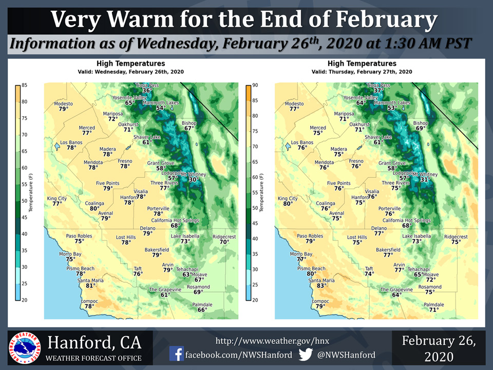
Projected high temps in the 70's for Mariposa and Oakhurst on Wednesday and Thursday
Projected high temps in the 60"s for Yosemite Valley on Wednesday and Thursday
February 26, 2020 - The National Weather Service Hanford Office reports high temperatures throughout Central California this afternoon and Thursday afternoon will generally be eleven to fourteen degrees above normal for this time of year.
Near record warmth is expected Friday afternoon, prior to a cooling trend this weekend.
  Area Forecast Discussion
  National Weather Service Hanford CA
  213 AM PST Wed Feb 26 2020

  .SYNOPSIS...
  High temperatures throughout Central California this afternoon and
  Thursday afternoon will generally be eleven to fourteen degrees
  above normal for this time of year. Maximum temperatures Friday
  afternoon will be near daily record values. A cooling trend is
  expected this weekend. An atmospheric disturbance will likely
  impact Central California late in the upcoming weekend.

  &&

  .DISCUSSION...
  A ridge of high pressure over the Eastern Pacific Ocean will
  slowly move eastward today through Thursday. This ridge of high
  pressure will proceed inland Thursday night. The ridge of high
  pressure will progress eastward over the Golden State Friday.
  Maximum temperatures this afternoon and Thursday afternoon will
  generally be eleven to fourteen degrees above normal for this time
  of year. High temperatures Friday afternoon will be around fifteen
  degrees above their typical values for the end of February.
  Maximum temperatures Friday afternoon will be near daily record
  values for the warmest temperatures ever measured on February 28th
  in Fresno and Bakersfield. The current record for highest
  temperature ever measured in Fresno on February 28th is 79
  degrees, set in 1926. Temperature records at Fresno date back to
  1888. The current record for highest temperature ever measured in
  Bakersfield on February 28th is 81 degrees, initally established
  in 1905 and last observed in 1926. Temperature records at
  Bakersfield date back to 1893.

  A cooling trend will begin Saturday as the aforementioned ridge
  of high pressure progresses eastward over the Great Basin. Strong,
  gusty southwest to west winds are possible Saturday afternoon into
  early Saturday night in a portion of the Kern County mountains
  and desert. A storm system will shift southward out of the Pacific
  Northwest Saturday night. This low pressure system should move
  southward through California Sunday. Three to six inches of snow
  is possible above 6,000 feet Saturday night into Sunday night. One
  to three inches of snow is conceivable from 4,000 to 6,000 feet
  Saturday night into Sunday night. Most of the San Joaquin Valley
  will remain dry. Strong, gusty west winds are possible Sunday
  afternoon into early Sunday night in a portion of the Kern County
  mountains and desert. Significant cooling is likely Sunday. High
  temperatures Sunday afternoon will generally be eleven to thirteen
  degrees cooler than Saturday afternoon. Maximum temperatures
  Monday afternoon will be a couple of degrees below normal for this
  time of year. High temperatures will rebound to seasonal values
  Tuesday afternoon.
Source: NWS

