


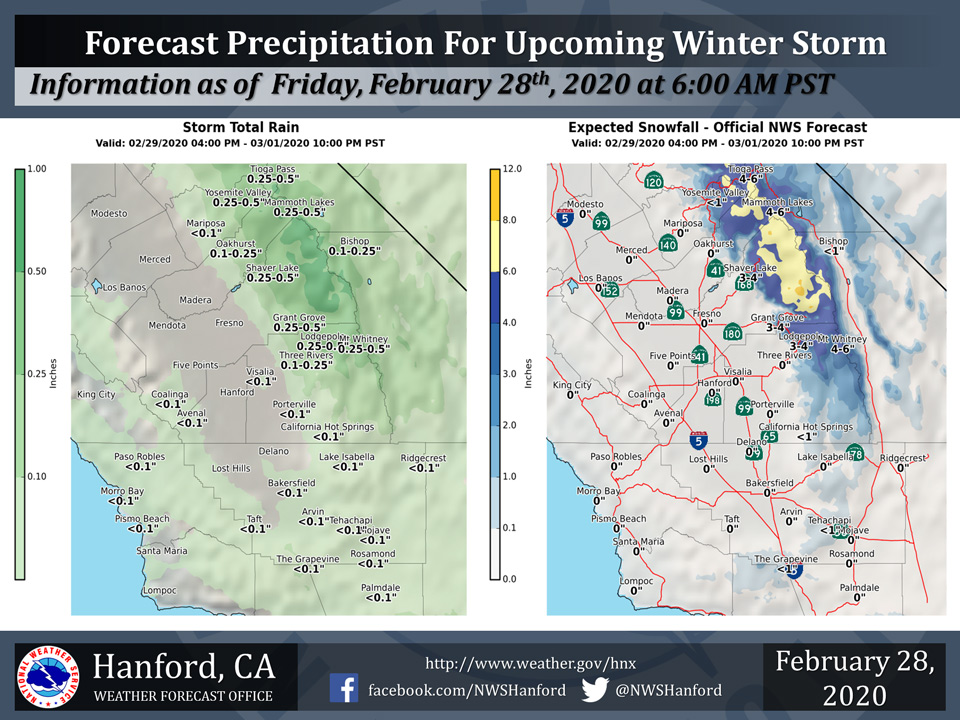
Mariposa projected rainfall totals for weekend weather system less than 0.10"
Oakhurst projected rainfall totals for weekend weather system 0.10" to 0.25"
Yosemite Valley projected rainfall totals for weekend weather system 0.25" to 0.50"
February 28, 2020 - The National Weather Service Hanford Office reports a storm system will bring mainly light rain and mountain snows to parts of the Central California Interior from late Saturday afternoon through Sunday night.
Snow levels will drop as low as 3000 feet Sunday.
Above are the latest projected rain and snowfall amounts.
  Area Forecast Discussion
  National Weather Service Hanford CA
  410 AM PST Fri Feb 28 2020


  .SYNOPSIS...Near-record high temperatures are possible across the
  much of the San Joaquin Valley today. A storm system will bring
  much cooler weather and a chance of showers to much of the
  district on Sunday, with the best chances of measurable
  precipitation remaining in the Sierra and Kern County mountains.
  Ridge builds back into the region by next week, with dry weather
  returning to the area.

  &&

  .DISCUSSION...IR satellite imagery showing extensive cloud cover
  across the district which has kept current temperatures in the
  50s. Low temperatures will end up near 50 in most locations, which
  is more common for late April! Despite the overcast skies,the
  central California interior will experience one last day of near-
  record temperatures. The daily record for Fresno is 79 degrees,
  with an expected high of 81 degrees. Bakersfield`s record high
  temperature for the date is 81 degrees, with an expected high of
  82 degrees. The upper level ridge responsible for the warm
  temperatures continues to shift east, giving way to a zonal flow
  by this evening.

  Zonal flow will remain across the area for a majority of Saturday
  before turning to more of a southwesterly flow ahead of the
  approaching system. Cooler, onshore flow will lower temperatures
  by as much as 10 degrees across the valley, but will still remain
  above normal by 5 to 10 degrees for this time of year. A few
  orographic showers will be possible in the higher elevations of
  the Sierra by Saturday evening.

  Main cold core of the upper level low will drop south through the
  region on Sunday. Models are beginning to show subtle differences
  in the exact positioning of the upper level low. The
  GFS/ECMWF/GDPS model solutions show the cold core further west
  near the Bay Area, and subsequently drawing more moisture into
  the system. However, the NAM and higher resolution NAM12 has the
  upper level low centered near Mono Lake, which would translate
  into much less precipitation. Since the NAM12 is the sole outlier,
  we have opted to go with a more western track of the cold core
  low. This model solution is also more in line with the current
  WPC/NBM QPF guidance. As the main cold core low move over the
  region, instability will increase across the area and isolated
  thunderstorms are possible on late Sunday morning and afternoon.
  Small hail and dangerous lightning are the primary threats.
  Additionally, temperatures will continue to drop, with high
  temperatures remaining in the 50s.

  This system is not expected to produce significant rainfall in
  the valley nor Kern County desert, with amounts generally at 1/10
  of an inch or less. Higher QPF amounts is expected in the Sierra,
  with general amounts between 1/4 to 2/3 of an inch. Lighter
  QPF amounts are expected into Kern County mountains, where
  between 1/10 and 1/4 of an inch is possible. Snow is expected in
  the Sierra, especially north of Tulare County into Yosemite
  National Park. Since this is a colder system, snow levels across
  the district will drop to as low as 3000 feet by Sunday morning,
  where a dusting is possible along the Grapevine and Tehachapi
  Pass. Snowfall totals will increase going northward, where general
  amounts between 3 to 6 inches, with locally up to 8 inches.

  On Monday, the attention will turn from precipitation to the
  chance of strong winds in the Central Sierra mountains and
  foothills. Models are showing strong northeasterly winds aloft
  late Sunday into Monday. Again, the uncertainty with the exact
  position and strength remains low at this time.

  From Tuesday into the end of the forecast period next Friday,
  Ridge of high pressure returns to the area. Temperatures will
  once again increase to above normal values along with dry weather
  returning to the area.
Source: NWS

