


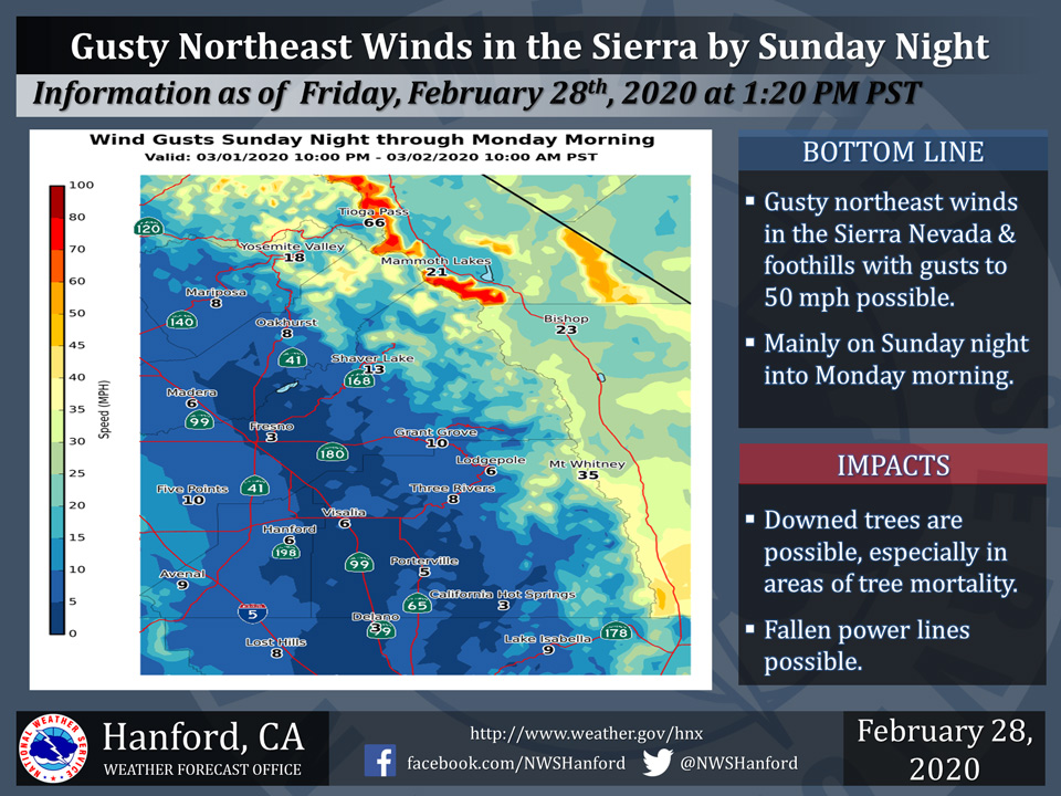
Projected wind gusts up to 8 mph for Mariposa and Oakhurst
Projected wind gusts up to 18 mph for Yosemite Valley
February 28, 2020 - The National Weather Service Hanford Office reports gusty northeast winds are expected Sunday night into Monday morning in the Sierra Nevada and adjacent foothills from Yosemite to Kings Canyon National Parks; expect local gusts around 50 miles per hour, especially over ridge tops and through northeast-southwest oriented canyons.
Stronger gusts are expected over the Sierra Nevada crest.
Downed trees and branches, along with power outages, are likely, including in areas of tree mortality.
  Area Forecast Discussion
  National Weather Service Hanford CA
  258 PM PST Fri Feb 28 2020

  .SYNOPSIS...Dry weather and above normal afternoon temperatures
  can be expected over the district through Saturday. A storm
  system will bring showers and a change to much cooler weather
  Saturday night and Sunday. Brisk northeast winds are likely in
  the foothills and higher elevations of the Sierra north of Kings
  Canyon Sunday night into Monday. Otherwise, dry weather will
  prevail next week with a day to day warming trend.

  &&

  .DISCUSSION...Residents of the central California interior have
  been getting spoiled by unseasonably warm afternoons lately. This
  afternoon is no exception. In spite of a good deal of high
  cloudiness and limited sunshine, temperatures are trending higher
  this afternoon in most locations compared to 24 hours ago. The
  high clouds are forerunners of a storm system that will surely
  bring an abrupt end to our spell of Springlike warmth by Sunday.

  That storm is still situated over the Gulf of Alaska and it will
  bring a variety of impacts to our region later in the weekend.
  More on that later. In the shorter term, a fairly weak upper
  level low that`s poised offshore the central California coast
  will drift inland tonight. This feature is the primary source of
  high clouds, and they`ll continue to be carried into central
  California during the next 24 hours by southwesterly winds aloft.
  Otherwise, our weather will remain dry through Saturday. High
  temperatures will trend a bit lower Saturday but still remain
  several degrees above normal.

  Our focus then turns to that cold storm over the Gulf of Alaska.
  As the storm approaches from the northwest, it will bring an
  increase in clouds and onshore flow by Saturday evening.
  Northwest winds will increase a bit in the San Joaquin Valley
  by then while westerly winds become gusty through and below
  the Kern county mountain passes. The upper level jet to the south
  of this system will also generate orographic precipitation over
  the Sierra Saturday night.

  On Sunday, the cold core low will move right over central
  California and generate instability showers over the CWA. Although
  showers will be most numerous over the mountains, they cannot be
  ruled out in the lower elevations. The upper level jet will be
  south of our CWA by then, so this will put our CWA in a favorable
  environment for thunderstorm development Sunday afternoon into
  early Sunday evening. Although thunderstorms will be isolated, any
  of them can drop small hail. Precipitation totals from this storm
  will be rather nominal; generally less than a tenth of an inch
  in the San Joaquin Valley, foothills and the Kern county desert
  with as much as a half inch in the Sierra by Sunday evening. It
  will be cold enough for at least a dusting of snow down to the
  3,000 foot level later this weekend. This could disrupt travel
  for motorists driving through the mountain passes of Kern county
  Sunday into Sunday evening. The storm could also produce local
  snow accumulations of up to 6 inches in the Sierra above 5,000
  feet by Sunday evening.

  The cold air accompanying our late weekend storm will be a rude
  awakening for many, particularly for hikers and campers in the
  high Sierra. Wind chill temperatures in the high Sierra will be
  below zero later this weekend. Even in the lower elevations,
  temperatures will pack a cold sting compared to recent days. In
  the San Joaquin Valley, lower foothills and the Kern County
  desert, afternoon temperatures Sunday will be no higher than the
  50s in most locations. If so, it will be the coolest day since
  February 5th. Temperatures Sunday over the mountains may rise
  very little from their early morning readings, as well and it
  will be a reminder that Winter hasn`t given up yet.

  The models forecast this storm to continue its southward trek
  Sunday night and position it near the coast of northern Baja
  by Monday morning. During this time, a strong northeast to
  southwest oriented 300 mb jet (120 knots) will settle over our
  CWA. Synoptically, this is an ideal set up for a Mono wind event
  in the Sierra. Locally strong northeast winds are likely in the
  Sierra north of Kings Canyon Sunday night through midday Monday.
  Local wind gusts of up to 50 mph are possible in this region
  during this time along with downed trees and possible power
  outages.

  A dry northerly flow aloft will reside over California from
  Monday afternoon into Tuesday. Frosty daybreak temperatures can
  be expected in the San Joaquin Valley early next week in this
  pattern with minimum temperatures near the freezing mark in
  the coldest locations early Monday morning and Tuesday morning.
  This will be a very brief cold snap, however, since a nice day
  to day warm up will follow in the Tuesday through Thursday
  time period as a short wave ridge of high pressure moves in over
  central California. High temperatures should bounce back into
  the 70s in the San Joaquin Valley, lower foothills and the Kern
  county desert by days 6 and 7. Otherwise, next week looks like
  it will be another dry one. Some encouraging news is on the
  horizon, however. The longer range models are now hinting of
  a pattern change to wet weather during the second week of March.
  That would be a very welcome change to an otherwise pitifully
  dry 2020, so far.
Source: NWS

