


Projected high temp for Mariposa on Saturday: 66 degrees; Sunday 49 degrees
Projected high temp for Oakhurst on Saturday: 66 degrees; Sunday 47 degrees
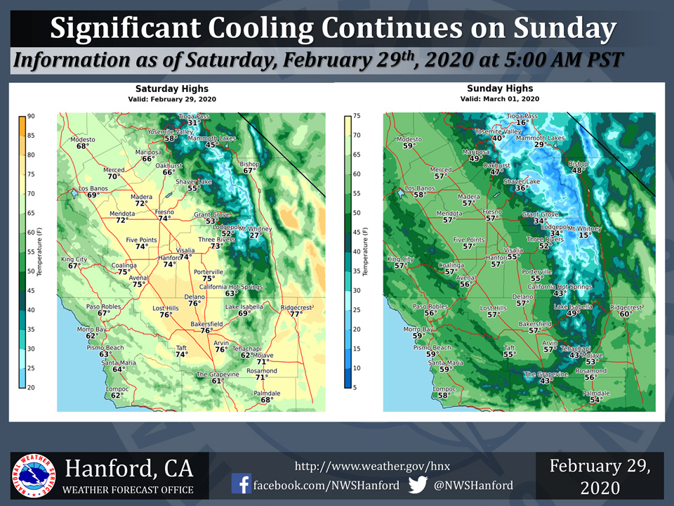
Projected high temp for Yosemite Valley on Saturday: 58 degrees; Sunday 40 degrees
February 29, 2020 - The National Weather Service Hanford Office reports afternoon high temperatures on Sunday will be as much as 15 degrees cooler compared to today’s expected high temperatures.
Increasing winds along with rain showers and higher elevation snowfall will accompany the cool down.
  Area Forecast Discussion
  National Weather Service Hanford CA
  445 AM PST Sat Feb 29 2020


  .SYNOPSIS...A storm system will bring showers and a change to
  much cooler weather by later tonight and Sunday. Periods of
  gusty winds are expected late tonight into Monday. Otherwise, dry
  weather will prevail next week with a day to day warming trend.

  &&

  .DISCUSSION...
  Numerous high clouds continue to stream inland overhead while a
  weak ripple in the upper level flow pushes ashore near southern
  California. Meanwhile, our temperatures are running similar to 24
  hrs ago and lows this morning should again be several degrees
  above normal. The high cloudiness and weak disturbance will help
  keep our highs several degrees lower than yesterday`s readings but
  we will still be running above normal for the end of February.

  A storm system dropping out of the northeast Pacific will have a
  more significant impact on our weather as it pushes through our
  region by later tonight into Sunday. Increasing onshore surface
  pressure gradients will bring gusty westerly winds through and
  below mountain passes. High resolution models are suggesting there
  could be some wind gusts over 60 mph in portions of the Kern
  County mountains and desert areas late tonight through late
  afternoon Sunday. We have issued a High Wind Watch for these
  possibly damaging winds.

  This system will not steer large amounts of moisture into our
  region but will provide some mountain snow with snow levels
  lowering as low as around 3000 ft. Significant accumulations will
  however be confined to higher elevations, with as much as 4-7
  inches expected around 6000 feet and higher over the Sierra Nevada
  from Kings Canyon northward. A Winter Weather Advisory is in
  effect there from late this evening through Sunday Afternoon. As
  the system pushes south and snow levels lower, we could see a
  dusting of snow down to pass levels in the Kern County mountains
  later Sunday into early Monday morning. Significant snow
  accumulations are not expected in Kern County at this time, but
  rain slickened roads even without snow can make travel more
  difficult through the mountains.

  The track of the upper level low is progged to generally stay along
  the California coast or just offshore as it drops southward. This
  will keep chances for thunderstorms on Sunday mainly to our west
  and south but there could be enough instability over our area to
  spark a thunderstorm during the afternoon and evening Sunday. The
  storm system will otherwise drop our temperatures significantly,
  and highs Sunday will be lowered to as much as 6-12 degrees below
  climo.

  As the upper low swings inland near northern Baja Sunday night
  into Monday morning, easterly flow over the top of the low will
  lead to favorable conditions for strong Mono-like northeasterly
  winds across the Sierra zones north of Tulare County.
  After Monday, as the system swings eastward across northern
  Mexico and high pressure builds along the US west coast, we will
  have dry and warming conditions into the end of next week.
Source: NWS

