


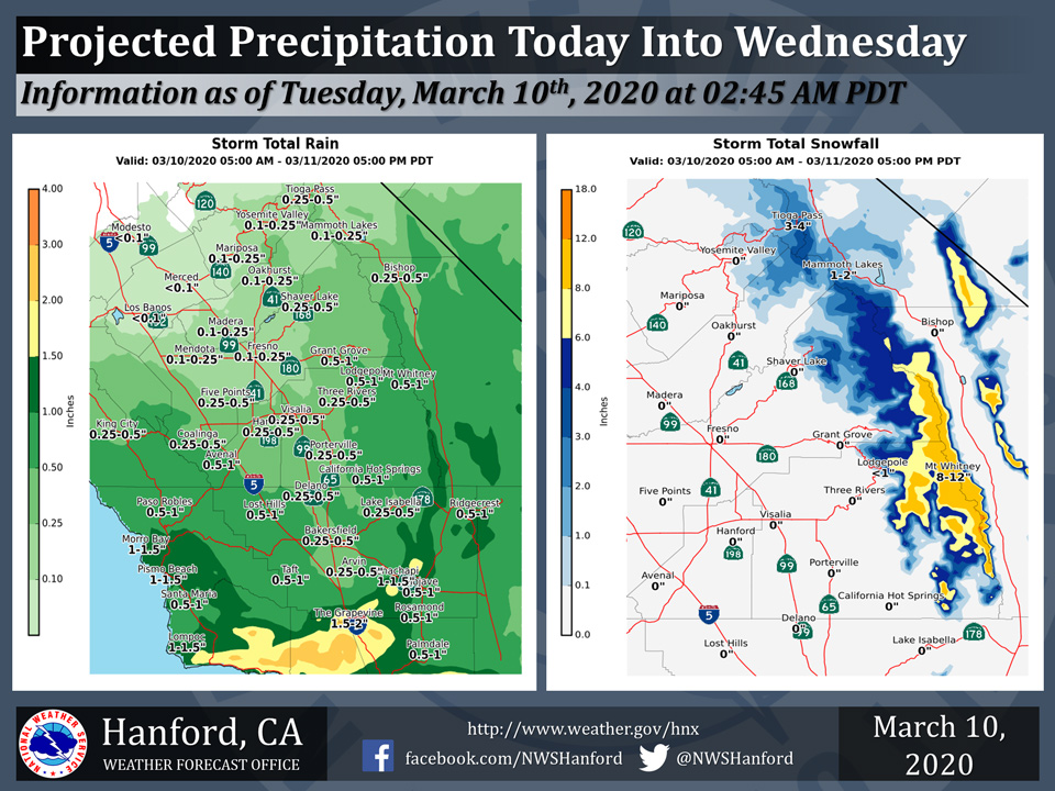
Projected rainfall for Mariposa 0.10" to 0.25"
Projected rainfall for Oakhurst 0.10" to 0.25"
Projected rainfall for Yosemite Valley 0.10" to 0.25"
March 10, 2020 - The National Weather Service Hanford Office reports a storm system will impact Central California today into Wednesday.
Intense rainfall rates are possible in the Kern County mountains this afternoon through this evening, resulting in the threat of mudslides and rockslides.
A winter weather advisory is in effect for heavy snow in the Tulare County portion of the Southern Sierra Nevada above 7,000 feet, with the heaviest snow possible this afternoon and evening.
  Area Forecast Discussion
  National Weather Service Hanford CA
  338 AM PDT Tue Mar 10 2020


  .SYNOPSIS...
  An Eastern Pacific storm system will approach the coast of
  California through Wednesday. Significant rainfall is likely in
  the Kern County mountains and desert Tuesday afternoon and Tuesday
  night. This storm system should stall just offshore of California
  Wednesday, before shifting southward Wednesday night and
  Thursday.

  &&

  .DISCUSSION...
  Lots of cloud cover across central CA due to the next weather
  system off the central CA coast. Weather radars indicated rain
  bands have already pushed over the Los Angeles basin. The weather
  system is a closed mid level trough which may move slowly
  affecting the central CA weather for the next two days. Satellite
  images show the tropical atmospheric river remains well south of
  the trough towards Baja. However precipitable water estimates off
  the S CA coast are relative high around 150 percent of normal.
  Models prog for the trough moving east towards point conception
  through Wednesday. The Southern half of the district will be the
  favorable quadrant for dynamic lift. This will bring a threat of
  rain especially over the Kern county mountains and desert. In
  addition low level flow from E-SE will enhance the orographic lift
  over Tehachapi mountains through this afternoon resulting in an
  increase threat for heavy rain. Wind flow weakens and turns more
  south in the evening decreasing the threat of heavy rain
  overnight. Thunder will be possible this afternoon with strong
  dynamics and models indicating some instability towards the south
  valley. However CAPE values are fairly low less the 100J/Kg.
  Instability values are greater and more widespread on Wednesday
  due to cooler air aloft, thus thunder will possible again
  Wednesday afternoon.

  Rain totals will vary considerably from north to south, with less
  than one tenth of an inch expected in Merced County to as much as
  around one and one half of an inch to two inches in the Kern
  County mountains. A Flash Flood Watch is in effect for the Kern
  County mountains and desert Tuesday afternoon and Tuesday night
  due to the potential for rockslides and mudslides. A foot of snow
  is likely along the Sierra Nevada crest of Tulare County, mainly
  Tuesday afternoon through Wednesday morning. A Winter Weather
  Advisory is in effect for the Tulare County portion of the
  Southern Sierra Nevada above 7000 feet Tuesday through Wednesday.
  The storm system approaches point conception Wednesday afternoon,
  before shifting southward Wednesday night and Thursday.
  Precipitation chances will decrease Wednesday night and Thursday
  as the storm system moves farther away from Central California.
  The storm system moves onshore over the Baja Peninsula Thursday
  night. A ridge of high pressure over the E Pac will build E over
  CA Friday and into the upcoming weekend.

  A colder weather system may impact Central California late this
  weekend or early next week. Forecast confidence is low regarding
  the timing and strength of this weather maker.
Source: NWS

