


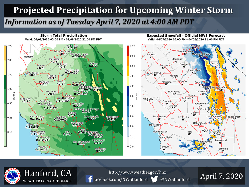
Projected rainfall totals for Mariposa: Less than 0.10"
Projected rainfall totals for Oakhurst: Less than 0.10"
Projected rainfall totals for Yosemite Valley: Less than 0.10"
April 7, 2020 - The National Weather Service Hanford Office reports a storm system will impact the Southern Sierra Nevada from Fresno County southward into the Kern County mountains starting this afternoon through Wednesday night.
6 to 12 inches of snow is expected above 5,000 feet with locally higher amounts of up to 18 inches.
Rainfall totals of up to 1-1.5 inches with higher amounts are possible in the mountains.
Between 0.5-1 inches is expected for most of Kern County, while lower amounts are expected in other parts of the valley.
  Area Forecast Discussion
  National Weather Service Hanford CA
  224 AM PDT Tue Apr 7 2020

  .SYNOPSIS...
  Low pressure will move down the California coast today and into
  Southern California Wednesday and Thursday. Unsettled and cool
  weather will continue with lower elevation rain and mountain snow
  for especially southern parts of the region.

  &&

  .DISCUSSION...Strong cyclonic flow and difluence aloft continue
  this morning over the Central California Interior as low pressure
  spins about 200 miles west of the Central Coast. Water vapor
  imagery shows several embedded vorticity centers (or areas of
  spine within the overall spin) rotating around the low center. As
  the parent low center slowly moves to the south the flow into the
  forecast area is beginning to shift from the southwest to the
  south.

  So how does the pattern evolve? For today with forecast models
  bringing the center of the big offshore low to a location about
  200 miles west of Point Conception the flow into the region will
  shift to the south by later this afternoon and this will push
  moisture northward into Kern County. During the evening and into
  tonight the low is projected to move to the east with the center
  position just south of the Channel Islands by Wednesday morning
  and the resulting flow becoming southeast. Taking things into
  Wednesday afternoon, models move the center of the low east into
  San Bernardino County and this will allow the moist flow to turn
  to the east over Kern County and the Southern Sierra. This south
  to southeast to east flow pattern is ideal for precipitation in
  the Southern Sierra and Kern County areas.

  Model projected precipitation suggests a good long lasting
  soaking rain for the lower elevations and significant snow above
  5500 feet in the mountains. A Winter Storm Warning has been issued
  for the Sierra from Sequoia Park southward across the Piutes,
  Tehachapi and San Emigdio ranges from late this afternoon through
  Wednesday evening where heavy snow is likely. Snow levels will
  likely stay above pass level on the Grapevine and Tehachapi
  Passes, however Walker Pass could receive up to several inches of
  wet snow by Wednesday night as well as Pine Mountain Club and
  areas just above Frazier Park. Upper Bear Valley Springs should
  get some snow too.

  Since this low pressure system is a "cutoff" low (meaning
  separated from the jet stream and steering currents) it will only
  slowly move east on Thursday to the Lake Mead vicinity thus some
  northeast flow wrap around showers will persist over the Sierra
  and Kern County mountain and desert areas. By Thursday night and
  Friday the low is progged to sag into southwest Arizona and the
  Central California Interior will be precipitation free in the dry
  northerly flow behind the low. All in all a good precipitation
  event to continue, this time for the south.
Source: NWS

