


California and National Drought Summary for June 9, 2020
Summary
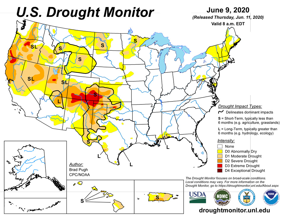
June 11, 2020 - A strong upper-level ridge developed over the Southwest at the beginning of June, and expanded east to the southern Great Plains. 7-day temperatures (June 2 to 8) averaged more than 10 degrees F above normal across much of the southern to central Great Plains until a strong cold front arrived on June 9. From June 6 to 8, a vigorous upper-level trough progressed east and resulted in varying amounts of rainfall and much cooler temperatures from the Pacific Northwest to the northern Rockies and northern Great Plains. Around the periphery of the upper-level ridge, mesoscale convective systems with severe thunderstorms and locally heavy rain (more than 2 inches) occurred from the Upper and Middle Mississippi Valley southeast to the mid-Atlantic. After spending multiple days stationary over southern Mexico, Tropical Storm Cristobal tracked north across the Gulf of Mexico and made landfall in southeast Louisiana on June 7. The heaviest rainfall occurred to the east of its landfall. 7-day precipitation amounts (ending 12Z June 9) exceeded 5 inches, with locally higher amounts, from the Mississippi Gulf Coast east to the Florida Panhandle. A weak surface low remained located across the Gulf of Alaska at the beginning of June. The most widespread rainfall (more than 1 inch) occurred across southeast coastal Alaska, while scattered convection raised wildfire concerns over the interior of Alaska. Rainfall was suppressed ¬across Hawaii this past week, while heavy rainfall occurred well west of Puerto Rico during the first week of June.
Northeast
Year-to-date precipitation deficits continue to increase across New England, with 3 to 6 inch deficits from coastal Maine south to Long Island, New York. These increasing deficits along with low 28-day streamflows prompted an expansion of abnormal dryness (D0). Farther to the south across the mid-Atlantic and central Appalachians, abnormal dryness was introduced to parts of the southern Delmarva Peninsula, Maryland, Pennsylvania, and West Virginia where 30-day precipitation deficits exceed 2 inches and 28-day streamflows along with soil moisture have fallen below the 30th percentile. NLDAS soil moisture at 20 cm also supports the pockets of D0 across the mid-Atlantic.
Southeast
Heavy to excessive rainfall (3 to 10 inches, or more), associated with Tropical Storm Cristobal and prior to its landfall, resulted in 1 to 2-category improvements across Florida and Alabama. 2-category improvements were justified across much of the Florida Panhandle with the absence of long-term precipitation deficits. As of June 9, Pensacola, Florida has received 3.42 inches of rainfall so far this month. Moderate long-term drought is designated for the greater Mobile Bay area east to Pensacola due to continued precipitation deficits dating back to 90 and 180 days. The drought designated along the Gulf Coast was changed from SL to L.
South
Drought continues to rapidly develop and intensify across the southern Great Plains. During a relatively wet time of year, precipitation has averaged less than 50 percent across much of western Oklahoma and the Texas Panhandle. This lack of rainfall coupled with periods of much above normal temperatures and strong winds have dried out topsoils quickly. According to the USDA’s National Agricultural Statistics Service, topsoil moisture being rated as short or very short across Oklahoma increased from 23 to 53 percent during the past week. Conversely, 1 to 2-category improvements were made along the Gulf Coast. Total rainfall amounts, associated with Tropical Storm Cristobal, included 8 inches at Pascagoula, Mississippi. Moderate long-term drought remains designated for the Mississippi Gulf Coast due to precipitation deficits dating back to 90 and 180 days.
Midwest
The Corn Belt remains drought-free due to long-term precipitation surpluses along with favorable soil moisture at depth. As of 12Z on June 9, short-term deficits and drying topsoils supported the addition of a small area of D0 in the northwest corner of Iowa. This region will be reassessed next week since heavy rain fell after the valid time for this week’s USDM. Southeast Illinois and western Kentucky are beginning to dry out. Since 28-day streamflows and soil moisture remain above the 40th percentile, abnormal dryness (D0) was not added this week to southeast Illinois or western Kentucky. Heavy rain (1 to 5 inches) resulted in a 1-category improvement across northwest Minnesota, while moderate drought (D1) was expanded slightly south and east.
High Plains
Extreme drought (D3) was expanded across southeast Colorado based in part on soil moisture in the lowest 5th percentile. Above normal temperatures coupled with periods of strong winds continue to result in rapidly worsening conditions and reports of widespread selling of cattle. Trinidad, Colorado recorded only 1.66" of precip year-to-date which is the driest January 1-June 9 on record. Data here dates back to 1948.The intensifying and developing drought conditions across Oklahoma also extended into the southern two-thirds of Kansas. This region missed out the widespread rainfall farther to the north across Nebraska and much above normal temperatures prevailed during the first week of June. Following the previous week’s expansion of abnormal dryness to cover a majority of Wyoming, moderate short-term drought (D1) was added to parts of Wyoming where the largest 60 to 90-day precipitation deficits along with SPI values support it. Widespread 7-day amounts of 1 or more inches of rainfall precluded additional expansion of abnormal dryness (D0) across much of the northern Great Plains, while there was a slight reduction of D0 across western Nebraska based on 7-day rainfall amounts.
West
Drought is rapidly developing or intensifying across northern and eastern New Mexico. Abnormal dryness was introduced to southeast Arizona based on SPI values. In addition, May 2020 was the 5th warmest May on record which is likely exacerbating the dyrness as a number of wildfires have developed. Abnormal dryness (D0) and moderate drought (D1) was expanded across southwest Utah, while the addition of extreme drought (D3) to Utah was supported by SPI values at various time scales. Farther to the north across Montana, widespread precipitation precluded a large expansion of abnormal dryness except for areas bordering Canada.
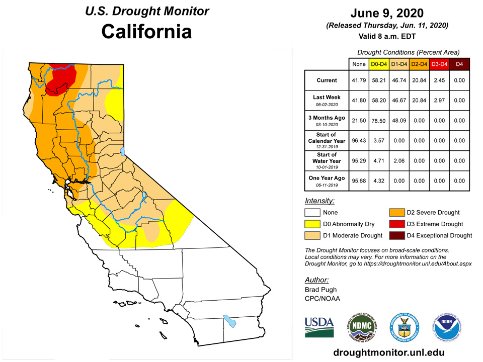
Unseasonably heavy precipitation, including high-elevation snow, prompted a slight decrease in the coverage of severe drought (D2) across parts of northeastern Utah. This decrease occurred where more than 1 inch (liquid equivalent) was observed. Likewise, 7-day precipitation (more than 1 inch) along with a wet late spring resulted in a slight decrease in extreme drought (D3) across northern California and severe drought (D2) in the southwest corner of Washington. Above normal precipitation during May into the beginning of June along with an increase in 28-day streamflows prompted slight improvements, while conditions worsened east of the Cascades. An increase in soil moisture and easing of long-term precipitation deficits resulted in a small 1-category improvement to the drought status across northeast Washington.
Alaska, Hawaii, and Puerto Rico
Severe drought (D2) was expanded across Molokai, based on NDVI and VHI. The NDVI data also supports D2 along the lower leeward slopes of Haleakala near Kihei on Maui. D2 was also added to the lower leeward slopes of the South Kohala District on the Big Island, based on NDVI and VHI data.. 60-day precipitation deficits continue to increase and 28-day streamflows (below the 20th percentile) supported an expansion of D1 across southeastern Puerto Rico. Areas that were designated with moderate drought (D1) the previous week were degraded to severe drought (D2). Alaska remains drought-free.
Pacific Islands
Several weather features contributed to precipitation across the U.S.-Affiliated Pacific Islands (USAPI) during this USDM week (6/03/20-6/09/20). An Inter-Tropical Convergence Zone (ITCZ), associated with converging trade winds due to differential wind speeds, spread across Micronesia from the Republic of the Marshall Islands (RMI) in the east, across the Federated States of Micronesia (FSM), to the Republic of Palau in the west. Surface troughs and tropical disturbances, as well as weak circulations, migrated through the ITCZ. A dry trade-wind flow dominated northern sections of Micronesia, but surface troughs and an upper-level low migrated westward across western sections. Divergence aloft associated with the low enhanced precipitation generated by surface features across Palau and Yap State and even parts of the Marianas. Near the end of the week, a surface circulation (Invest 98W) enhanced rainfall over Palau and western Yap State. South of the equator, a surface ridge of high pressure kept the weather dry over American Samoa for much of the week. Instability associated with a nearby moist air mass spread showers into the region at mid-week.
Satellite-based estimates of 7-day precipitation (QPE) showed a wet pattern associated with the ITCZ extending across the Pacific between roughly the equator and 10 degrees north latitude, and another wet band extending southeastward from Indonesia to west of the Samoan Islands associated with the South Pacific Convergence Zone (SPCZ). A large area of 2+ inches of rain was evident across Yap and Chuuk states and Palau, with embedded drier areas, and some of the rain bands reached the southern Marianas. Smaller areas of 2+ inches of rain spread across parts of eastern FSM and southern RMI. Little to no rain was indicated across northern RMI. The QPE showed rain bands extending across western and northern portions of the Samoan region, with little rain detected by satellite across American Samoa.
At Palau IAP, 5.29 inches of rain fell this week, and Koror recorded 6.32 inches of rain. Thus, Palau remained free of drought or abnormal dryness this week.
This week in American Samoa, conditions became drier, though it has not yet become abnormally dry. Pago Pago recorded 0.69 inches of rain, Suifaga Ridge recorded 0.70 inches, and Toa Ridge recorded 0.63 inches.
On Kwajalein, short- and long-term moderate drought continued, as only 0.65 inches of rain fell there this week, and March, April, and May all missed the monthly minima. On Ailinglapalap, short-term abnormal dryness continued, though with 2.80 inches of rain (1 day missing), weekly minimum rainfall has been reached for the second consecutive week. On Jaluit, 1.66 inches of rain fell this week, making two consecutive weeks below their weekly minimum. However, short-term abnormal dryness has not developed, given 11.23, 12.19, and 13.80 inches of rain in March, April, and May, respectively. No data was available at Utirik, so no depiction was made there. Short- and long-term extreme drought continued on Wotje, where 0.60 inches of rain fell this week, with one day missing. On Majuro, 1.25 inches of rain fell this week; however, short-term dryness has not developed, as most other recent weeks have met the weekly minimum rainfall. On Mili, 0.93 inches of rain fell this week, with one day missing. However, most other recent weeks met their weekly minimum rainfall, and drought-free conditions continued.
On Saipan this week, conditions degraded to short- and long-term exceptional drought. Saipan recorded 0.07 inches of rain this week, which continued a long string of weeks that missed the one-inch weekly minimum. Additionally, poor vegetation health supported the degradation to exceptional drought. Short-term extreme drought continued on Rota, though 1.03 inches of rain fell this week, marking the second consecutive week when the weekly minimum was reached. Short-term moderate drought continued on Guam, but 1.23 inches rain fell there this week, so very short-term conditions are improving there.
Short-term severe drought continued on Yap this week; however, 6.70 inches of rain fell this week, so short-term conditions are beginning to improve there. Short-term moderate drought continued this week on Ulithi, where 1.01 inches of rain fell. Short-term moderate drought also continued on Woleai this week, though 4.24 inches of rain fell, improving conditions in the very short term. The last couple weeks on Fananu both recorded less than one inch of rain, indicating at least some very short-term dryness, though with a few missing days of data. However, most data beyond the last couple weeks are unavailable, so no drought depiction was made this week. Short-term abnormal dryness continued on Chuuk, though with 3.38 inches of rain this week, conditions continue to improve. On Lukunor, 3.55 inches of rain fell this week, and drought-free conditions continued. On Nukuoro, 4.95 inches of rain fell this week, continuing a stretch of most recent weeks hitting their weekly minimum, and drought-free conditions continued. Short-term abnormal dryness continued on Kapingamarangi, where 1.10 inches of rain fell, marking the fourth consecutive week with below weekly minimum rainfall. On Pohnpei, 1.01 inches of rain fell this week, marking the second consecutive week below weekly minimum rainfall. However, April and May saw 23.04 and 24.91 inches of rain, so no abnormal dryness is taking place. Pingelap recorded 2.10 inches of rain, and drought-free conditions continued there. On Kosrae, 3.55 inches of rain fell, continuing their drought-free conditions.
Virgin Islands
Severe short-term drought continued this week on St. Thomas and St. John. Short-term SPI on both islands still show significant precipitation deficits at 1 and 3 months, and groundwater remained low in both locations. On St. Croix, short- and long-term severe drought continued, as SPI out to 12 months converged on severe drought, and groundwater remained low.
Looking Ahead
On June 11, a cold front is forecast to cross the eastern U.S. Surface high pressure, behind this front, is likely to result in mostly dry weather from the Appalachians west to the Rockies. Along with the dry weather, a return of above normal temperatures is likely across the central and southern Great Plains. From June 11-15, the heaviest precipitation (locally more than 1 inch) is forecast across the eastern Carolinas and Florida Peninsula. Following the heavy to excessive rainfall during early June, an extended period of dry weather is likely along the Gulf Coast. Seasonal dryness is forecast across the Southwest and California, while occasional light precipitation occurs across the Pacific Northwest.
The CPC 6-10 day outlook (June 16-20) indicates increased chances of above normal temperatures extending from the Great Plains northeast to the Great Lakes and New England with below normal temperature most likely across the northern Rockies. A large area with increased chances of below normal precipitation covers most of the Great Plains, Mississippi Valley, Corn Belt, and Gulf Coast States. A slight tilt toward above normal precipitation is limited to the mid-Atlantic, south Florida, and parts of the Pacific Northwest and northern Rockies. Above normal temperatures are favored throughout Alaska along with slightly elevated probabilities of above normal precipitation.
Author(s):
Brad Pugh, NOAA/CPC
Curtis Riganti, National Drought Mitigation Center
Dryness Categories
D0 Abnormally Dry—used for areas showing dryness but not yet in drought, or for areas recovering from drought.
Drought Intensity Categories
D1 Moderate Drought
D2 Severe Drought
D3 Extreme Drought
D4 Exceptional Drought
Drought or Dryness Types
S Short-Term, typically less than 6 months (e.g. agricultural, grasslands)
L Long-Term, typically greater than 6 months (e.g. hydrologic, ecologic)
Source: National Drought Mitigation Center

