


Includes Mariposa and Oakhurst
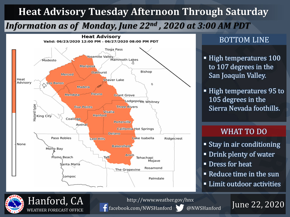
June 22, 2020 - The National Weather Service Hanford Office has issued a Heat Advisory for the San Joaquin Valley and Sierra Foothills from Tuesday afternoon through Saturday afternoon.
A prolonged period of hot afternoon temperatures is expected this week into the weekend.
This will be the longest stretch of triple digit heat so far this year which could put additional stress on folks that are not acclimated to hot weather and are susceptible to heat stroke and heat exhaustion.
To lower your risk of heat related illness, it’s important to stay hydrated, and remain in an air conditioned home or building.
Avoid spending much time outdoors during the hottest time of the day, generally between noon and 6 pm PDT.
If you must be outdoors, wear light colored, loose fitting clothing, a protective hat and sunscreen.
Never leave pets or children in your car on a hot afternoon.
  Area Forecast Discussion
  National Weather Service Hanford CA
  325 AM PDT Mon Jun 22 2020

  .SYNOPSIS...
  A prolonged period of dangerously hot temperatures are expected
  in the San Joaquin Valley, Sierra Nevada foothills, and Indian
  Wells Valley Tuesday afternoon through Saturday afternoon.

  &&

  .DISCUSSION...
  High pressure at the upper levels will build north from Baja and
  increase temperatures across the CENCAL interior through the week.
  We have upgraded the Excessive Heat Watch to a Heat Advisory
  starting tomorrow and continuing through Saturday for the San
  Joaquin Valley. The GFS is in agreement with the ECM through
  Thursday, then they begin to split in their solution afterwards.
  The GFS is digging a trough into CENCAL by Thursday and cooling us
  off some...still above normal. The ECM is keeping ridging in over
  us through Saturday before a stronger trough will move into the
  area by Saturday night and a significant cool down on Sunday. The
  National Blended Model is keep us hot through Saturday and is
  leaning more towards the ECM at this time. Triple digits started
  in the SJV last Friday and are expected to continue through this
  upcoming Saturday...which is 8 days. When we have prolonged triple
  digits for this period of time, it can really begin to wear people
  down. Please take time to stay cool and hydrated during this
  prolonged period of dangerous heat.

  There will be some isolated thunderstorms along the crest on
  Tuesday and Wednesday afternoon as a weak trough will clip the
  Sierra and provide some lift for a possible afternoon thunderstorm
  or two.
Source: NWS

