


Very Warm to Hot Temperatures Today for Mariposa, Oakhurst and Yosemite Valley
Mariposa: Sunny and hot today with a high temp of around 101 degrees today with a low temp of around 63 degrees. Possible wind gusts up to 15 mph tonight.
Yosemite Valley: Increasing clouds today with a high temp of around 98 degrees with a low temp of around 59 degrees.
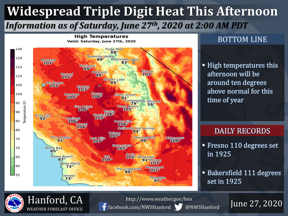
June 27, 2020 - The National Weather Service Hanford Office reports widespread triple digit heat will impact the San Joaquin Valley this afternoon.A Heat Advisory is in effect for the San Joaquin Valley and Sierra Nevada foothills until 8:00 P.M. this evening.
A cooling trend is expected Sunday and Monday.
  Area Forecast Discussion
  National Weather Service Hanford CA
  242 AM PDT Sat Jun 27 2020

  .SYNOPSIS...Hot and dry weather will prevail over the central
  California interior today. Sunday and Monday will trend much
  cooler with gusty winds across the region on Sunday. The rest of
  next week will be dry with temperatures recovering to near normal
  by midweek.

  &&

  .DISCUSSION...IR imagery indicating mainly clear skies across our
  area overnight as high pressure strengthens over our region for
  one day. Rises in heights and thicknesses will result in maximum
  temperatures between 104 and 107 DEG F across much of the San
  Joaquin Valley and Kern County Deserts today as well as triple
  digit heat for the Sierra foothills. A Heat Advisory remains in
  effect for the San Joaquin Valley and Sierra foothills until 800
  pm this evening.

  A big change is expected on Sunday and Monday as an upper low
  pressure system pushes through the PAC NW and forces the upper
  ridge that has been responsible for the widespread triple digit
  heat over the San Joaquin Valley and Kern County Deserts
  retrogrades westward and an upper trough deepens over CA and a
  strong cold front pushes through the area on Sunday afternoon. As
  the front approaches the area this afternoon and evening, a surge
  of marine cooled air will push into the West Side Hills and bring
  a period of increased winds and patchy blowing dust this evening
  through Sunday morning. A Wind Advisory has been issued for the
  West Side Hills from late this afternoon through Sunday morning.
  Increased winds and blowing dust are also possible along the
  ridges in the Kern County Mountains from Tehachapi northward and
  in the Kern County Deserts Sunday afternoon and evening as the
  cold front moves through. Besides the increased winds, the main
  impact from this system will be much cooler temperatures. In
  fact, temperatures are expected to drop to below normal levels by
  Sunday and cool even further across much of our area on Monday
  with afternoon highs expected to be 8 to 10 DEG F below normal.
  The proximity of the upper trough will provide for enough
  instability for a slight chance of showers across the higher
  elevations of the Sierra Monday afternoon.

  The trough is progged to move east of the region on Tuesday and
  Wednesday with a dry northwest flow prevailing over central CA.
  Temperatures will rebound to seasonal normals by Wednesday and
  trend slightly above normal for the latter portion of next week
  the medium range models are in fairly good agreement with a dry
  southwest flow prevailing over our area as we remain situated in
  between a strong ridge over the central CONUS and an upper trough
  off the PAC NW coast.
   Source: NWS

