


Includes Mariposa and Oakhurst
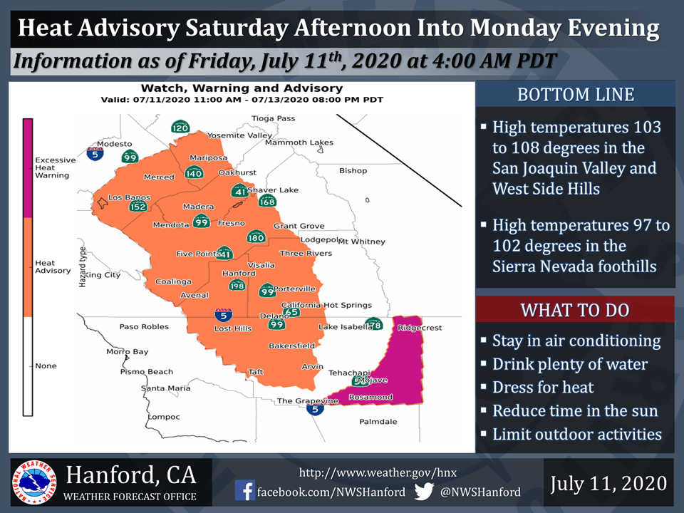
July 11, 2020 - The National Weather Service Hanford Office reports a Heat Advisory is in effect for the San Joaquin Valley, West Side Hills, and Sierra Nevada foothills from 11:00 A.M. Saturday morning until 8:00 P.M. Monday evening.
Heat sensitive people and those who are new to the area will be most prone to heat illness.
Dehydration and prolonged exposure or strenuous physical activity outdoors could lead to heat exhaustion and/or heat stroke.
If you have to be outside, apply sunscreen, stay hydrated, and wear light colored, loose fitting clothing.
  Area Forecast Discussion
  National Weather Service Hanford CA
  400 AM PDT Sat Jul 11 2020


  .SYNOPSIS...
  A strong ridge of high pressure over the Desert Southwest will
  bring widespread triple digit heat to the San Joaquin Valley,
  lower foothills and Kern County desert through Monday. The ridge
  will weaken some next week but temperatures will remain a little
  above normal with continued dry weather.

  &&

  .DISCUSSION...
  Satellite loops show clear skies over the central California
  interior this morning as anticyclonic flow prevails over the
  region. A strong ridge of high pressure aloft centered over
  New Mexico brought widespread triple digit heat to the lower
  elevations on Friday with max temperatures around 3-5 degrees
  above normal. The upper ridge will build westward over southern
  California today bringing further warming to the district. The
  ridge holds strong through Sunday with perhaps another degree
  or two of warming. By Monday the ridge is expected to weaken
  a bit as an upper trough moves over the Northwest. This will
  lower temperatures slightly, but temps are still expected to
  be several degrees above normal. These conditions from today
  through Monday will pose a moderate to high heat risk for the
  population with Sunday forecast to be the hottest day. A Heat
  Advisory is in effect for the San Joaquin Valley, the Sierra
  Nevada Foothills, and the West Side Hills today through Monday.
  High temperatures are forecast between 100-109 degrees for the
  SJ Valley and from 95-105 degrees in the adjacent foothills. An
  Excessive Heat Warning is in effect for the Indian Wells Valley
  and Kern County Desert today through Monday. High temperatures
  there are forecast between 104-113 degrees. The hottest areas
  are forecast to have very high heat risk on Sunday, especially
  across the Indian Wells Valley. Area rivers and streams might
  seem very inviting to cool off from the heat, but they can be
  extremely dangerous too. The waters are still cold and swift
  and venturing into them can result in drowning or water rescue.

  The center of the ridge gets displaced over West Texas Tuesday
  and remains there the rest of next week. Temperatures lower a
  few more degrees on Tuesday then little changes through Friday.
  High temperatures across the SJ Valley look to hover within a
  couple degrees either side of the century mark next Tues-Fri,
  around 2-5 degrees above normals for mid July.

  Moisture wrapping around the anticyclone could bring a few mid
  and high clouds at times this weekend, but expect mainly sunny
  skies to prevail. The models are suggesting a weak disturbance
  could set up just off the central CA coast on Wednesday and may
  linger through the end of the week. We could begin to see some
  afternoon cumulus development over the Sierra Nevada Wednesday,
  but no thunderstorms are forecast at this time.
Source: NWS

