


Includes Yosemite National Park
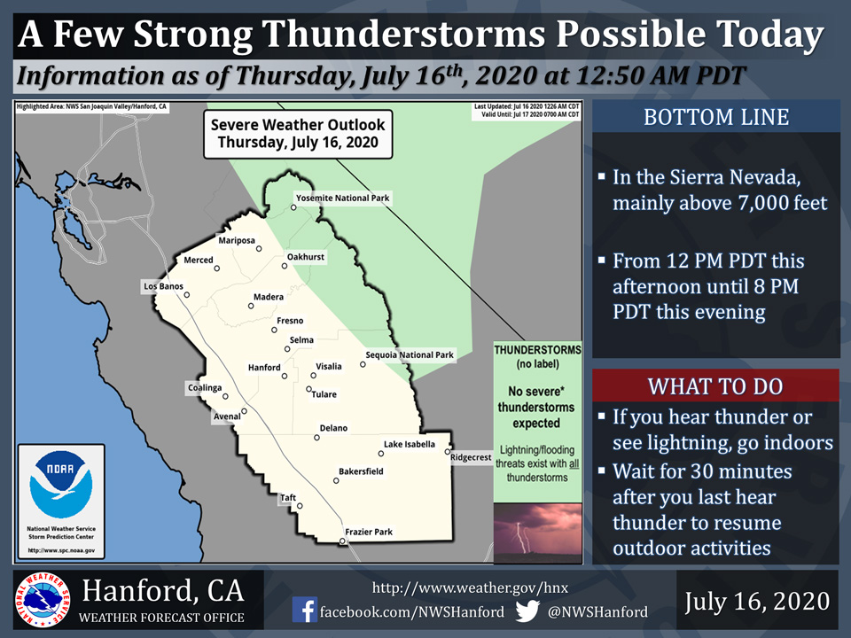
July 16, 2020 - The National Weather Service Hanford Office reports a few strong thunderstorms are possible in the Sierra Nevada, mainly above 7,000 feet this afternoon into this evening.
Small hail, funnel clouds, and wind gusts near 40 miles per hour are some of the hazards associated with strong thunderstorms.
In addition to dangerous cloud to ground lightning strikes, any thunderstorm can produce intense rainfall rates, leading to localized flooding.
  Area Forecast Discussion
  National Weather Service Hanford CA
  242 AM PDT Thu Jul 16 2020

  .SYNOPSIS...
  A few strong thunderstorms are possible this afternoon and Friday
  afternoon in the Sierra Nevada, mainly above 7,000 feet.
  Widespread triple digit heat will impact the San Joaquin Valley,
  West Side Hills, and Kern County desert this weekend. High
  temperatures may eventually return to seasonal values by the
  middle of next week.

  &&

  .DISCUSSION...
  An upper-level area of low pressure will be located just offshore
  of Southern California today through Friday morning. This cyclone
  aloft will retrograde westward Friday afternoon and Friday night.
  A ridge of high pressure will build westward over California this
  weekend. A few strong thunderstorms are conceivable this afternoon
  into this evening in the Sierra Nevada, mostly above 7,000 feet. A
  few strong thunderstorms are possible Friday afternoon along the
  Sierra Nevada crest. A thunderstorm or two cannot be ruled out
  Saturday afternoon along the Sierra Nevada crest. Maximum
  temperatures this afternoon will be two to three degrees warmer
  than yesterday. Widespread triple digit is expected in the San
  Joaquin Valley, West Side Hills, and Kern County desert this
  weekend. High temperatures throughout Central California Saturday
  afternoon and Sunday afternoon will be around five degrees above
  normal for this time of year.

  The aforementioned ridge of high pressure will remain in place
  Monday and Monday night. A trough of low pressure may approach the
  coast of California Tuesday. This trough of low pressure could
  move inland Tuesday night or Wednesday. The presence of the trough
  of low pressure may allow temperatures to return to seasonal
  values by the middle of next week. At this time, it does not
  appear as if monsoonal moisture will move into the Kern County
  desert next week.

  &&

  .AVIATION...
  Smoke emanating from the Mineral Fire may persist in a layer at
  or above 6,000 feet, especially in Merced County, Kings County,
  and the western portions of Fresno and Madera Counties. Mountain
  obscurations are possible in the Sierra Nevada, mainly above 7,000
  feet from 19Z this afternoon until 03Z Friday due to isolated
  showers and thunderstorms.
Source: NWS

