


California and National Drought Summary for July 14, 2020
Summary
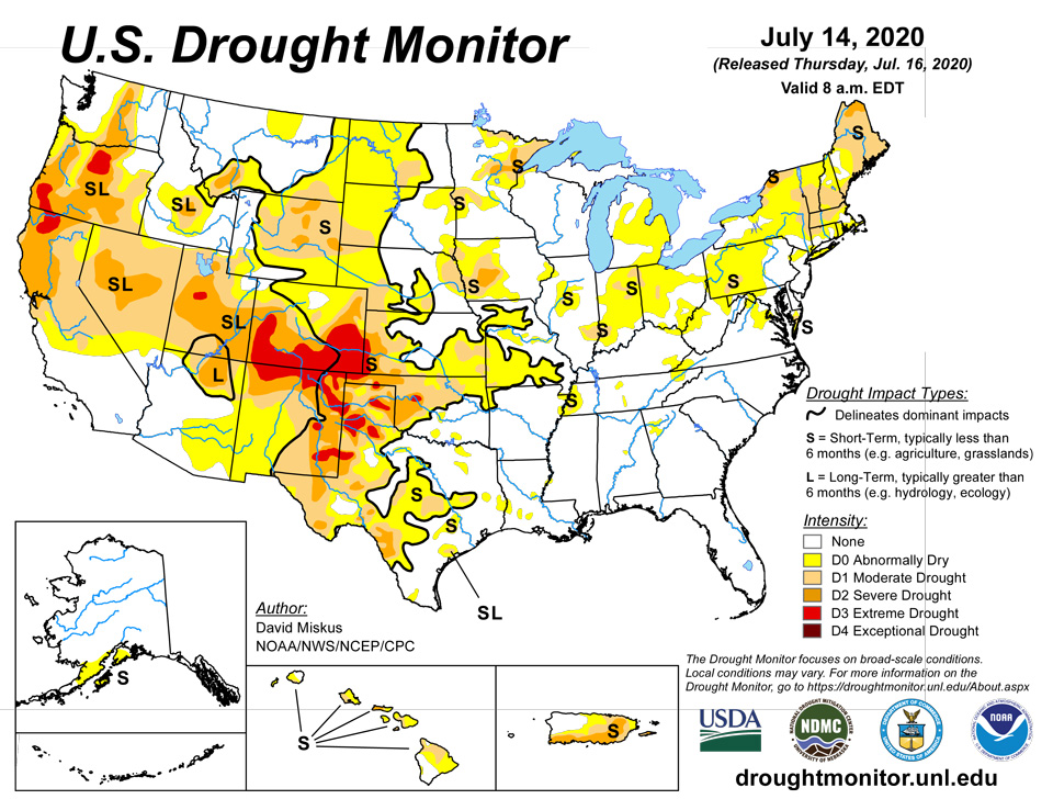
July 16, 2020 - The active Atlantic hurricane season continued (with respect to number of named storms) as minimal Tropical Storm Fay formed off the Carolina coast, moved northward, and made landfall in New Jersey. Rainfall from Fay was beneficial for parts of the Northeast, especially the Delmarva Peninsula, New Jersey, eastern Pennsylvania, and western New York, where 2-3 inches of rain, locally to 7 inches, brought widespread relief from growing short-term dryness and drought. Lighter totals also fell on most of New England, but most areas did not receive enough rain to make any marked improvements. Elsewhere, a series of slow-moving fronts drifted across the lower 48 States, generating MCCs (Mesoscale Convective Complexes) with swaths of decent rain across parts of the central Plains, Midwest, and Southeast. Several fronts produced scattered but heavy thunderstorms across the upper Midwest. Unfortunately, many areas received little or no precipitation this week, including much of the West (from the Rockies to the Pacific Coast), the southern Plains, lower and middle Mississippi River Valleys, and most of the Appalachians and Piedmont. Unfortunately, the dryness was accompanied by excessive heat (weekly temperatures averaged more than 4 degrees F above normal) in the southwestern and northeastern quarters of the Nation. For example, Borger, TX, set an all-time record high of 116 degrees F on July 11. The combination of heat and minimal rainfall was a concern for many agricultural areas as crops are at critical stages of growth and reproduction, and with high evapotranspiration rates during the summer heat, topsoil moisture can become rapidly depleted and stress the crops. In contrast, the Northwest recorded subnormal temperatures (2 to 6 degrees F below normal), along with some light precipitation in northernmost regions. In Alaska, light to moderate precipitation fell on southern, central, and southeastern sections, while Hawaii saw some windward showers early in the period but not enough for any improvement. Heavy rains (2-5 inches) fell again on non-drought portions of northwestern Puerto Rico and along eastern sections (2-6 inches), slightly trimming away some of the D2 there.
Northeast
Tropical Storm Fay brought welcome rainfall (2-3 inches, locally to 7 inches) to parts of the Northeast, particularly the Delmarva Peninsula, New Jersey, eastern Pennsylvania, and western New York, which had been trending dry. Unfortunately Fay did not bring beneficial moisture to much of New England, but other systems dropped light to moderate totals (1 to 3 inches) on parts of central New Hampshire and western Maine. Combined with an increase in precipitation the previous 2 weeks, some 1-category improvements were made to those two areas, and of course to locations where rainfall from TS Fay removed short-term deficits (areas mentioned earlier). In contrast, some Northeastern locations were dry this week, and some slight expansion of D0 or drought was made. This included D0 in eastern Connecticut, D0 in parts of northern and western West Virginia, and D0 and D1 in the extreme southern portion of the Delmarva Peninsula which completely missed rain from Fay. USGS 7-day averaged stream flows have responded to the rains, with above (76-90) to much-above (>90) percentiles common in New Jersey, eastern Pennsylvania, south-central New York, central New Hampshire and western Maine. In contrast, flows remain low (<25th percentile) in the rest of Maine, eastern upstate New York, western Massachusetts and Connecticut, and western Pennsylvania. According to NASS/USDA, percent short to very short topsoil moisture for the week ending July 12 decreased from 19 to 40 percentage points from the previous week where rains from Fay fell.
Southeast
With most areas free of drought and D0 the previous week, the lack of rain across the Appalachians and Piedmont was not too much of a concern. Streaks of light to moderate amounts of rain (1-4 inches) fell across southwestern and north-central Alabama, the western Florida Panhandle, parts of central and southern Florida, west-central and northeastern South Carolina, and southeastern North Carolina. The small D0 in central Alabama (Shelby County) received 1-2 inches of rain across its northern portion, enough to shrink the D0 area in size. However, a few small areas had accumulated short-term (60-90 days) deficits, and with this dry week, D0 was added in northern and southwestern Virginia, Virginia’s Delmarva Peninsula (D1 also), and northwestern Georgia. Overall topsoil moisture, hydrologic, and agricultural conditions are doing well across the Southeast, but a few weeks of dry and warm weather during the growing season can quickly change things. For example, a month ago, southwest Virginia was incredibly wet, but after June 19, the rains nearly stopped. For the 3-week period ending July 12, Roanoke, VA, had 0.17” (but 7.56” June 1-19; 11.44” for May; 5.84” for April).
South
Similar to the Southeast, decent rainfall was generally lacking except for a few areas. Unexpected moderate to heavy (1-3 inches, locally to 6 inches) rains from a couple of MCCs fell on the south-central Great Plains (central Kansas and eastern half of Oklahoma), providing some relief from drying conditions. Tulsa, OK, measured only 0.11” of rain in June, but has 4.00” the first 13 days of July. The rains also ended excessive heat over the weekend when Borger, TX, set its all-time highest reading at 116 degrees F on July 11, and numerous Oklahoma sites exceeded 115 degrees F for their heat index (two sites hit 120 degrees F). Heavy (1.5-5 inches) rains also fell on west-central Tennessee, but mostly missed the three small D0 areas of western and central Tennessee. Accordingly, the D0 in western Tennessee expanded, along with a new D1 area near Memphis, and a new D0 in northeastern Tennessee. Scattered light amounts (inch or less) were observed in the Texas Panhandle, across central and east-central Texas, most of Louisiana and Arkansas, and the southern two-thirds of Mississippi. In contrast, little or no rain combined with excessive heat (weekly temperatures averaging 4-10 degrees F above normal) exacerbated conditions in southwestern Texas, the Texas and Oklahoma Panhandles, and much of New Mexico. According to USDA/NASS for the week ending July 12, topsoil moisture short to very short (in parentheses) gained percent points from the past week in Texas (67%), Louisiana (20%), Arkansas (35%), Tennessee (29%), and Mississippi (14%), but dropped in Oklahoma (45%) as expected with the widespread rains. Not surprising, July 12 crop conditions in Texas rated very poor or poor was: corn (12%); cotton (41%); sorghum (22%); peanuts (17%); oats (22%); and pastures and ranges (39%). South Texas remained wet at 60-days and beyond, but continued lack of rain and heat should soon start taking a toll on the soil moisture and agriculture.
Midwest
Just like the Southeast and South regions, the Midwest also saw areas with heavy rains, and others with nothing. Unfortunately, a big concern was short-term (30-days) dryness combined with above-normal temperatures and evapotranspiration (creating high weekly EDDI values) during the critical time for crop growth and pollination. In addition, some states have vulnerable soil characteristics (e.g. sandy, high clay, or shallow rocky) to flash drought situations. With respect to rainfall, light to moderate totals (1-3 inches, locally to 6 inches) fell on portions of the upper Midwest (Minnesota and Wisconsin), and parts of the Ohio Valley (east-central Illinois, southwest Indiana, western Kentucky, eastern Ohio) where improvements were made if totals were significant (>2 inches). However, little or no rain was measured in the southern half of Iowa, much of Missouri, western Illinois, and scattered locations in eastern Kentucky, central Indiana, central Ohio, and northern lower Michigan. Accordingly, D0 was expanded in parts of Ohio, Michigan, Missouri, and Iowa, with D1 developing in portions of Ohio, Indiana, and Illinois, and expanding in western Iowa. USDA/NASS crop conditions as of July 12 rated poor or very poor have reached or surpassed 10% for corn in Indiana and Ohio, and soy in Illinois, Indiana, and Ohio. Although some light scattered showers fell on lower Michigan and there is a wet signal at 60-days and beyond, recent excessive heat produced very high ET rates (and high QuickDri and EDDI values). This heat impacted Michigan’s corn and soybeans, with July 12 crop conditions rated poor or very poor at 17% and 13%, respectively, with pastures similarly rated at 28%.
High Plains
Northern and western states had seen an improvement trend the past several weeks as wetter and cooler conditions have gradually eased drought and dryness from Montana and the Dakotas. However, southern states have seen a gradual deterioration this summer, with some or most of Wyoming, Colorado, Nebraska, and Kansas in drought (D1 or drier). Fortunately, several MCCs formed in the north-central and central Plains this week, bringing welcome rainfall (1-3 inches, locally 5 inches) to southern South Dakota, central Nebraska, and central Kansas. As a result, some D0 was removed from northern and eastern Montana, southwestern South Dakota, and parts of central Nebraska and Kansas. D1 was improved to D0 in northern and western North Dakota, southwestern South Dakota, northeastern Nebraska (but expanded into eastern Nebraska and western Iowa), and southeastern Kansas. Lighter amounts (an inch or less) also fell on northern and eastern Montana, most of the Dakotas and Nebraska, northeastern Colorado, and most of Kansas. However, high heat negated the effects of the rain in the southern and central High Plains, causing expansion of D0 and drought (D1-D3) in much of Colorado, southern Wyoming, western Nebraska, and western Kansas. According to USDA/NASS on July 12, topsoil moisture rated short to very short was at 74% (WY), 60% (CO), 47% (NE), 45% (KS), and under 25% in the Dakotas and Montana. Similarly, pasture and range conditions rated poor to very poor was 44% in Colorado, 36% in Wyoming, 22% in Kansas, and 18% in Nebraska. Montana and the Dakotas were also in the teens, but these numbers have fallen (improved) the past few weeks in response to the favorable weather.
West
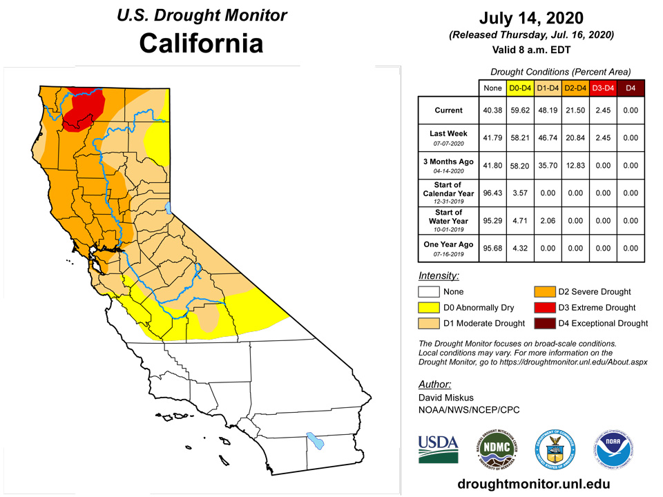
Dry weather prevailed across much of the West, with the southwest monsoon yet to arrive in the Southwest. While temperatures averaged near or below normal in the northern half of the region, above to much above normal readings baked parts of the Southwest, southern Rockies, and southern High Plains. With the late start to the summer monsoon and oppressive heat, deteriorations were made in New Mexico, Colorado, southern Nevada, southwest Utah, parts of central coastal California, and portions of Oregon. In New Mexico, the combination of extreme heat stress and high ET on what rain that had fallen over the past few weeks included coverage of D0 in southwestern sections, D1 expansion in central and southeastern portions, and some D3 increase in the northwest, northeast, and southeast. Field reports indicated ranchers selling cattle, cutting yearlings off due to no grass, and feeding cake cubes and buying hay. In California, D1 was extended across Santa Clara County and Santa Cruz Mountains due to significant drying of fuels, while southern Nevada went to D1 from D0 due to short-term impacts, lack of WY precipitation, and recent wildfire activity. In Oregon, WYTD SPIs suggested expanding D3 areas as well as field reports for stream flows and soil moisture drying out. In Klamath County, widespread ag, livestock, and surface water impacts necessitated a downgrade to D2.
Alaska, Hawaii, and Puerto Rico
In Alaska, light to moderate precipitation (0.5-2 inches, locally to 5 inches) fell on southern, central, and southeastern sections. The rainfall was enough to trim away some of the western D0 edge in central Bristol Bay Lake and Peninsula County, but the remaining D0 was left as totals were much less (0 to 0.5 inches).
Windward areas received some rainfall while leeward sides saw little or no rainfall - as expected this time of year. On Kauai, subnormal rainfall totals and NDVI data supported the expansion of D1 along the lower southern slopes of the island. On Maui, the central valley remained quite dry, which was highlighted by a wild fire near Haliimaile southeast of Kahului that took a couple of days to contain. Rainfall and NDVI supported expanding the current leeward D1 to include the entire central valley. The rest of the state was unchanged.
On Puerto Rico, the northwestern portion of the island continued to receive moderate to heavy (2 to 6 inches) rains, increasing 60-days surpluses up to a foot in some locations. In eastern sections, 2-4 inches of rain fell, improving D2 to D1 in Las Piedras and Rio Grande provinces, although some large 60-day deficits still remained. Elsewhere, enough light rain fell to keep conditions unchanged.
Pacific Islands
The weather across the U.S.-Affiliated Pacific Islands (USAPI) during this USDM week (7/8/20-7/14/20) was dominated by an Inter-Tropical Convergence Zone (ITCZ), which developed between the equator and 10 degrees North latitude, and Tropical Upper Tropospheric Troughs (TUTT cells) or upper-level lows mostly north of 10N. The ITCZ was accompanied by, comprised of, or dissolved into surface troughs, trade-wind convergence, and tropical disturbances at various times during the week. Convection generated by the surface convergence was enhanced by divergence aloft associated with the TUTT cells, especially over western Micronesia. The TUTT-enhanced convection over the Marianas worked in opposition to a dry season trade-wind regime which still wanted to exert influence. South of the equator, convergence/convection associated with low pressure, shear line trough, and a frontal boundary won the battle against a drier and more stable airmass over the Samoan Islands.
Satellite-based estimates of 7-day precipitation (QPE) showed a continuous band of 1+ inches of rain, with embedded areas of 4+ inches, stretching across Palau, the Federated States of Micronesia (FSM), and Marshall Islands (RMI), from the equator to about 8 degrees N in western Micronesia to about 2 to 10 degrees N in the east. Areas of 2+ inches of rain hop-scotched across the far northern Marianas. Another band of 2+ inches of rain extended southeastward from Indonesia toward the Samoan vicinity as the South Pacific Convergence Zone (SPCZ). But the SPCZ rain band broke up into separate cells over the Samoan Islands.
This week the Republic of Palau remained free of drought or dryness as Palau IAP received 2.16 inches, while Koror COOP received 1.96 inches, meeting the 2-inch weekly minimum for most water needs.
The Mariana Islands remained relatively dry with Rota at D3-SL and Saipan at D4-SL, but Guam did receive 1.77 inches, warranting improvement to D0-SL. May rainfall greened up vegetation on Guam, but conditions were still dry, although no fires were noted. Rainfall at Rota was 0.91 inches. Saipan received 0.60 in the manual gauge, 0.52 inches at Saipan ASOS, and 0.99 inches at Saipan NPS. The Mariana Islands require an inch of rain to meet most weekly water needs.
Precipitation was rather variable over the Federal States of Micronesia. More than 2 inches of rain fell, meeting most weekly water needs, at Woleai (3.87), Nukuoro (3.38), Lukunor (2.14), Kosrae (2.12) and Pingelap (2.00). Ulithi received 2.28 inches, allowing for the removal of D0. Some locations received less than 2 inches, including Fananu (1.98), Kapingamarangi (1.85), Pohnpei (1.83), Chuuk (1.42), and Yap (1.11). On Kapingamarangi, which remained at D2-S, household storage water tanks were at 25 percent of capacity, and plants were yellowing and browning. Fananu remained at D0-S.
Precipitation was ample for much of the Republic of the Marshall Islands, where 2 inches weekly is sufficient to meet most water needs. Kwajalein received 4.85 inches, leading to improvement from D1-SL to D0-SL. Other locations receiving more than 2 inches included Ailinglapalap (3.94), Mili (2.40), and Jaluit (2.07). Locations receiving less than 2 inches were Majuro (1.38) and Wotje (1.11), which remained at D3-SL. On Kwajalein, vegetation remained the same greenish-brown, but will likely improve, given this week’s rain. Data was missing for Utirik.
American Samoa had adequate rainfall this week, and Tutuila remained free of dryness. Pago Pago received 2.08 inches, Siufaga Ridge NPS received 4.20 inches, and Toa Ridge received 2.69 inches.
Virgin Islands
Radar-based estimates of rainfall for the 7 days ending at 12z on Tuesday in the U.S. Virgin Islands showed largely 1+ inches of rain across St. John and St. Thomas. Rainfall across St. Croix decreased from 1+ inch on the southwestern end of the island to no precipitation on the eastern end.
St. Croix remained at D3-SL this week as rainfall at Henry Rohlsen AP amounted to 0.39 inches, which was below normal. The CoCoRaHS station at Christiansted 1.8 ESE reported 0.40 inches, while Christiansted 4.1 ESE reported only 0.06 inches. The UVI sheep research facility reported 1.09 inches for the week. The USGS Adventure 28 well reported no data due to equipment malfunction.
St. Thomas remained at D2-S. Precipitation at Cyril E. King AP was 1.22 inches, or above normal. The CoCoRaHS stations at Charlotte Amalie 1.4 NE and Anna's Retreat 2.5 ESE reported 1.13 and 1.25, respectively. The Charlotte Amalie 5.1 E station reported just 0.16 inches. The Grade School 3 Well rose nearly one foot from last week and was about 11.29 feet below land surface, following rain this week.
St. John remained at D3-S for the week. The Windswept Beach CoCoRaHS station reported 0.72 inches, while 0.45 inches fell at the CoCoRaHS station at Cruz Bay 0.8 NE, and 0.76 inches was reported at the CoCoRaHS station at Cruz Bay 1.6 E. There was no data from the USGS Susannaberg DPW Well, due to equipment malfunction.
Looking Ahead
During the next 5 days (July 16-20), WPC’s QPF forecasts light to moderate (1 to 3 inches) rains across the middle Mississippi River Valley, upper Midwest, and southern Florida. Lighter totals are expected in the southern Rockies and south-central High Plains, along the central Gulf Coast, and in the Appalachians. Little or no rain is anticipated in the West, southern Plains, portions of the Southeast, and along the Northeast Coast. Most of the lower 48 States should expect above-normal temperatures, with subnormal readings limited to the northern Plains.
The Climate Prediction Center’s 6-10 day outlook (July 21-25) favors above-normal rainfall across the northeastern quarter of the contiguous U.S., along the western Gulf Coast, in Arizona and Utah, and in western Alaska. Odds for subnormal precipitation are likely in the Pacific Northwest, the central Plains, and along the southern coast of Alaska. A tilt toward above-normal temperature probabilities were found across much of the lower 48 States and along Alaska’s southern coast, but highest odds were found in the central Plains and northeastern quarter of the Nation. Subnormal readings were limited to the northern two-thirds of Alaska.
Author(s):
David Miskus, NOAA/NWS/NCEP/CPC
Denise Gutzmer, National Drought Mitigation Center
Dryness Categories
D0 Abnormally Dry—used for areas showing dryness but not yet in drought, or for areas recovering from drought.
Drought Intensity Categories
D1 Moderate Drought
D2 Severe Drought
D3 Extreme Drought
D4 Exceptional Drought
Drought or Dryness Types
S Short-Term, typically less than 6 months (e.g. agricultural, grasslands)
L Long-Term, typically greater than 6 months (e.g. hydrologic, ecologic)
Source: National Drought Mitigation Center

