


California and National Drought Summary for July 21, 2020
Summary
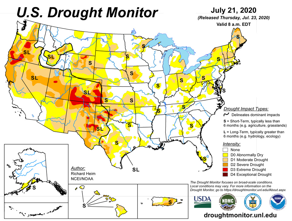
July 23, 2020 - High pressure dominated the southern half of the contiguous U.S. (CONUS) during this U.S. Drought Monitor (USDM) week. Upper-level weather systems tracked across the U.S.-Canadian border, dragging surface lows and fronts along with them. The frontal systems tapped Gulf of Mexico moisture to drop locally heavy rain across parts of the Plains to Midwest, while convective thunderstorms peppered coastal areas of the Gulf. The high-pressure ridge inhibited precipitation across much of the southern Plains to Southeast, and across most of the West. It also kept temperatures unusually hot, with daily maximums exceeding 90 degrees F across the South throughout the week and across much of the West for most of the week. The excessive heat spread into the northern Plains, Midwest, and into the Northeast as the week wore on. The persistent heat increased evapotranspiration, which dried soils and stressed crops and other vegetation. The locally heavy rains brought temporary relief from the heat and dryness, but only for those areas in the Plains and Midwest lucky enough to receive the rain.
Northeast
Half an inch to locally more than 2 inches of rain fell from northwestern Pennsylvania to parts of Maine, while coastal areas of the Northeast received smaller amounts. Moderate drought expanded in parts of Pennsylvania and Maryland. No change in the drought status occurred across the rest of the region, with abnormal dryness and moderate to patches of severe drought continuing.
Southeast
Convective storms peppered parts of the Gulf Coast and North Carolina with half an inch to locally over 2 inches of rain. But the showers were scattered and mostly hit or miss. Moderate drought was introduced in northern Virginia where persistent dryness and heat were taking their toll on crops. Areas of abnormal dryness were added to Alabama, Georgia, Florida, South Carolina, and other parts of Virginia.
South
Two to locally over 5 inches of rain fell across parts of the Texas panhandle and northwest Oklahoma, and along parts of the Texas to Mississippi coast. But it was another dry week across much of Texas to eastern Oklahoma to northern Mississippi and Tennessee. Moderate to extreme drought contracted in the wet panhandles of Texas and Oklahoma, but moderate to severe drought expanded in other parts of Texas, with pockets of extreme drought added to southwestern Texas and southwestern Oklahoma. Abnormal dryness or moderate drought expanded further east across parts of Arkansas, Louisiana, and Tennessee.
Midwest
Two or more inches of rain spread across northern Missouri and southern Iowa, swathed Illinois into Indiana, and stretched across parts of Minnesota to Michigan. But other parts of Iowa, Minnesota, eastern Indiana, and especially Ohio missed out on the rain. Thunderstorms peppered Kentucky, except in the southeast. Drought and abnormal dryness contracted in northern Minnesota, northern Missouri to southern Iowa, and parts of Illinois, but expanded in northwestern Iowa, southern Missouri, central Illinois, southeastern Michigan, parts of Indiana, eastern Kentucky, and especially across Ohio.
High Plains
Areas of 2+ inches of rain were widespread across Kansas, eastern North Dakota, and parts of Nebraska, with locally over 5 inches in northeast Kansas and southeast Nebraska. But the spigot remained off across most of Wyoming and western and northern parts of Colorado. Drought contracted where the beneficial rains fell, including southeast Colorado, western Kansas to parts of Nebraska, northeast Wyoming, and parts of North Dakota. But drought and abnormal dryness expanded where it continued dry, including eastern Kansas, northeastern Colorado to adjoining parts of Nebraska, northeastern Nebraska, parts of the Dakotas, and especially in Wyoming. Moderate to severe drought expanded in, and extreme drought was added to, Wyoming.
West
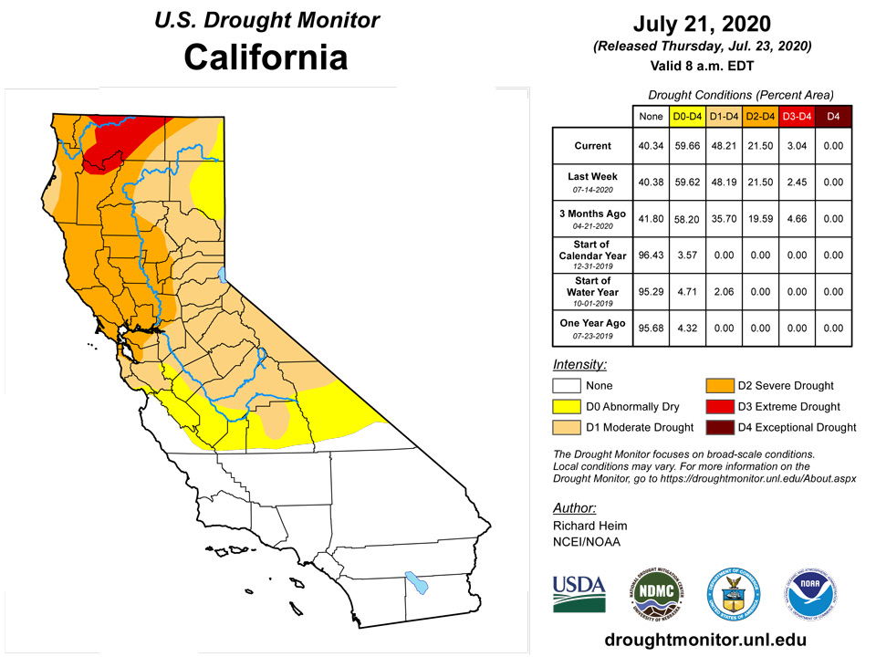
Eastern Montana and parts of New Mexico received notable amounts of rain (half an inch or more), with scattered light showers over parts of Arizona, but most of the West was bone dry this week. Drought or abnormal dryness contracted in northeastern Montana and parts of eastern and southern New Mexico. But the weak Southwest Monsoon otherwise left the Four Corners States bereft of significant rainfall, so drought and abnormal dryness expanded in central, western, and southern New Mexico; across much of Arizona; and in parts of Nevada, Utah, and Oregon.
Alaska, Hawaii, and Puerto Rico
With widespread 2+ inches of rain, and locally 5+ inches, over much of western Puerto Rico, drought improved in the southwestern part of the island. But abnormal dryness to severe drought continued in the southern and central to eastern portions. Windward areas of the Hawaiian Islands have been getting some trade wind shower activity, but overall precipitation has been below average. Drought expanded where pasture and vegetation conditions deteriorated and water departments requested the public to reduce water consumption. No change was made to the depiction in Alaska.
Pacific Islands
This was a dry week for Koror, Palau, receiving only 0.38 inch of rain. The month-to-date precipitation is only 4.52 inches. Since June 2020 was an extremely wet month, drought free conditions remain in Palau for another week.
For a second consecutive week, Guam had wet conditions with 2.47 inches of rain. Month-to-date rainfall total is 4.73 inches, which is a little more than the monthly threshold of 4 inches to meet most water needs. For this reason, drought classification for Guam was changed to drought free conditions. Saipan had close to 1 inch of rain this week, while Rota had only 0.59 inch of rain. With the month-to-date rainfall total below the 4-inches threshold for both locations, Rota’s drought classification remains in extreme drought, while Saipan is in exceptional drought this week.
Wet conditions were present across most stations across the Federated States of Micronesia. Chuuk Lagoon, Pohnpei, Kosrae, Fananu, Lukunoch, Nukuoro, and Ulithi had close to or over the 2 inches threshold to meet most water needs. Meanwhile, Yap, Nukuoro, Pingelap, Kapingamarangi, and Woleai had over 1 inch of rain. All of these locations, with the exception of Fananu and Kapingamarangi, remained in drought free conditions. Fananu remains in abnormally dry conditions since the month-to-date rainfall total is less than 8 inches at 5.50 inches. Kapingamarangi’s month-to-date rainfall total is only 3.88 inches, securing another week of severe drought.
Most stations across the Marshall Islands continued to be free of drought as they had another wet week. Mili and Majuro had the most rain at 6.22 and 5.48 inches, respectively. Jaluit had over 3 inches of rain, meanwhile Ailinglapalap (1.77 inches) and Kwajalein (1.65 inches) had over 1.5 inches of rain. Kwajalein remained in abnormally dry conditions since the monthly threshold of 8 inches hasn’t been met in the last few months, while the rest of the locations were drought free. Wotje had 1.21 inches of rain. The month-to-date total is 2.32 inches. For this reason, extreme drought persists across Wotje.
After receiving over 3 inches of rain this week, Tutuila remains in drought free conditions.
Virgin Islands
Precipitation totals ranged between 0.23-0.45 inches of rain across the USVI. St. Thomas airport had only 0.43 inch of rain and 0.44 inch at Anna's Retreat 2.5 ESE CoCoRaHS station. The month-to-date and year-to-date values are 120.9% and 83.1%, respectively, at the airport. SPI values for St. Thomas ranged between drought free and abnormally dry conditions. Similarly, St. John had 0.35-0.45 inches of rain, depending on the different CoCoRaHS stations. SPI ranged between drought free to severe drought. St. Croix precipitation was only 0.40 inch of rain at the airport, while 0.23 inch fell at the Christiansted 1.8 ESE CoCoRaHS station. The airport's month-to-date and year-to-date rainfall totals at the airport were 85.6% and 78.6%, respectively. Locals in St. Croix reported some improvements in vegetation. Given all of this, one category drought improvement was made to the three locations.
Looking Ahead
For July 23-27, the Southwest Monsoon is predicted to fire up, dropping locally 2 or more inches of rain across parts of the Four Corners states, and up to an inch of rain is forecast over parts of the northern Rockies. Otherwise, the West is expected to be mostly dry. A tropical system may bring up to 4 inches of rain along the western Gulf of Mexico coast and up to 2 inches over southern Florida, while frontal systems could leave one to 3 inches of rain over parts of Nebraska, the northern Plains to western Great Lakes, parts of the Midwest to Appalachians, the Mid-Atlantic coast, and parts of the Northeast. In between these systems, large swaths of the southern and central Plains to Southeast and southern Great Lakes have less than an inch of rain in the forecast. Temperatures are predicted to continue warmer than normal for most of the CONUS. The outlook for July 28-August 1 calls for wetter-than-normal conditions across the Southwest to Mid-Atlantic region and most of Alaska, and drier-than-normal conditions in the Pacific Northwest to Great Basin, northern Plains to Great Lakes, and much of the Northeast, as well as southeast Alaska. Odds favor warmer-than-normal conditions for most of the West, northern Plains to Great Lakes, eastern Gulf Coast, all along the Eastern Seaboard, and across the Aleutians in Alaska. Cooler-than-normal temperatures are likely across the southern to central Plains and across most of Alaska.
Author(s):
Richard Heim, NOAA/NCEI
Ahira Sanchez-Lugo, NOAA/NCEI
Dryness Categories
D0 Abnormally Dry—used for areas showing dryness but not yet in drought, or for areas recovering from drought.
Drought Intensity Categories
D1 Moderate Drought
D2 Severe Drought
D3 Extreme Drought
D4 Exceptional Drought
Drought or Dryness Types
S Short-Term, typically less than 6 months (e.g. agricultural, grasslands)
L Long-Term, typically greater than 6 months (e.g. hydrologic, ecologic)
Source: National Drought Mitigation Center

