


California and National Drought Summary for July 28, 2020
Summary
July 30, 2020 - High pressure dominated the southern half of the contiguous U.S. (CONUS) again during this U.S. Drought Monitor (USDM) week. Upper-level weather systems tracked across the U.S.-Canadian border, dragging surface lows and fronts along with them. The High brought hot temperatures to much of the South, East, and West, with daily maximum temperatures exceeding 90 degrees F every day. The fronts brought cooler temperatures to the Upper Midwest at the beginning of the week, but maximum temperatures began to exceed 90 degrees across the Plains and eastward as the week wore on. The hot temperatures increased evapotranspiration (ET) which dried soils and stressed crops and other vegetation. This was seen in ET models such as the EDDI and ESI and several soil moisture models, satellite observations of soil moisture, and agricultural field reports. As noted by the U.S. Department of Agriculture (USDA) on July 27, 50 percent or more of the topsoil moisture was short or very short (dry or very dry) in states across the Northeast, Midwest, Southeast, southern Plains, southern to central Rockies, and Far West. For the nation as a whole, 37 percent of the topsoil moisture and 35 percent of the subsoil moisture was short or very short, and 30 percent of the pasture and rangeland was in poor to very poor condition. Drought or abnormal dryness expanded or intensified across parts of the West, Midwest, Southeast, and Northeast where little to no rain fell and 30- to 90-day precipitation deficits mounted. But locally heavy rainfall was generated by the fronts in parts of the Plains, Midwest, and East. Heavy rain also fell across southern Texas when Hurricane Hanna struck, and Hurricane Douglas graced parts of Hawaii with beneficial rain. Where the rain fell on drought or abnormally dry areas in these regions, contraction occurred.
Northeast
Over 3 inches of rain fell in southwest Pennsylvania and 2 inches or more occurred in a few parts of New England and West Virginia. But the rain was hit or miss, with large areas receiving less than a quarter of an inch. Contraction occurred in southwest Pennsylvania and parts of Massachusetts and New Hampshire, but abnormal dryness and moderate drought expanded in parts of Massachusetts, Connecticut, Long Island, Pennsylvania, Maryland, and West Virginia.
Southeast
A cool front in northern locations, and afternoon convection in southern locations, brought 2 or more inches of rain to a few parts of Virginia, the Carolinas, and Florida. But most of the rain that fell in the region was localized, with much of the region receiving little to no rain this week. Moderate drought and abnormal dryness contracted in a few parts of Virginia and Florida, but it expanded across other parts of Virginia, in the Carolinas and Alabama, and much of Georgia.
South
Central Oklahoma was inundated with heavy frontal rain while Hanna brought heavy rain to the Gulf Coast from southern Texas to Mississippi. Rainfall exceeded 3 inches in these areas, with locally heavier amounts. Parts of Arkansas, Tennessee, and northern Texas received an inch or more of rain. But little to no rain occurred in a large swath from southwest Texas to western Tennessee and northern Mississippi. Abnormal dryness and moderate to extreme drought contracted, especially in central Oklahoma and the Texas panhandle. Abnormal dryness contracted in parts of Tennessee and Louisiana. But abnormal dryness expanded in parts of eastern Oklahoma and parts of Arkansas, Mississippi, and Tennessee. Abnormal dryness and moderate to extreme drought expanded in other parts of Texas.
Midwest
It was the same story in the Midwest. Bands of heavy showers and thunderstorms moved along the frontal boundary, bringing 2 or more inches of rain locally in Minnesota, Wisconsin, and the Ohio Valley. But soils continued to dry out where it didn’t rain, especially from parts of Iowa to Lower Michigan. Parts of southern Minnesota received over 6 inches of rain, but it mostly fell over areas that were not in drought or abnormally dry. Abnormal dryness to severe drought were reduced in northern Minnesota, and abnormal dryness or moderate drought shrank in parts of Iowa, Missouri, Illinois, Indiana, and Kentucky. But abnormal dryness or moderate drought expanded in Ohio, Michigan, and other parts of Kentucky, and abnormal dryness to severe drought expanded in Iowa.
High Plains
Areas of 2+ inches of rain occurred over parts of Nebraska and Kansas and a few parts of the Dakotas, while parts of Colorado had an inch or more of rain. But little to no rain fell in a few areas of Kansas, across parts of Nebraska and Colorado, across even more of the Dakotas, and across most of Wyoming. Contraction of abnormal dryness and moderate to extreme drought occurred across Kansas and parts of Colorado; abnormal dryness and moderate to severe drought contracted in parts of Nebraska; and abnormal dryness and moderate drought were trimmed in parts of the Dakotas. But abnormal dryness or moderate drought expanded in parts of Colorado and the Dakotas, and abnormal dryness and moderate to severe drought expanded in Nebraska. Wyoming saw expansion of abnormal dryness and moderate to extreme drought. Moderate to extreme drought covers most of Colorado and Wyoming.
West
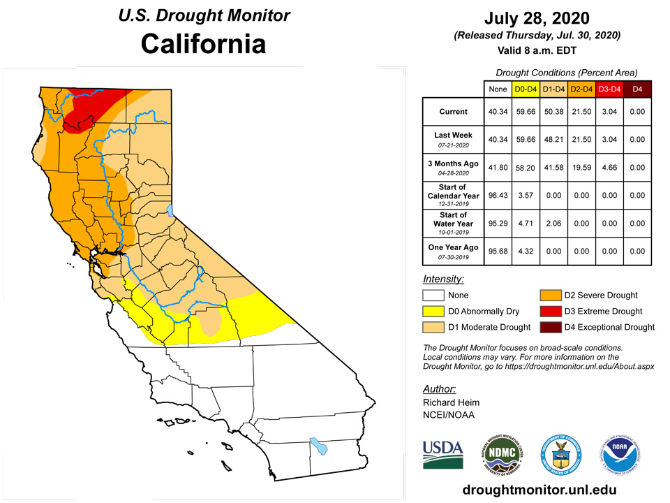
The Southwest Monsoon sparked some showers over New Mexico, with a few showers making an appearance over parts of Arizona, Utah, Idaho, and Montana, but most of the West received little to no rain this week. Severe drought disappeared from southwest Montana, but the rain that fell in New Mexico was not enough to improve conditions there. Severe to extreme drought expanded in New Mexico; moderate to extreme drought expanded in Utah, and Nevada; moderate to severe drought grew in Arizona; abnormal dryness and moderate to severe drought added acres in Montana; and moderate drought expanded in northeast California and adjacent Nevada.
Alaska, Hawaii, and Puerto Rico
Hurricane Douglas brushed Hawaii, bringing rain mostly to windward parts of the islands. A few stations reported 3 or more inches of rain for the week, but amounts varied widely. Abnormal dryness and moderate to severe drought were reduced in parts of the islands, mainly due to improvements in vegetation from leeward rainfall earlier in July. Abnormal dryness and moderate to severe drought were pulled back over parts of southern and eastern Puerto Rico and Vieques Island where 1- to 2-inch rains fell. The rains were enough to raise the level of Lake Loiza on Caraizo Dam. No change was made to the depiction in Alaska.
Pacific Islands
With over 3 inches of rain for the week, Palau remains in drought free conditions.
This was a wet week for the Mariana Islands, with all three locations receiving over their weekly threshold of 1 inch of rain to meet most water needs. Guam had the most rainfall this week at 2.51 inches, securing another drought free week. Saipan had 1.62 inches of rain this week, with a month-to-date rainfall total of 4.35 inches. Since the monthly total surpassed the 4-inches threshold for the month to meet most water needs, a one-category drought improvement was made to Saipan to extreme drought (D3-SL). Even though this was a wet week for Rota, drought conditions remained in severe drought (D3-SL) since the month-to-date rainfall total was still below the threshold of 4 inches.
Most stations across the Federated States of Micronesia had over 1 inch of rain. Pingelap had the most rainfall with nearly 5 inches this week. Ulithi and Woleai had the least rain at 0.57 and 0.27 inch, respectively. Drought free conditions remained across Yap, Chuuk, Pohnpei, Kosrae, Lukunor, Nukuoro, Pingelap, Ulithi, and Woleai since most locations had close to 8 inches of rain or more for the month. Fananu had 2.29 inches of rain this week and 7.79 inches for the month so far. Since Fananu has had close to 2 inches or more of rain the last three weeks, Fananu's drought designation was changed to drought free conditions. Kapingamarangi had 1.13 inches of rain for the week and a month-to-date rainfall total of 5.01 inches. For this reason, Kapingamarangi drought designation of severe drought was unchanged.
This was a dry week for the Marshall Islands, with most stations receiving less than 1 inch of rain. Majuro had the most rain at 1.21 inches this week. Drought free conditions persisted across Ailinglapalap, Majuro, Mili, and Jaluit since these locations had a month-to-date rainfall total close to or over 8 inches. With only 0.79 inch of rain, Kwajalein remains with abnormally dry conditions.
Rainfall totals for Tutuila were 2.01 inches this week, resulting in continued drought free conditions.
Virgin Islands
St. Thomas had only 0.38 inch of rain this week at the Cyril E. King airport and 0.59 inch at the CoCoRaHS station. The month-to-date rainfall total at the airport is 130.5% of normal, while YTD is 86.1% of normal. SPI values ranged between drought free and abnormally dry conditions for the 1, 3, 6, 9, and 12 months. Similarly, St. Croix had only 0.36 inch of rain at the Henry E. Rohlsen airport this week, 0.38 inch of rain at the CoCoRaHS station, and 1.10 at the UVI sheep research facility (17.7160N, 64.7958W) reported. The airport's month-to-date and year-to-date rainfall totals were 76.9% and 77.6% of normal, respectively. SPI values ranged between abnormally dry to moderate drought in East Hill at all months and drought free to moderate drought for the 1,3,6,9 months, and exceptional drought for the 12-month at the airport. St. John had the most rainfall this week at 1.48 inches at the Windswept Beach CoCoRaHS station, 0.88 inch at Cruz Bay 0.8 NE, and 0.45 inch at Cruz Bay 1.6 NE. SPI values at 1, 3, 9, and 12 were typical of drought free to abnormally dry conditions. While the SPI value for 6 months indicated moderate drought. Given all of this, one-category drought improvement was made across the USVI, resulting in St. Thomas having abnormally dry conditions, while St. Croix and St. John have moderate drought.
Looking Ahead
For July 30-August 3, the ridge of high pressure shifts to the West with a trough setting up in the upper atmosphere over the eastern half of the CONUS. Little to no rain is forecast for most of the West, with half an inch or less across parts of the Rockies and only a couple inches stretching across the middle of New Mexico. But an inch or more of rain is expected from the central Plains to southern Appalachians and southern Great Lakes, with heavy rain (4 inches or more) widespread from Missouri and northern Arkansas to Kentucky, Indiana, and western North Carolina. A tropical system is predicted to sideswipe the East Coast, dumping an inch or more of rain across Florida to the Mid-Atlantic states, 3 or more inches over southern Florida, and up to 2 inches over eastern North Carolina and southeast Virginia. Half an inch or less of rain is expected from Texas to southwest Georgia, and across the northern Plains to wester Great Lakes. In the Northeast, predicted precipitation amounts range from nearly 2 inches in western New York to a tenth of an inch along coastal New England. The ridge will keep temperatures warmer than normal in the West while the trough brings cooler-than-normal temperatures to much of the CONUS east of the Rockies. The outlook for August 4-8 calls for a greater than average chance of wetter-than-normal conditions along the East Coast, in the northern Plains, across Deep South Texas, and most of Alaska. Odds favor drier-than-normal conditions across most of the West, the southern Plains, the central Gulf of Mexico coast to the Great Lakes, and over northern Alaska. Warmer-than-normal temperatures are likely across the Southwest and along the immediate East Coast, while cooler-than-normal temperatures are likely to dominate from the Plains to Appalachians, in the Pacific Northwest, and across most of Alaska.
Author(s):
Richard Heim, NOAA/NCEI
Ahira Sanchez-Lugo, NOAA/NCEI
Dryness Categories
D0 Abnormally Dry—used for areas showing dryness but not yet in drought, or for areas recovering from drought.
Drought Intensity Categories
D1 Moderate Drought
D2 Severe Drought
D3 Extreme Drought
D4 Exceptional Drought
Drought or Dryness Types
S Short-Term, typically less than 6 months (e.g. agricultural, grasslands)
L Long-Term, typically greater than 6 months (e.g. hydrologic, ecologic)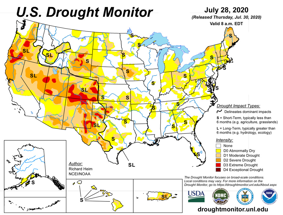
Source: National Drought Mitigation Center
