


Includes Mariposa, Oakhurst and Yosemite Valley
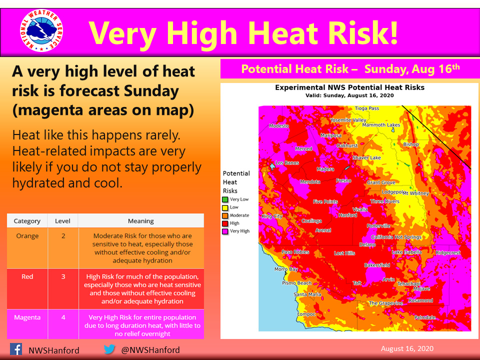
August 16, 2020 - The National Weather Service reports a very high risk for today. Heat events like this are rare for this area. Heat-related impacts are very likely today if precautions are not taken. Plan to take action to reduce time outdoors, drink plenty water, and remain in air-conditioned buildings.
This heat could be deadly for heat-sensitive groups, such as the elderly, young children, and those with chronic ailments.
In addition, this heat may be deadly for those who do not take the proper precautions to avoid heat-related illnesses.
As always, never, ever leave a child or pet in an enclosed automobile.
  Area Forecast Discussion
  National Weather Service Hanford CA
  359 AM PDT Sun Aug 16 2020


  .SYNOPSIS...Dangerous heat will continue across the district
  through majority of the upcoming week. Thunderstorms capable of
  producing flash flooding will be possible over the Southern
  Sierra Nevada, Tehachapi mountains, and Kern County desert this
  afternoon and evening. Otherwise, thunderstorms will pop up near
  the Sierra crest each afternoon through Thursday.

  &&

  .DISCUSSION... With no surprise, we had yet another very hot
  afternoon on Saturday as temperatures across the district soared
  well above the century mark. With a strong 598 decameter high
  centered over the Great Basin, a fair amount of sub-tropical
  moisture was able to advect northward around the periphery of the
  upper high and into the central California interior. This first
  allowed for the unusually humid conditions in the valley, with
  dewpoints reaching into the upper 60`s!! The influx of tropical
  moisture also gave way to an active day of thunderstorms,
  especially over the Tulare and Kern County mountains. As a
  testament to the increased moisture, very heavy rain fell in the
  Frazier Park area where an impressive 1.95" was measured in just a
  one hour period, producing flash flooding in the area. Some of
  these storms made there way into the valley, which produced mostly
  virga and tons of lightning.

  For today, the overall synoptic will be a carbon copy of
  Saturday. First, dangerous heat will continue for the entire
  Southern San Joaquin Valley, West Side Hills, and lower elevations
  of the foothills where temperatures will range between 98 to 112.
  High temperatures in the Kern County desert and Indian Wells
  Valley will range between 105 to 115.

  Another issue today will be the possibility of very heavy rain
  due to afternoon thunderstorms, especially for the Kern County
  desert and the Fort Tejon/Tehachapi areas. The combination of
  above average precipitable water values and decent instability
  (HREF ~500 to 1000 J/kg MUPACES) will lead to a chance of heavy
  rainfall. With weak upper level winds, storms will be slow moving,
  further enhancing the risk of flash flooding. General rainfall
  rates of 0.5" to 1" with higher amounts are possible. In addition,
  with the rain from today the incipient wet conditions will
  enhance the risk of flash flooding, especially in the Frazier Park
  area. Thus, we have coordinated with Oxnard WFO and issued a
  Flash Flood Watch for these aforementioned locations from 11 AM
  until 9 PM tonight.

  Looking into the mid and long range period, the overall synoptic
  pattern does not change much as the strong upper high pressure
  remains over the Great Basin. Growing confidence that the
  dangerously hot temperatures will continue for most of next week.
  Therefore, we have extended the Excessive Heat Warning for all
  locations until Thursday. Lastly, with a continued northward flux
  of sub-tropical moisture around the high pressure, we`ll keep the
  daily risk of afternoon thunderstorms over the higher elevations
  of the Sierra through at least Thursday.
Source: NWS

