


Includes Mariposa, Oakhurst and Yosemite Valley
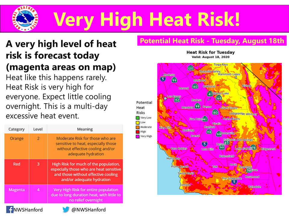
August 18, 2020 - The National Weather Service Hanford Office reports near record heat will continue to impact the San Joaquin Valley, Sierra Nevada foothills, West Side Hills, and Kern County desert, resulting in a very high heat risk for heat-related illnesses.
Heat events like this are rare for this area.
Heat-related impacts are very likely if precautions are not taken.
Plan to take action to reduce time outdoors, drink plenty water, and remain in air-conditioned buildings.
This heat could be deadly for heat-sensitive groups, such as the elderly, young children, and those with chronic ailments.
In addition, this heat may be deadly for those who do not take the proper precautions to avoid heat-related illnesses.
As always, never, ever leave a child or pet in an enclosed automobile.
  Area Forecast Discussion
  National Weather Service Hanford CA
  311 AM PDT Tue Aug 18 2020

  .SYNOPSIS...
  Dangerous heat will persist across most of Central California
  through at least Thursday. Temperatures will remain above
  seasonal values Friday through Monday. A few strong thunderstorms
  are possible in the Sierra Nevada, Kern County mountains, and Kern
  County desert this afternoon. A few strong thunderstorms are
  conceivable in the Sierra Nevada Wednesday afternoon.

  &&

  .DISCUSSION...
  A large anticyclone aloft will be centered near the Nevada/Utah
  border today through Wednesday. The high temperatures in Fresno
  and Bakersfield this afternoon should fall just short of daily
  record values. Meanwhile, record heat is expected in Merced,
  Hanford, and Madera today. Maximum temperatures Wednesday
  afternoon should fall just short of daily record values at all
  locations. An Excessive Heat Warning remains in effect for the San
  Joaquin Valley, Sierra Nevada foothills, West Side Hills, and
  Kern County desert until Thursday evening. A few strong
  thunderstorms are conceivable in the Sierra Nevada, Kern County
  mountains, and Kern County desert this afternoon. A few strong
  thunderstorms are possible in the Sierra Nevada Wednesday
  afternoon. Strong, gusty west to northwest winds may impact a
  portion of the Kern County mountains and desert Wednesday
  afternoon and Wednesday evening. A Wind Advisory may be required
  for this area.

  The aforementioned, upper-level area of high pressure will shift
  southward Wednesday night. This sizable anticyclonic aloft should
  remain anchored over the Desert Southwest Thursday through Monday.
  Maximum temperatures Thursday afternoon will be about five degrees
  lower than Wednesday afternoon. High temperatures Friday afternoon
  should be around five degrees above normal for this time of year.
  Maximum temperatures Saturday afternoon will be seven to nine
  degrees above their typical values for the latter half of August.
  High temepratures Sunday afternoon and Monday afternoon should be
  around ten degrees above normal for this time of year. A Heat
  Advisory or Excessive Heat Warning may be required for most of
  Central California Saturday through Monday.
Source: NWS

