


Mariposa Weather for Today:
Widespread haze before 4pm. Areas of smoke between 1pm and 2pm. Sunny and hot, with a high near 103. Light and variable wind becoming west 5 to 10 mph in the morning. Winds could gust as high as 20 mph.
Tonight:
Widespread haze before midnight. Areas of smoke before 8pm, then areas of smoke after midnight. Clear, with a low around 73. North wind 5 to 10 mph, with gusts as high as 20 mph.
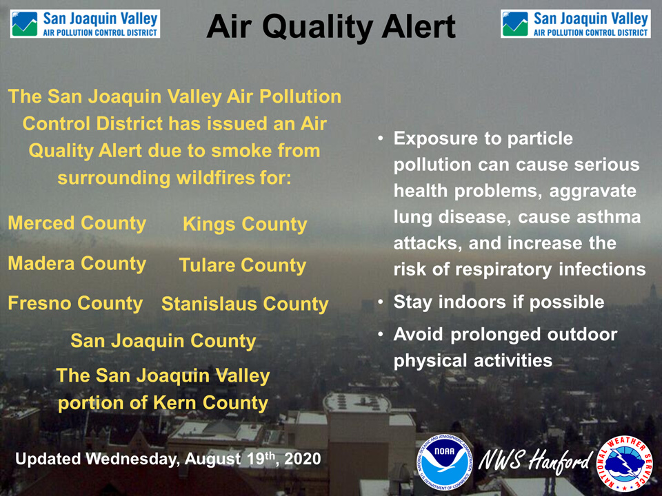
August 19, 2020 - The National Weather Service Hanford Office reports the San Joaquin Valley Air Pollution Control District has issued an Air Quality Alert due to smoke from surrounding wildfires for Merced County, Madera County, Fresno County, Kings County, Tulare County, Stanislaus County, San Joaquin County, and the San Joaquin Valley portion of Kern County.
For additional information, call your local San Joaquin Valley Air District office. Modesto 209-557-6400, Fresno 559-230-6000, Bakersfield 661-381-1809.
Residents can also follow air quality conditions by downloading the free Valley Air app, available in the Apple store or Google Play.
  Area Forecast Discussion
  National Weather Service Hanford CA
  413 AM PDT Wed Aug 19 2020


  .SYNOPSIS...Another dangerously hot day is expected across the
  region. We`ll also have the chance of thunderstorms over the
  higher elevations of the Sierra, and a slight chance of thunder
  over the far eastern portion of the Kern County desert.
  Temperatures will cool down into the weekend, but will remain
  above average.


  &&

  .DISCUSSION...We all get to enjoy yet another dangerously hot day
  across the central California interior as our current heat wave
  continues...Yay!! Afternoon temperatures will be similar to
  Tuesday, with highs between 104 to 109 degrees in the Southern San
  Joaquin Valley and West Side Hills. Temperatures in the Sierra
  foothills will end up between 98 to 103 degrees. Finally,
  temperatures in the Kern County desert will be between 107 to 112
  degrees.

  The HREF indicates that the strong 500mb high pressure that has
  been parked over the Great Basin is beginning to weaken and slowly
  drift southeastward into northern Arizona. Today will feature one
  last good push of subtropical moisture into the region. Also
  there is additional remnant moisture from a dying multicell
  convective system (MCS) currently over San Bernadino County that
  is being pulled around the high pressure into the area. The best
  chances for thunderstorms today will be over the Southern Sierra
  from Fresno County south into Tulare County. This is where the
  best instability and low level moisture exists. Thunderstorms in
  these areas will be capable of heavy rain, hail, and strong
  outflow winds in excess of 40 mph. There is also a slight risk of
  dry thunderstorms over the far eastern portions of the Kern County
  desert, but these will mostly produce strong outflow gusts up to
  40 mph.

  Heading into the weekend, the aforementioned high pressure over
  Arizona will continue to slightly weaken. Additionally, there is
  a deep trough off the Alaskan coast that will dig southward into
  the PacNW. The synoptic cooling from these two features will help
  "cool down" our afternoon high temperatures. However we`ll still
  be near the century mark for most locations, with the exception
  of western Merced which will have more of an influence of cooler
  marine air. The steering flow that has been bringing all this
  subtropical moisture will stay to the east and south, and the
  trough moving into the PacNW will also bring drier air into
  central California. Looking at the long range into next week,
  temperatures will begin to once again increase as the high
  pressure over the desert southwest begins to strengthen.
Source: NWS
