


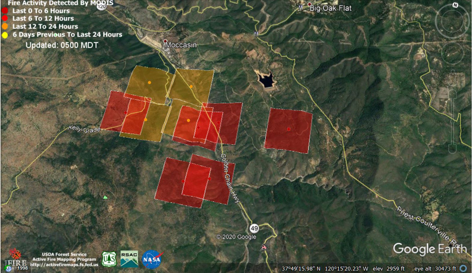
MODIS map of the Moc Fire on Friday at 4:00 A.M. PST
MODIS Active Fire Mapping Program Frequently Asked Questions
Click Here for Saturday Updates
Update: 8:00 P.M. Tuolumne County Moc Fire Friday Evening Update
Updated: 5:30 P.M. 4:20 P.M. 3:30 P.M. Tuolumne County Office of Emergency Services Friday Afternoon Update on the Moc Fire
Updated: 3:35 P.M. Caltrans; State Route 120 W Closed to Through Traffic Due to Moccasin Fire
MONO COUNTY – At the request of Yosemite National Park, Caltrans has closed State Route 120 to through traffic. Vehicles are permitted on SR 120 W in Mono County, however, travel through the park to SR 120 in Tuolumne County is currently restricted. The closure is due to the Moccasin Fire, also known as the Moc Fire, burning west of the park in the Groveland area. Drivers needing to travel west over the mountains should use State Route 108/Sonora Pass or State Route 89/Monitor Pass.
For the latest highway information please visit the Caltrans QuickMap site at quickmap.dot.ca.gov or call the Road Condition Hotline at 1-800-427-ROAD (7623).
Update: 11:30 A.M. CAL FIRE: 2,800 Acres with 0% Containment.8:40 A.M. Mariposa County Sheriff's Office
MOCCASIN FIRE - https://www.fire.ca.gov/incidents/2020/8/20/moc-fire/
8am 8/21/2020
All Mandatory Evacuation and Fire Advisements are still in effect.
Multiple road closures in the area.
Road Conditions:
Open with no restrictions
Greeley Hill (J132) / Smith Station
Closed
Hwy 49N from Penon Blanco to Hwy 120
All North intersecting roads on Greeley Hill Road (J132) / Smith Station from Priest Coulterville to the Mariposa / Tuolumne County Line
For a map of the Evacuation and Fire Advisement Areas- https://arcg.is/0ieeuO
Mandatory Evacuation Area:
The Temporary Evacuation Point for Red Cross and Shelter Information is located at the Mariposa County Fairgrounds 5007 Fairgrounds Rd
4:50 A.M. Friday: Yosemite NPS reports the Moccasin Fire has resulted in the closures of Highways 120 west of Groveland and 49 south of the Hwy 120 junction. Yosemite remains open and is accessible from Groveland. Visitors coming from west of Groveland should use Highway 140.
Caltrans: 120 IS CLOSED FROM 2 MI WEST OF THE SOUTH JCT OF SR 49 /AT JACKSONVILLE RD/ TO 2.9 MI WEST OF GROVELAND /AT OLD PRIEST GRADE RD/ (TUOLUMNE CO) - DUE TO A WILDFIRE - MOTORISTS ARE ADVISED TO USE AN ALTERNATE ROUTE
Click here for Caltrans Road Information
August 21, 2020 - CAL FIRE Thursday evening update on the MOC FIRE: 600 Acres with 0% Containment
| CAL FIRE Incident | Yes |
|---|---|
| Last Updated | 8/20/2020 |
| Date Started | 8/20/2020 |
| Location Information | Hwy 49 and Hwy 120, Moccasin |
| Counties | Tuolumne |
| Acres Burned | 600 |
| Percentage Contained | 0% |
| Administrative Unit | CAL FIRE Tuolumne-Calaveras Unit and Central California District |
| Archive Year | 2020 |
| Status | Active |
| Final | No |
| Lat/Long | [37.813779, -120.312565] |
6:31 PM Thursday
The Moccasin Fire is actively burning in Tuolumne County has caused evacuations in the Moccasin, Big Oak Flat and Priest Coulterville areas. Mariposa was requested to assist with Tuolumne County evacuees as result of the residents are unable to travel west. ARC is assisting with establishing a Temporary Evacuation Point (TEP) at the Mariposa County Fairgrounds to receive and triage evacuees; providing hotel vouchers if needed.
The fire is continuing to push South/East toward Groveland and Coulterville. Fire I/C has requested Mariposa Sheriff to broadcast a ‘Fire Advisement’ to the community of Coulterville due to the fire being well established in the Rattlesnake Creek area north of Coulterville. Reportedly, fuel is heaving and fire has been seen spotting ¼ to ½ mile ahead.
Mariposa County residents are not under evacuation orders at this time, however, the Coulterville community is under a ‘Fire Advisement’.
Source: Doug Binnewies, Sheriff, Mariposa County, CA
