


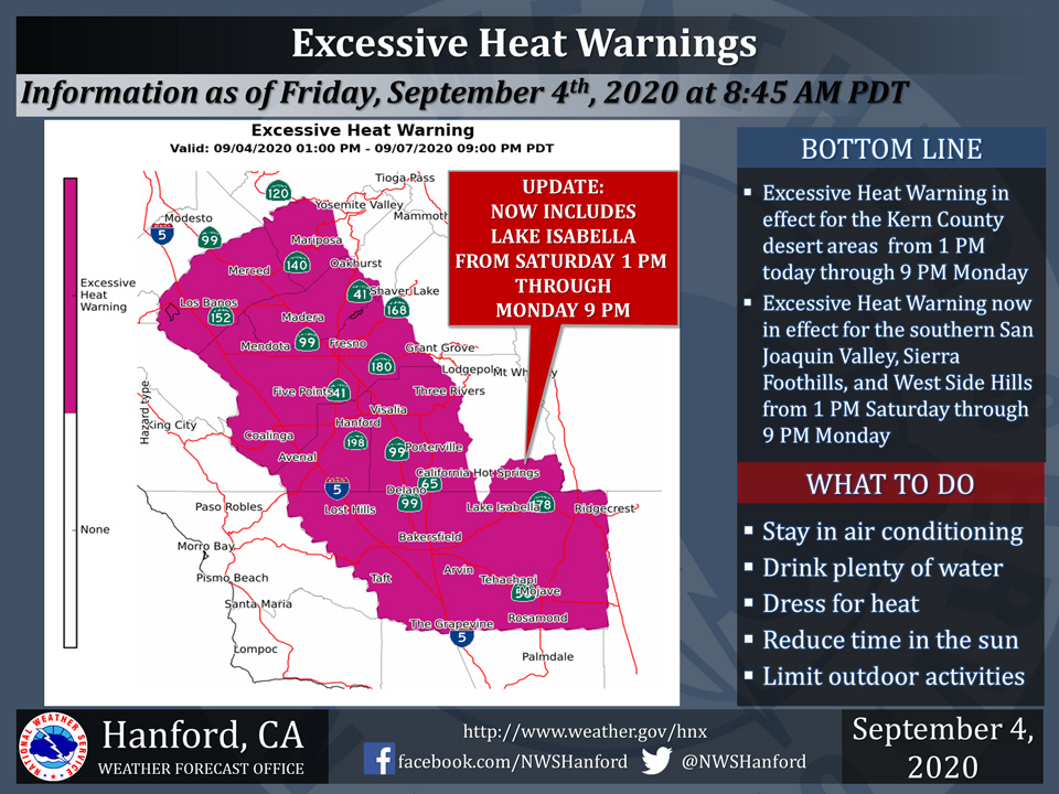
Excessive Heat Warning includes Mariposa and Oakhurst
September 4, 2020 - The National Weather Service Hanford Office reports an Excessive Heat Warning is in effect for the Kern County desert from 1 PM this afternoon until 9 PM Monday evening.
An Excessive Heat Warning is also in effect for the San Joaquin Valley, Sierra Nevada foothills, and West Side Hills from 1 PM Saturday afternoon until 9 PM Monday evening.
An Excessive Heat Warning means that a prolonged period of dangerously hot temperatures is expected.
Heat related illnesses, such as heat exhaustion and heat stroke are possible. Drink plenty of fluids, stay out of the sun, and remain in an air-conditioned room.
  Area Forecast Discussion
  National Weather Service Hanford CA
  358 AM PDT Fri Sep 4 2020


  .SYNOPSIS...Dangerous temperatures will impact the central
  California interior for the upcoming Labor Day Holiday. Some
  locations will be close or slightly above records, especially on
  Sunday and Labor Day. Temperatures will slowly decrease by
  Tuesday through next Thursday, but will remain above average.
  Smoke from surrounding wildfire will continue to plague the area
  for at least through Wednesday.

  &&

  .DISCUSSION...For today, high pressure will continue to slowly
  strengthen over the four-corners. Afternoon high temperatures will
  slightly increase for the West Side Hills and the Kern county
  desert. An Excessive Heat Warning will begin this afternoon for
  the Kern desert, where afternoon high temperatures will reach
  between 105 to 115 degrees with poor overnight recoveries.
  However, I have lower confidence for increasing temperatures in
  both the valley and foothills. This is because smoke from the SQF
  Complex wildfire will be more dense in these regions, which will
  counteract any synoptic warming. This will especially be the case
  from Tulare county northward to Merced county. As such, I have
  lowered the NBM temperatures a few degrees for these areas.

  From Saturday through Sunday, the aforementioned high pressure
  over the four-corners will strengthen to an impressive, and very
  anomalous 600 decameters. This high pressure will then start to
  slightly weaken on Labor Day as a deep trough begins to swing
  southward into the northern Great Basin. Temperatures through
  Labor Day will ramp up for all locations across the central
  California interior. An Excessive Heat Warning will take effect
  Saturday afternoon for the West Side Hills, Southern San Joaquin
  Valley, Southern Sierra Foothills, and portions of the Kern
  County mountains. The Excessive Heat Warning for all areas will
  remain in effect until Labor Day evening. Temperatures each day
  for these locations will range from 100 to 110 degrees. Low
  temperatures will range from 70 to 80 degrees, with urban areas
  and foothill locations seeing the poorest overnight recoveries.

  On Tuesday the prior mention trough will swing south through the
  Great Basin. Synoptic cooling across the region will slowly lower
  temperatures each day, but will remain above normal for mid-
  september.
Source: NWS

