


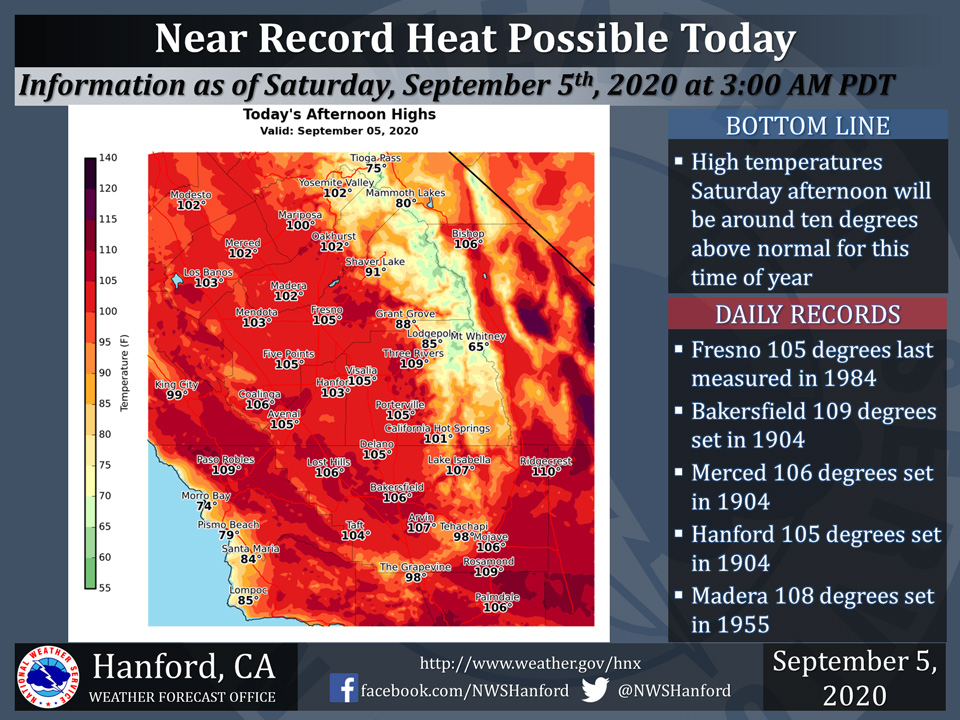
Saturday Projected High Temp for Mariposa: 100 Degrees
Saturday Projected High Temp for Oakhurst: 102 Degrees
Saturday Projected High Temp for Yosemite Valley: 102 Degrees
September 5, 2020 - The National Weather Service Hanford Office reports high temperatures throughout Central California Saturday afternoon should fall just short of tying or breaking daily records for maximum temperatures ever measured on September 5th.
An Excessive Heat Warning is in effect.
  Area Forecast Discussion
  National Weather Service Hanford CA
  251 AM PDT Sat Sep 5 2020

  .SYNOPSIS...
  Near record heat is expected in parts of Central California this
  afternoon. Record heat is likely in most of the forecast area
  Sunday and Labor Day. A downward trend in temperatures is expected
  Tuesday through Thursday. Be that as it may, temperatures will
  remain above seasonal values. Smoke from adjacent wildfires will
  continue to plague Central California through at least Wednesday.

  &&

  .DISCUSSION...
  An upper-level area of high pressure will remain centered over the
  Great Basin today and tonight. This anticyclone aloft will move
  westward Sunday and Sunday night. The upper-level area of high
  pressure will open up into a ridge of high pressure over
  California on Labor Day, before entering the Eastern Pacific Ocean
  Monday night. Near record heat is likely in Fresno and Hanford
  this afternoon. The daily records for maximum temperatures ever
  measured on September 5th is 105 degrees in both Fresno and
  Hanford. Record heat is likely in Fresno, Merced, Hanford, and
  Madera Sunday. The daily records for maximum temperatures ever
  measured on September 6th range from as "low" as 105 degrees in
  Hanford to as high as 108 degrees in Merced. Sunday could be the
  hottest day of the calender year in Bakersfield and Hanford.
  Record heat is likely in Fresno, Hanford, and Madera on Labor Day.
  The daily record for maximum temperatures ever measured on
  September 7th range from as "low" as 106 degrees in Hanford to as
  high as 108 degrees in Fresno and Madera. The brutal heat coupled
  with smoke impacts from wildfires in the Sequoia National Forest
  east of Porterville will make the outdoors unbearable this weekend
  into early next week. Stay indoors, if at all possible.

  A trough of low pressure will dive southward into the Desert
  Southwest Tuesday. This should cause winds to turn to the
  east-northeast and increase over the eastern portion of Kern
  County. These winds may advect a very dry airmass into the Kern
  County mountains, resulting in elevated or critical fire weather
  conditions for at least Tuesday afternoon into Tuesday night. An
  area of high pressure will be centered near the coast of Southern
  California Wednesday through Friday. Maximum temperatures Tuesday
  afternoon should be around five degrees lower than Monday
  afternoon. A downward trend in temperatures will continue
  Wednesday and Thursday. Regardless, high temperatures Thursday
  afternoon and Friday afternoon should be seven to nine degrees
  above normal for this time of year. Dry weather will persist
  through at least the next seven days.
Source: NWS

