


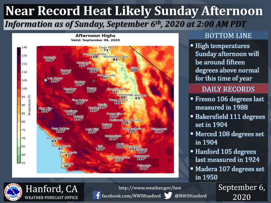
Sunday Projected High Temp for Mariposa: 107 Degrees
Sunday Projected High Temp for Oakhurst: 108 Degrees
Sunday Projected High Temp for Yosemite Valley: 108 Degrees
September 6, 2020 - The National Weather Service Hanford Office reports at or above record heat is almost certain to occur today at multiple locations across the San Joaquin Valley.
Extremely high temperatures over 110 degrees across the valley will lead to dangerous outdoor conditions, especially to those prone to heat-related illness.
  Area Forecast Discussion
  National Weather Service Hanford CA
  257 AM PDT Sun Sep 6 2020

  .SYNOPSIS...
  Record heat is likely in most of Central California today and
  Labor Day. A downward temperature trend is expected Tuesday
  through Saturday. Be that as it may, temperatures will remain
  above seasonal values. Smoke from adjacent wildfires will continue
  to plague Central California through at least Wednesday. Dry
  weather will persist for the foreseeable future.

  &&

  .DISCUSSION...
  An anticyclone aloft over the Great Basin will move westward today
  and tonight. The upper-level area of high pressure will open up
  into a ridge of high pressure over California on Labor Day, before
  progressing westward into the Eastern Pacific Ocean Monday night.
  Record heat is likely in Fresno, Merced, Hanford, and Madera
  today. Daily records for maximum temperatures ever measured on
  September 6th range from as "low" as 105 degrees in Hanford to as
  high as 108 degrees in Merced. Near record heat is probable in
  Bakersfield today. In addition, we are forecasting a high
  temperature of 112 degrees in Fresno this afternoon. This would
  break the record for maximum temperature ever measured in Fresno
  during the month of September. The current record of 111 degrees
  was initially established on September 11th, 1888, and last
  observed on September 3rd, 1955. Record heat is likely in Fresno,
  Hanford, and Madera on Labor Day. Daily records for maximum
  temperatures ever measured on September 7th range from as "low" as
  106 degrees in Hanford to as high as 108 degrees in Fresno and
  Madera. Near record heat is probable in Bakersfield and Merced on
  Labor Day. The brutal heat coupled with smoke impacts from
  wildfires in the Sierra Nevada will make the outdoors unbearable
  this weekend into early next week. Stay indoors, if at all
  possible. One more thing, a Wind Advisory may be required for a
  portion of the Kern County mountains and desert Monday afternoon
  and Monday night.

  A trough of low pressure will dive southward into the Desert
  Southwest Tuesday. This should cause winds to turn to the
  east-northeast and increase over the eastern portion of Kern
  County. These winds may advect a very dry airmass into the Kern
  County mountains, resulting in elevated or critical fire weather
  conditions for at least Tuesday afternoon into Tuesday night.
  Right now, the projected wind direction does not support a Mono
  wind event in the Sierra Nevada. An area of high pressure will be
  located just offshore of the Pacific Northwest Wednesday through
  Thursday night. This area of high pressure will move eastward
  Friday into the upcoming weekend. Maximum temperatures Tuesday
  afternoon will be around five degrees lower than Monday afternoon.
  Regardless, a Heat Advisory may be required for the San Joaquin
  Valley and West Side Hills Tuesday. A downward temperature trend
  should continue Wednesday through Saturday. Be that as it may,
  widespread triple digit heat is expected in the San Joaquin
  Valley and West Side Hills Wednesday afternoon. High temperatures
  Thursday afternoon and Friday afternoon should be seven to nine
  degrees above normal for this time of year. Maximum temperatures
  Saturday afternoon will be around five degrees above normal for
  this time of year. Dry weather will persist through at least the
  next seven days.
Source: NWS

