


California and National Drought Summary for September 8, 2020
Summary
September 10, 2020 - Conditions took a dramatic turn across the Rockies and Plains as the valid period ended, with hot and dry conditions suddenly replaced by much colder weather, and snow in some areas. A number of sites from the central Rockies into the northern Plains saw temperatures drop from around 90 degrees F Labor Day to near freezing with light snow the next morning. Denver, CO went from temperatures averaging 15 degrees above normal on September 6 to 30 degrees below normal for September 8, with an inch of snowfall reported. East Rapid City, SD appears to have set a national all-time record by going from over 100 degrees F (102) to reporting measurable snow in a span of 2 days. The colder and wetter weather that developed just as the period ended had little impact on drought conditions in most areas, given the hot, dry, and windy conditions that preceded it. Wildfires continued to scorch and spread rapidly across parts of California, with some quickly breaking out and expanding in part of the Rockies as well. Denver, CO went from reporting reduced visibility due to wildfire smoke on Labor Day, to reduced visibility from falling snow the next morning. Elsewhere, several inches of precipitation across interior northeastern Texas, in a swath from eastern Iowa to central Illinois, across Ohio, and in parts of Arkansas brought significant drought relief, and lesser amounts in adjacent areas brought more limited improvement, as did moderate precipitation in parts of the northern Rockies and adjacent Plains.
Northeast
The western fringe of Pennsylvania reported 1.5 to 3.5 inches of precipitation, as did a few patches across West Virginia, the lower Northeast, and southern New England. Most locations recorded several tenths of an inch of precipitation from central New England and central New York southward, with little or none falling farther north. Conditions generally persisted from last week, except in parts of Maine and adjacent locales, where D1 and D2 conditions expanded.
Southeast
Moderate to heavy rain – locally up to 5 inches -- soaked much of the Florida Peninsula, but little or none was recorded across the rest of the region. As a result, dryness was removed from the state of Florida, but scattered areas of abnormal dryness (D0) began popping up and expanding farther north from Alabama to South Carolina. Despite the dry week, however, the region remains drought free at this time.
South
Heavy rain soaked a large area across northeastern Texas, dramatically easing or ending drought and abnormal dryness. Some 2-category improvements were noted in the wettest areas. Heavy precipitation was less widespread in Arkansas and some adjacent areas, reducing the extent of abnormal dryness there. Across western Texas and farther east in Mississippi, dryness and drought expanded and intensified. Much of western Texas is now in extreme drought, with a small area of exceptional D4 drought in the interior Big Bend area. Parts of this region have received only a few tenths of an inch of precipitation since early August. Farther east, moderate drought was introduced in part of interior northeastern Mississippi where less than half of normal rainfall was recorded during the last 60 days.
Midwest
Generally 3 to 6 inches of precipitation fell from eastern Iowa to central Illinois, and in parts of central and northern Ohio, bringing significant relief to dry areas there. In contrast, little or none fell on most of Missouri, western Iowa, central and northern Minnesota, central and northern Wisconsin, most of the Upper Peninsula of Michigan, the southern half of Indiana, and most of southern Illinois, allowing for dryness and drought expansion in a few parts of these areas. Light to moderate precipitation elsewhere kept conditions generally unchanged from last week.
High Plains
The dramatic change to cold and wet (often snowy) conditions late in the period only brought notable improvement to southwestern North Dakota and part of interior southeast Colorado. Elsewhere, a few tenths of an inch of precipitation fell on the central Dakotas, scattered parts of Nebraska, and much of Wyoming, but given the hot and dry weather that prevailed until the end of the period, no areas experienced notable improvement. In fact, sizeable parts of northern North Dakota, the southern half of Wyoming, central and western Colorado, and Nebraska deteriorated. As a result, a large area of extreme drought (D3) now covers central and western Colorado and the central tier of Wyoming. Smaller areas of D3 are in north-central Wyoming and part of the Colorado Plains, with a small area of exceptional D4 drought persisting in the latter area. Conditions generally improve moving north and east of the D2 to D3 regions in the central Rockies and west-central Plains, though some severe to extreme drought expanded across central Nebraska while D2 to D3 persisted adjacent to Iowa.
West
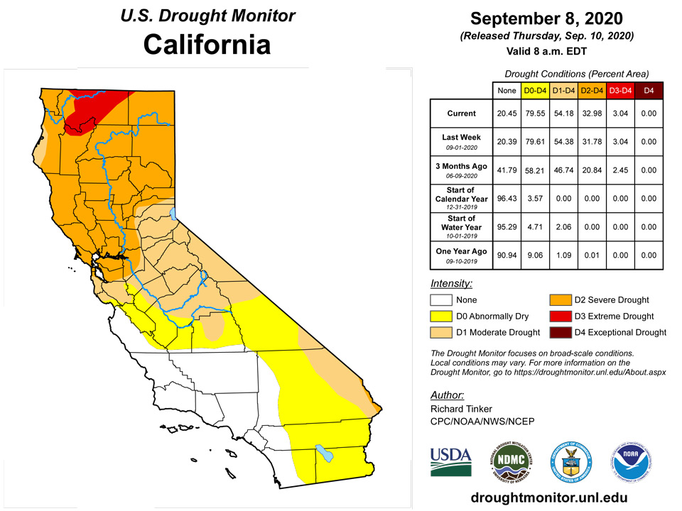
Another dry and, until the end of the period, hot week led to broad areas of drought intensification. The most widespread deteriorations were noted across Utah, Arizona, and to a lesser extent New Mexico. Exceptional D4 drought was introduced in central Utah, and a large area of extreme drought now envelops most of Utah, Arizona, northern and eastern New Mexico, and farther northwest through much of Oregon and adjacent California. Only parts of southwestern California, western Washington, central and southern Idaho, and adjacent areas remain free of abnormal dryness and drought. Fires continued to rage in portions of California, now having scorched over 2,000,000 acres in the state. Less than 30,000 acres were consumed by fire in 2019 through early September.
Alaska, Hawaii, and Puerto Rico
Increased precipitation helped the dry conditions in parts of Alaska. A few spots recorded a normal September’s worth of precipitation in the first week of this month. Still, given the prior dryness, improvements robust enough to depict on the Drought Monitor were limited to some D0 in central areas and in the Yukon Valley. Areas of moderate drought remained unchanged.
Subnormal rainfall continued affecting parts of southeastern Puerto Rico, prompting some northward expansion in the D0 area formerly limited to near the coast.
Unfavorably dry conditions continued across most of Hawaii, leading to the introduction of extreme drought (D3) on western parts of Molokai and southwestern Maui near the Maalaea Bay. Also, some D0 to D2 expansion occurred in central and northwestern parts of the state
Pacific Islands
A surface trough stretched across much of Micronesia, from Palau to the Marshall Islands (RMI), during the first half of this USDM week (9/2/20-9/8/20), and an active Inter-Tropical Convergence Zone (ITCZ) became established across the region as the week ended. Other features affecting the weather this week included more localized surface troughs and weak circulations and areas of trade-wind convergence, which migrated through the easterly trade-wind flow, and high pressure ridges interspersed between the migrating surface troughs. Tropical Storm Haishen intensified into a typhoon northwest of the Marianas early in the week and moved away, but not before feeder bands gave rain to parts of the Marianas. Upper-level lows and TUTT (Tropical Upper Tropospheric Trough) cells created divergence aloft, which complemented surface convergence, at northern latitudes from the Marianas eastward. South of the equator, a front and surface trough moved across the Samoan Islands as nearby high pressure weakened.
Satellite-based estimates of 7-day precipitation (QPE) showed a broken band of precipitation stretching eastward from Indonesia just north of the equator forming the climatological ITCZ, and another band extending southeast as the South Pacific Convergence Zone (SPCZ) to just north of the Samoan Islands and eastward. Patches of 1+ inches of rain extended southwest to northeast across Micronesia, with the heaviest areas (2+ inches) over eastern parts of the Federated States of Micronesia (FSM) and the RMI. The satellite QPE also depicted an area of heavy rain (4+ inches) along and west of the northern Marianas. Another area of 4+ inches was seen north and west of the Samoan Islands, with 2+ inch bands extending across American Samoa.
The Palau International Airport (IAP) measured 0.41-inch of rain this week, while the Koror COOP reported 1.07 inches. Eight of the last 12 weeks and 7 of the last 12 months have been wet (i.e. minimum rainfall values were met), and the 1-, 2-, and 3-month Standardized Precipitation Index (SPI) values are: +1.27, -0.18, and -0.42, respectively. Considering these rainfall and SPI data, the drought designation for the Republic of Palau remains unchanged, with no drought at this time.
In Guam, 1.38 inches of rain fell during the drought week, and this week marks the ninth consecutive wet week for this station. Drought-free conditions persist at Guam. At Dededo, 0.85-inch of rain fell (2 days missing). Rota measured 1.90 inches of rain this week, which marks its seventh consecutive wet week. Rota's drought designation was improved from D0(SL) to no drought this week. Tinian measured 2.25 inches of rain this drought week (2 days missing). At the northern end of the Commonwealth of the Mariana Islands, a manual gauge at the Saipan International Airport recorded 1.10 inches for the week, the National Park Service recorded 0.70-inch, and a Saipan ASOS station reported 0.43-inch of rain. Saipan's classification continues at D0(SL) this week.
In the western part of Micronesia, Yap reported 0.48-inch of rain this week. North Fanif and Rumung measured 0.94-inch (2 days missing) and 0.45-inch (4 days missing) of rain, respectively. Ulithi saw 0.84-inch during the week. Woleai measured 2.47 inches, which comfortably surpassed the weekly minimum threshold of 2 inches considered adequate to meet most water needs. Across central Micronesia, 0.78-inch of rain fell at Fananu (1 day missing), and Nukuoro (which has been dry recently) measured 0.84-inch of precipitation this week. Chuuk Lagoon and Lukunoch received 2.88 and 2.14 inches (1 day missing) of rain, respectively, with both totals exceeding the 2-inch minimum. The drought situation on Kapingamarangi remains especially problematic, with only 0.42-inch of precipitation reported this week. Unlike the surrounding outer islands, Kapingamarangi has missed out on recent rainfall. For 12 straight days (mid-August to 28 August), no rain fell at this location. Observers on Kapingamarangi report household water tanks are near 10% of capacity, and some are empty. Kapingamarangi has seven community tanks (six plastic and one concrete) that are reserved for emergency situations, and three of these community tanks are now in use. Vegetation has started yellowing. Following are a few of Kapingamarangi's precipitation rankings: 1) this August was their 3rd driest on record, 2) the May through August period was the driest on record, and 3) the island experienced its second driest April through August period. Last week, the island's drought designation was downgraded from D1(S) to D2(S), and D2(S) remains for this week. In eastern Micronesia, rainfall totals for the week included Pohnpei (3.02 inches), Kosrae (5.46 inches), and Pingelap (0.74-inch). With the exception of Kapingamarangi, all locations within the Federated States of Micronesia (FSM) remain drought-free.
In the Republic of the Marshall Islands (RMI), Kwajalein received a bountiful 5.50 inches of rain this week, which is 2.75 times the minimum amount considered necessary to meet most water needs. SPI values for Kwajalein at the 1-, 2-, 3-, and 6-month periods are (respectively): -1.52, -1.33, -1.42, and -0.92. Despite these dry SPI values in recent months, the 5.50 inches of rain that fell this week at Kwajalein was more than enough to justify a one-category improvement and resulting drought-free conditions. Generous rains fell across the remainder of the RMI this week. Ailinglapalap recorded 2.31 inches, Majuro 2.32 inches, Jaluit 1.38 inches (1 day missing), and Mili 0.44-inch. Variable precipitation amounts were noted in Jaluit during the past 5 weeks, and this area is being monitored for possible degradation. As of August 31st, the reservoir in Majuro stood at 86% of its maximum storage capacity. In Wotje, 1.95 inches of rain was measured this week. Although this total is very close to the weekly rainfall minimum threshold, a one-category improvement being considered was postponed because of drought-related impacts being reported across the island. These impacts include water catchments at public school systems which are now half-full and dropping, and the yellowing of vegetation. The decision to postpone improvement was also made despite a very wet August, when 12.71 inches of rain fell (just above the 97th percentile). Rainfall data continue to be missing from Utirik.
The combination of a surface trough and a front resulted in a very wet week for American Samoa. Pago Pago received 9.05 inches of rain this week, which trounced the weekly minimum threshold of 1 inch. In fact, this total is slightly more than 2.25 times the monthly threshold of 4 inches! Siufaga Ridge (a National Park Service site) reported a comparable amount of precipitation at 8.77 inches. Toa Ridge (another National Park Service site) was not too far behind at 6.54 inches. Drought-free conditions continue on the island of Tutuila.
Virgin Islands
One-hundredth of an inch of rain was reported yesterday at the Cyril E. King airport on St. Thomas. The Month-To-Date (MTD) rainfall total is 0.49-inch. The Year-To-Date (YTD) total stands at 17.04 inches of rain, which is 4.53 inches below normal for the period (normal is 21.57 inches). Anna's Retreat (CoCoRaHS station VI-ST-1) reported 0.30-inch for the drought week (Sept 2-8), and 1.34 inches for the month of August 2020. SPI values for Charlotte Amalie at the 1-, 3-, 6-, 9-, and 12-month periods are: -1.03, -0.31, -0.82, -0.24, and -0.99, respectively. Based on rainfall and SPI data, the drought designation for St. Thomas continues at D0(L).
On the island of St. John, Windswept Beach (CoCoRaHS VI-SJ-3) measured 0.58-inch of rain this drought week, which is a bit below average. If the 0.10-inch of rain that fell on September 1st is included, the MTD total is 0.68-inch. For the month of August, Windswept Beach received 4.11 inches of rain. SPI values for Windswept Beach at the 1-, 3-, 6-, 9-, and 12-month periods are: +0.10, -0.24, -1.08, -0.49, and -0.79, respectively. Based on rainfall and SPI data, the drought designation for St. John was maintained at D0(L).
The Henry E. Rohlsen airport on St. Croix received 0.08-inch of precipitation yesterday, and the MTD total is 0.53-inch. The YTD total stands at 17.98 inches of rain, which is 3.46 inches below normal for the period (normal is 21.44 inches). At this time last year, 16.51 inches of rain had fallen, about 1.5 inches behind this year's YTD so far. CoCoRaHS stations VI-SC-8 (Christiansted 1.8 ESE) and VI-SC-9 (Christiansted 4.1 ESE) reported 0.44-inch and 0.00-inch of rain this week, respectively. For the month of August, the rainfall totals were (respectively) 3.63 inches and 3.71 inches. SPI values for Christiansted at the 1-, 3-, 6-, 9-, and 12-month periods are: +0.76, +0.38, -0.20, -0.33, and -1.77, respectively. Based on rainfall and SPI data, the drought designation for St. Croix continues at D0(L).
Looking Ahead
During the next 5 days (September 10-14), WPC’s QPF forecasts little or no precipitation (and thus persisting or intensifying drought) across the northern Plains and most areas from the Rockies to the Pacific Coast, save higher elevations in New Mexico and southern Colorado (0.5 to 1.5 inch). Similarly, light precipitation at best is expected across southern half of the Mississippi Valley and the western Ohio Valley. The heaviest precipitation (2 to 4 inches) is expected in a broad swath from southwestern Oklahoma through much of the Rio Grande Valley. Farther north, between 1.5 and 2.5 inches are expected from northern Missouri northeastward into western Wisconsin – part of a broader area expecting over 0.5 inch through much of central and western Texas, the central Great Plains, the Upper Mississippi Valley, and most of the Great Lakes region. Moderate precipitation, from 0.5 to 1.5 inches, should cover most of New England, New York, and the dry portions of Pennsylvania. Similar amounts are expected in the Southeast from Alabama eastward, with heavier amounts (1.0 to locally 2.5 inches) forecast in the Carolinas. From the central Gulf Coast through most of the eastern U.S., near-normal daytime temperatures should average a few degrees above normal at night. Temperatures should average a few degrees below normal from the southeastern Rockies through most of the central and southern Plains and the Great Lakes region, but near- to somewhat above-normal across most of the northwestern quarter of the country.
The Climate Prediction Center’s 6-10 day outlook (September 15-19) favors above-normal rainfall from the Ohio Valley, Middle Mississippi Valley, and central Texas eastward to the Atlantic Coast. Wet weather is also expected in the Northwest while odds again favor subnormal precipitation in much of the Great Basin, Four Corners States, and northern half of the Plains. In addition, surplus moisture is expected along the southern tier of Alaska, but subnormal precipitation is anticipated in the northern reaches of the state. Portions of central and southwestern Texas, plus eastern Alaska, should record below-normal temperatures while the near- to above-normal readings prevail elsewhere.
Author(s):
Richard Tinker, NOAA/NWS/NCEP/CPC
Anthony Artusa, NOAA/NWS/NCEP/CPC
Dryness Categories
D0 Abnormally Dry—used for areas showing dryness but not yet in drought, or for areas recovering from drought.
Drought Intensity Categories
D1 Moderate Drought
D2 Severe Drought
D3 Extreme Drought
D4 Exceptional Drought
Drought or Dryness Types
S Short-Term, typically less than 6 months (e.g. agricultural, grasslands)
L Long-Term, typically greater than 6 months (e.g. hydrologic, ecologic)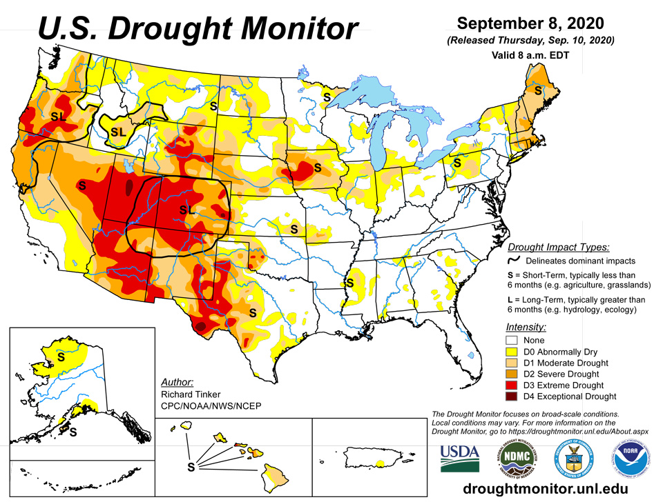
Source: National Drought Mitigation Center

