


California and National Drought Summary for September 15, 2020
Summary
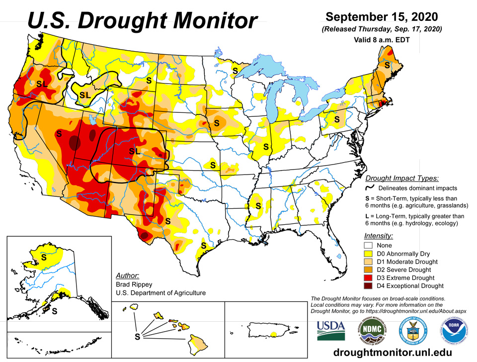
September 17, 2020 - Dozens of dangerous and sometimes deadly wildfires continued to burn across the West, with the greatest concentration of blazes affecting the parched Pacific Coast States. By mid-September, 16 active fires in California, Oregon, and Washington had scorched at least 100,000 acres of vegetation, along with two in Colorado. At least a dozen active wildfires had destroyed more than 100 structures, while some three dozen fatalities have been reported, with several individuals still unaccounted for. Farther east, periods of heavy rain (and high-elevation snow) occurred across portions of the Rockies, Plains, and Midwest, boosting topsoil moisture and benefiting drought-stressed rangeland and pastures. However, excessive rain fell in some areas, including parts of Texas, sparking local flooding. In conjunction with the heavy precipitation, a sharp, early-season cold snap delivered record-setting low temperatures across the Plains, Rockies, and upper Midwest, while summer-like heat lingered along and near the Pacific Coast. Meanwhile, heavy showers associated with Tropical Storm Sally—later a hurricane—spread across Florida’s peninsula during the weekend of September 12-13. Excessive rain fell in southern portions of the state, including the Florida Keys. Later, as a Category 2 hurricane, Sally made landfall on September 16 near Gulf Shores, Alabama, around 4:45 am CDT, with sustained winds near 105 mph. Sally dumped historic and catastrophic amounts of rain in southern Alabama and western Florida. In addition, high winds caused extensive damage and power outages along and near the Gulf Coast, while a significant coastal storm surge occurred along and to the east of the landfall location. Once inland, Sally exhibited rapid weakening but continued to spark heavy rainfall and flash flooding.
Northeast
The meteorological summer (June-August) of 2020 was one of the hottest and driest on record in parts of the Northeast. For example, it was the hottest summer on record in Williamsport, Pennsylvania, where the June-August average temperature of 74.4°F tied a mark originally set in 1904 and achieved again in 2016. It was the warmest summer in Caribou, Maine, with an average temperature of 66.9°F (previously, 66.3°F in 2018). Caribou also endured its second-driest summer, with just 6.16 inches of rain (54% of normal). The driest summer in Caribou was 1995, with 5.60 inches of rain. Given the protracted period of heat and dryness, drought continues to expand and intensify in many areas. Two areas of extreme drought (D3) were introduced—one in northern Maine and the other in southern New England. Moderate to severe drought (D1 to D2) was broadly expanded in several areas. On September 13, topsoil moisture as reported by the U.S. Department of Agriculture was rated 99% very short to short in Maine, along with 94% in New Hampshire and 92% in Rhode Island. Pastures rated in very poor to poor condition ranged from 90 to 100% in Connecticut, Massachusetts, and Rhode Island.
Southeast
Only spotty dryness (D0) exists in the Southeast. With Hurricane Sally moving ashore on September 16 across southern Alabama and drifting northeastward, there is currently much more focus on flooding than dryness. Still, areas west of Sally’s path have dried out in recent days and will need to be monitored for possible introduction or expansion of dryness. In Huntsville, Alabama, rainfall during the first half of September totaled just 0.06 inch (3% of normal).
South
During the drought-monitoring period, drenching rainfall struck parts of Texas. Abilene, Texas, measured a daily-record sum of 3.80 inches on September 9. Abilene’s 3-day (September 9-11) rainfall reached 4.89 inches, with more than 10 inches reported in a few nearby locations. Aggressive improvements were introduced in the hardest-hit areas, which extended northward into Oklahoma. During the week ending September 13, topsoil moisture in Texas improved from 64 to 44% very short to short. Oklahoma’s topsoil moisture rated very short to short improved from 49 to 29%. Farther east, however, patchy dryness (D0) and moderate drought (D1) existed, particularly in Mississippi, where topsoil moisture rated very short to short stood at 48% on September 13. During the first half of September, rainfall in Mississippi totaled 0.22 inch (13% of normal) in Meridian and 0.03 inch (2%) in Vicksburg.
Midwest
Dramatic drought improvement came to many areas in the form of a multi-day rain event. Measurable rain fell each day from September 6-12 in Iowa locations such as Dubuque and Davenport, totaling 7.46 and 7.76 inches, respectively. During the same 7-day period, Moline, IL, received 5.97 inches. Broad improvements were introduced where the heaviest rain fell, but some eastern sections of the Midwest remained dry and saw some development or expansion of abnormal dryness (D0). Extreme drought (D3) was erased from Iowa, with only patch of D3 remaining in eastern Nebraska. In contrast, September 1-15 rainfall totaled just 0.04 inch (3% of normal) in Indianapolis, Indiana, and 0.50 inch (32%) in Saint Louis, Missouri.
High Plains
Mixed signals were apparent in drought-affected sections of the High Plains, as drought impacts were only slightly ameliorated by recent rain and snow. Still, topsoil moisture improved dramatically in Nebraska, from 73 to 45% very short to short, during the week ending September 13. Even with the precipitation, topsoil moisture on September 13 was rated 72% very short to short in Colorado. In addition, Colorado led the nation—among major production states—in very poor to poor ratings for sorghum (39%) and corn (33%). Wyoming led the region with rangeland and pastures rated 78% very poor to poor.
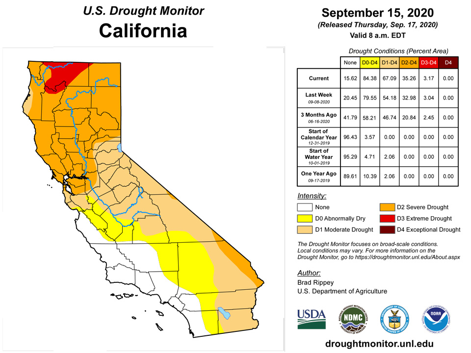
West
Dry weather dominated the Far West, including California, the Great Basin, the northern Rockies, and the Pacific Northwest, leading to extensive drought intensification as wildfires continued to burn hundreds of thousands of acres and degrade air quality. However, temperatures fell from record-setting levels that had been achieved earlier in the month. During the heat wave, which peaked amid the previous drought-monitoring period, September 6 was the hottest day ever recorded in California locations such as Woodland Hills (121°F), Paso Robles (117°F), and San Luis Obispo (117°F). Many other communities from California to the Southwest reported record-high September temperatures. The list of September records set or tied on the 6th included 120°F in Needles, California; 117°F in Riverside, California; 112°F in Gilroy and Lancaster, California; 110°F in Kingman, Arizona, and Stockton, California; 109°F in Sacramento, California; 105°F in Hanksville, Utah; 99°F in Cedar City, Utah; and 91°F in Rock Springs, Wyoming. Intense heat persisted through September 7 in the San Francisco Bay area, where Gilroy again reached 112°F. Richmond, California, noted its highest-ever temperature (107°F) on the 7th, tying September 15, 1971. By September 13, USDA topsoil moisture was rated at least 60% very short to short in every Western State except Arizona. Rangeland and pastures rated very poor to poor ranged from 35% in Nevada and Utah to 82% in Oregon. A new patch of exceptional drought (D4) was introduced along the Nevada-Utah border. Extreme drought (D3) was expanded in several areas, including western Oregon. However, the eastern edge of the West, mainly from Wyoming to New Mexico, received some much-needed precipitation. In some cases, however, the rain and snow merely staved off further drought intensification. Still, September 7-8 snowfall in Wyoming totaled 7.5 inches in Casper and 4.7 inches in Lander. Alamosa, Colorado, received an incredible 13.6 inches of snow from September 8-10, breaking a monthly record originally set when 10.0 inches fell on September 27-28, 1936.
Alaska, Hawaii, and Puerto Rico
Roughly the southern half of Alaska’s Seward Peninsula received significant precipitation, resulting in some trimming of abnormal dryness (D0). Otherwise, the depiction of dryness and drought across northwestern and south-central Alaska remained unchanged. Meanwhile, two areas of severe drought (D2) were introduced in Hawaii—one on the southern part of Maui and the other in the in Kohala District on the Big Island—due to declining pasture conditions. There were no changes in Puerto Rico, where a spot of dryness (D0) persists across the southern part of the island.
Pacific Islands
The weather across the U.S.-Affiliated Pacific Islands (USAPI) during this USDM week (9/9/20-9/15/20) mostly consisted of surface (trade-wind) troughs migrating across Micronesia. Precipitation resulting from convergence with the surface troughs was enhanced by divergence aloft associated with upper-level lows and troughs, especially over Palau, western Yap State, and the Marianas. A few weak disturbances or circulations made brief appearances, and an Inter-Tropical Convergence Zone (ITCZ) tried to set up at times across the region, but the ITCZ was limited in area and duration. South of the equator, a stationary front lingered just south of the Samoan Islands, with showers occasionally moving over American Samoa, but a dry and stable airmass dominated for much of the week.
Satellite-based estimates of 7-day precipitation (QPE) showed two bands of precipitation extending eastward from Indonesia. One stretched southeast toward then south of the Samoan Islands as the climatological South Pacific Convergence Zone (SPCZ). The other extended across Micronesia then past the Date Line as the climatological ITCZ. The QPE depicted patchy areas of 1+ inches of rain over Palau, Yap State, and the Marianas, with embedded areas of 2+ inches and surrounded by areas having less than half an inch of rain. A narrow band of 1+ inch rainfall extended across Chuuk and Pohnpei States between roughly 5 and 10 degrees north latitude, and a wider band of 1 to 4 inches stretched from about 2 N to 10 N over Kosrae State and the Marshall Islands (RMI) before narrowing again. The QPE showed a broad area of 1 to 4 inches of precipitation south and west of the Samoan Islands, with lesser amounts extending across American Samoa.
Rainfall this week in American Samoa was much lower than last week’s heavy amounts, but still reached weekly minima everywhere. Pago Pago received 1.65 inches, Suifaga Ridge received 2.56 inches, and Toa Ridge received 1.75 inches. Conditions remained free of drought for another week.
After missing their weekly minimum of 2 inches the last couple weeks, Koror received 2.43 inches of rain this week, and 2.17 inches fell at Palau International Airport, allowing drought-free conditions to continue another week.
Short- and long-term abnormal dryness continued this week on Saipan. Rainfall there varied widely, from 0.80 to 3.24 inches, but even with higher totals in some areas, long-term rainfall deficits persist. On Rota, 1.61 inches of rain followed 1.90 inches last week, continuing a streak of sufficient rainfall, and drought-free conditions continued. On Guam, after hefty rainfall in August (particularly the last week), drought-free conditions continued as rainfall amounts continued to exceed an inch (1.38 and 1.42 in the last two weeks, respectively).
After a drier last couple of weeks, at least 5 inches of rain fell this week on Yap, and drought-free conditions continued. Similar weather occurred on Ulithi, where 4.67 inches of rain this week followed a drier previous week (0.84 inches), and drought-free conditions continued. After a dry last week of August, 2.47 and 3.69 inches of rain have fallen last week and this week on Woleai, continuing drought-free conditions there. Rainfall this week on Fananu reached at least 3.31 inches, and drought-free conditions continued. At Chuuk, 1.57 inches of rain was reported this week, but with wetter preceding weeks, drought-free conditions continued there. Recent rainfall on Lukunor has been variable, as several weeks over the past month have featured little rainfall, while others recorded rain from more than 3 inches to almost 7 inches. While this week only saw 1.10 inches of rain there, sufficient rainfall for the last six months means that drought-free conditions are continuing. Short-term severe drought continued on Kapingamarangi, where this week’s rainfall only added up to 0.21 inches, marking the eleventh consecutive week with less than 2 inches of rainfall there. Per local reports, vegetation there is continuing to yellow as a result of the short-term severe drought. On Pohnpei, 4.04 inches of rain fell this week, and drought-free conditions continued. On Pingelap, the last couple weeks have been dry, with 0.74 and 1.40 inches of rain last week and this week, respectively. However, wet conditions before this mean that the area remained drought-free. Wet weather continued on Kosrae the last couple weeks, with 5.46 inches of rain last week and 4.95 inches this week, resulting in the continuation of drought-free conditions.
Only 1.17 inches of rain fell on Kwajalein this week, though given the 5.5 inches that fell last week, drought-free conditions continue. On Ailinglapalap, after a string of mostly dry weeks from the middle of July through August, the last couple weeks have seen sufficient rainfall, with 2.31 and 4.19 inches, respectively. Thus, short-term abnormal dryness gave way to normal conditions. Short-term abnormal dryness developed on Jaluit, where the last four weeks have fallen below 2 inches of rainfall; rainfall this week totaled 1.05 inches. No depiction of conditions was made for Utirik, as the data there are missing. Short- and long-term severe drought continued on Wotje, though given 2 inches of rain this week (all of this fell in one day), conditions may be starting to improve there. On Majuro, 3.70 inches of rain this week continued a run of four consecutive weeks with at least 2 inches of rain, and drought-free conditions continued. After a couple dry weeks, 3.20 inches of rain fell on Mili, so the area remains drought free.
Virgin Islands
Long-term abnormal dryness continued on St. Thomas, St. John, and St. Croix this week, due to long-term precipitation deficits. Heavier rains occurred over the past week on each island, though primarily on their western ends.
Looking Ahead
Former Hurricane Sally will drift northeastward, crossing the Carolinas on Friday. Storm-total rainfall in southern Alabama and western Florida could reach 10 to 20 inches, with isolated amounts near 35 inches. Well inland, rainfall could total 4 to 10 inches from east-central Alabama into portions of the Carolinas and southeastern Virginia. Meanwhile, Sally’s storm-surge and wind-related impacts will continue to subside. Most of the remainder of the country will experience dry weather during the next 5 days, although a series of cold fronts will deliver some precipitation from the Pacific Northwest to northern sections of the Rockies and High Plains. Parts of southern Texas will also receive rain. Elsewhere, a surge of cool air will affect much of the South, East, and Midwest, while generally warm weather will cover the West. However, by week’s end and early next week, warmth will replace previously cool conditions across the northern Plains and upper Midwest.
The NWS 6- to 10-day outlook for September 22 – 26 calls for the likelihood of cooler-than-normal conditions in most areas along and east of a line from central Texas to Lake Ontario, while above-normal temperatures will dominate the Plains, West, and upper Midwest. Meanwhile, wetter-than-normal weather in the Four Corners region, Deep South Texas, and the Pacific Northwest should contrast with near- or below-normal precipitation across the remainder of the country.
Author(s):
Brad Rippey, U.S. Department of Agriculture
Curtis Riganti, National Drought Mitigation Center
Dryness Categories
D0 Abnormally Dry—used for areas showing dryness but not yet in drought, or for areas recovering from drought.
Drought Intensity Categories
D1 Moderate Drought
D2 Severe Drought
D3 Extreme Drought
D4 Exceptional Drought
Drought or Dryness Types
S Short-Term, typically less than 6 months (e.g. agricultural, grasslands)
L Long-Term, typically greater than 6 months (e.g. hydrologic, ecologic)
Source: National Drought Mitigation Center

