


California and National Drought Summary for September 29, 2020
Summary
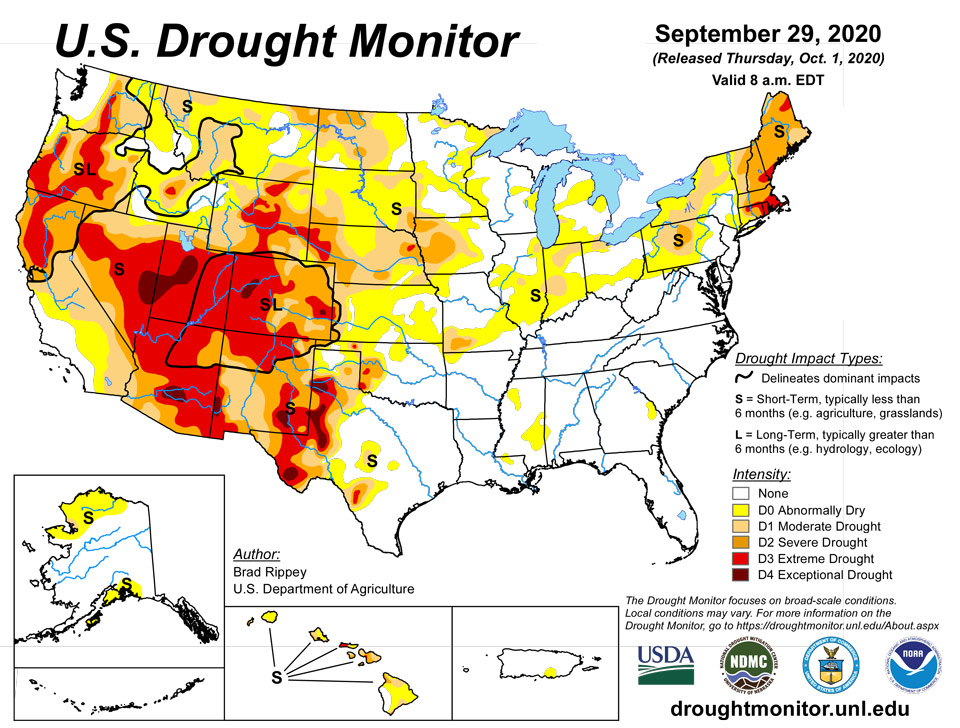
October 1, 2020 - Tropical Storm Beta made landfall on September 21 about 10 pm CDT near Port O’Connor, TX, with sustained winds near 45 mph. Once inland, slow-moving Beta weakened and turned northeastward, crossing the Mississippi Delta before dissipating on September 25 over the Southeast. Nevertheless, heavy rainfall associated with Beta caused local flooding, especially along and near the middle and upper Texas coast. Beta’s heavy rain tracked across an area (centered on Mississippi) experiencing abnormal dryness (D0) and moderate drought (D1), leading to a significant boost in soil moisture. Mostly dry weather covered the remainder of the country, aside from a few showers in the upper Great Lakes region and some beneficial precipitation in the Northwest. Across much of the Plains and Midwest, open weather favored agricultural fieldwork but further reduced topsoil moisture in drought-affected areas. In fact, worsening drought remained a major concern across much of the western half of the country, with adverse impacts on rangeland and pastures. In addition, the return of hot, windy weather fanned several new Western wildfires. Near- or above-normal temperatures prevailed in the West, with the hottest weather occurring in the Four Corners States. As the drought-monitoring period ended on September 29, approaching heavy rain brought the promise of relief to the Northeast, enduring its second major drought in 5 years.
Northeast
During the drought-monitoring period, which ended on the morning of September 29, mostly dry weather prevailed in the Northeast. Rain falling after the cutoff time will be assessed for next week’s report. Through daybreak on September 29, drought impacts continued to mount, with many more locations reporting wells running dry. Streamflow remained exceedingly low, while agricultural impacts remained severe. As mentioned last week, mid-September freezes that ended the growing season, combined with drought, may inhibit pasture recovery until the spring of 2021. On September 27, the U.S. Department of Agriculture rated 100% of Rhode Islands pastures in very poor to poor condition, along with 92% in Connecticut and Massachusetts. On the same date, USDA topsoil moisture was rated 100% very short to short in Maine and New Hampshire. Worsening conditions led to further expansion of moderate to extreme drought (D1 to D3) from Pennsylvania to New England, as well as a southward expansion of abnormal dryness (D0). Through the 28th, Northeastern month-to-date rainfall totals that would set September records (if no rain fell on the last 2 days of the month) included Burlington, Vermont (0.25 inch); Portland, Maine (0.24 inch); Augusta, Maine (0.18 inch); Saint Johnsbury, Vermont (0.17 inch); Caribou, Maine (0.14 inch); and Bangor, Maine (0.07 inch). Those September 1-28 totals were 2 to 7% of normal rainfall values.
Southeast
The remnants of Tropical Storm Beta dumped heavy rain near the Alabama-Georgia-Tennessee triple point, eliminating abnormal dryness. Chattanooga, Tennessee, reported a daily-record rainfall sum of 3.91 inches on September 24. Only a few spots of abnormal dryness (D0) remained in the Southeast—two small areas in coastal Georgia and South Carolina, as well as a touch of dryness in western Alabama.
South
The remnant circulation of Tropical Storm Beta tracked across the area of abnormal dryness (D0) and moderate drought (D1) centered on Mississippi. September 21-24 rainfall topped 4 inches in locations such as Natchez, Mississippi (5.35 inches); Monroe, Louisiana (4.83 inches); and Texarkana, Arkansas (4.13 inches). Following Beta’s passage, D1 was eliminated from Mississippi. However, southeast of Beta’s area of influence, parts of eastern Mississippi saw mounting short-term precipitation deficits and a corresponding increase in D0 coverage. Farther west, parts of central Texas continued to benefit from recent heavy rainfall, while conditions rapidly worsened across the High Plains of Texas and Oklahoma. In fact, two new areas of exceptional drought (D4) were introduced in western Texas. Through September 29, year-to-date precipitation in Midland, Texas, totaled just 6.84 inches (59% of normal). In Texas’ northern panhandle, year-to-date precipitation had not yet reached the 9-inch mark in Borger and Dalhart. Borger’s 8.87-inch total was 48% of normal. On September 27, Texas led the country—among major production states—in cotton rated very poor to poor (35%). Oklahoma led the nation with 47% of its sorghum rated very poor to poor, according to USDA.
Midwest
Despite scattered showers, mainly in the Great Lakes region, some areas continued to experience an expansion of short-term dryness (D0) and moderate drought (D1). September 1-29 rainfall totaled just 0.12 inch (4% of normal) in Indianapolis, Indiana, and 0.90 inch (30%) in Saint Louis, Missouri. However, many farmers welcomed the open weather during harvest season. For example, the nation’s soybean harvest was 20% complete by September 27, compared to the 5-year average of 15%.
High Plains
Dry, occasionally breezy weather led to a “flash-drought” situation, with rapid development or expansion of dryness and drought. Several days of summer-like warmth contributed to the drying; in Nebraska, daily-record highs rose to 95°F in Valentine (on September 22) and North Platte (on September 23). On September 24, East Rapid City, South Dakota, noted a daily-record high of 93°F. By September 27, topsoil moisture across the region rated very short to short ranged from 49% in Kansas to 77% in Colorado. Wyoming led the region with rangeland and pastures rated 64% very poor to poor. Colorado producers had planted 66% of their intended winter wheat acreage by September 27, leading the nation (and 9 percentage points ahead of the 5-year average), but only 19% of the crop had emerged (8 points behind average). These statistics—rapid planting but slow emergence—were indicative of dry conditions.
West
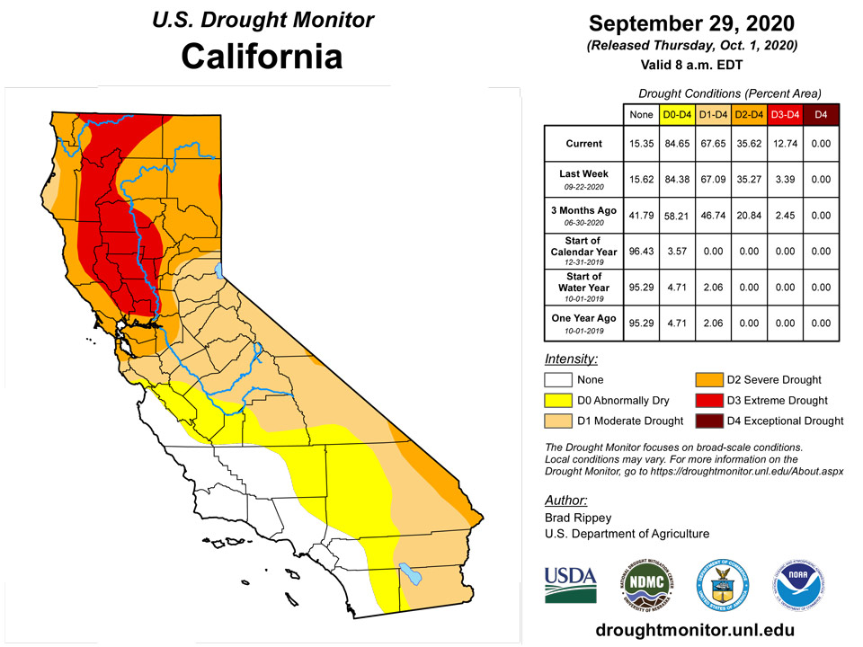
Precipitation in the Pacific Northwest aided wildfire containment efforts and brought slight improvement in the drought situation, mainly west of the northern Cascades. However, the remainder of the West remained warm and dry, with gusty winds and low humidity levels contributing to another round of dangerous wildfire activity in northern California. The much-needed Northwestern precipitation delivered daily-record amounts on September 23 in western Washington locations such as Hoquiam (1.32 inches); Olympia (1.23 inches); and Seattle (1.08 inches). Troutdale, Oregon, reported more than an inch of rain on September 18, 23, and 25—with totals of 1.13, 1.18, and 1.02 inches, respectively. Precipitation spread as far inland as the northern Rockies; in Idaho, daily-record totals included 0.55 inch (on September 25) in Stanley and 0.54 inch (on September 26) in McCall. Farther south, several new patches of exceptional drought (D4) were introduced or expanded in Colorado, New Mexico, Arizona, and Utah. As the water year (October 1, 2019 – September 30, 2020) came to an end, extreme drought (D3) was expanded in northern California and portions of neighboring states. California’s two most dangerous new wildfires were the Glass and Zogg Fires, both of which started on September 27. The Glass Fire, in Napa and Sonoma Counties, and the Zogg Fire, in Shasta County, both scorched about 50,000 acres of vegetation a couple of days, with little containment. Meanwhile, very poor to poor ratings were indicated by USDA on September 27 on at least 50% of rangeland and pastures in all Western States except Idaho, Nevada, and Utah, led by Oregon (82% very poor to poor). On the same date, topsoil moisture was at least 60% very short to short in every Western State except Arizona, led by New Mexico (86% very short to short).
Alaska, Hawaii, and Puerto Rico
A wet September in the upper Koyukuk and Kobuk River basins in northwestern Alaska led to some further reduction in the coverage of abnormal dryness (D0) in Alaska. Farther south, heavy precipitation hit Kodiak Island, where moderate drought (D1) was eliminated after 8.58 inches fell from September 21-29. Neighboring areas in south-central Alaska saw a reduced coverage of D0. Meanwhile, weather in Hawaii was generally warm and mostly dry. However, locally heavy rain fell across windward sections of the Big Island, where Hilo netted a daily-record rainfall of 4.78 inches on September 23. Reports from other eastern locations on the Big Island indicated as much as 6 to 10 inches of rain fell in a 24-hour period on September 23-24, resulting in dryness (D0) replacing moderate drought (D1). Leeward sections of the Big Island remained dry, however, maintaining poor vegetation health and necessitating an expansion of moderate to severe drought (D1 to D2). Elsewhere, there were no changes in Puerto Rico, where a spot of abnormal dryness (D0) persisted at various time scales along the southern coast.
Pacific Islands
Rainfall totals were less than 2 inches at Palau’s International Airport and the COOP station for the week ending September 29. The monthly rainfall total was 6.43 inches at the airport and over 10 inches at the COOP station. Although rainfall totals for the week were slightly below the 2-inches threshold to meet most water needs, drought free conditions continued across Palau.
Across the Marianas, Guam and Rota had a wet week, with precipitation totals over the weekly 1-inch threshold to meet most water needs. Rota had the most rainfall at 5.39 inches for the week and a monthly total of 17.90 inches. Guam’s monthly rainfall total was over 10 inches. Both of these locations continued in drought free conditions. Saipan was the exception, experiencing a dry week. Rainfall totals were 0.06 inch at the manual gauge, 0.60 inch at the ASOS station, and 0.20 inch at the NPS station. However, last week was a very wet week for Saipan, receiving almost 5 inches of rain. The monthly rainfall total for Saipan was 7.46 inches. Drought free conditions were unchanged for Saipan.
Several FSM locations (Lukunor, Kapingamarangi, and Ulithi) had a dry week, receiving less than 1 inch of rain. Of these stations, Kapingamarangi had the least amount of rain at 0.23 inch of rain for the week. Following a dry August with only 2.94 inches of rain, the monthly rainfall total for Kapingamarangi in September was only 0.86 inch of rain. According to local reports, 2 of 6 community tank reserves on the island were empty, another one was in use and the remaining 3 were full at the time of this analysis. They expect that with very strict water usage, the remaining water tanks will last for about two months. Other reports also stated that the vegetation on the island was turning brown. Given the very low rainfall totals and local impacts, Kapingamarangi’s drought classification was changed to extreme drought (D3-S). Even though this was a dry week for Lukunor, its monthly rainfall total was over 8 inches of rain, resulting in continued drought free conditions. Ulithi’s monthly rainfall total was 6.91 inches, however, drought free conditions were unchanged this week. Yap, Pohnpei, Kosrae, Fananu, and Pingelap had over 1.5 inches of rain and continued in drought free conditions. Meanwhile, Nukuoro, Chuuk Lagoon and Woleai were the only locations to receive over 2 inches of rain this week. Chuuk Lagoon had the most rain at 4.02 inches of rain. These locations continued in drought free conditions.
This was a very wet week for most of the Marshall Islands. Mili, Ailinglaplap, and Kwajalein had the most rain, with totals ranging between 5-7 inches of rain. Majuro had a wet week as well, with rainfall totals over 3 inches. Drought is not a concern for these locations. Although Jaluit had a wet week with over 2 inches of rain for the week, the monthly rainfall total was 5.72 inches, which is below the 8-inches needed for most water needs. Abnormally dry conditions were unchanged for Jaluit. Meanwhile, Wotje continued in severe drought this week as the location had no rain.
Pago Pago and Siufaga Ridge continued in drought free conditions as they received a little over 1 inch of rain for the week.
Virgin Islands
St. Thomas had 1.60 inches of rain at the airport and between 1 to over 3.5 inches across the different CoCoRaHS stations. The monthly total at the airport was 5.20 inches or 96.7% of normal rainfall, while YTD was at 85.2% of normal. The CoCoRaHS stations had monthly rainfall totals of 2.03 inches to 6.25 inches. SPI values at 1 and 3 months were indicative of drought free conditions, while the 6, 9, and 12 months were indicative of abnormally dry to moderate drought. Given this, St. Thomas drought classification remained abnormally dry.
Similarly, St. Croix's airport had 1.96 inches of rain, while the CoCoRaHs stations had less than an inch of rain for the week. Monthly totals were 74% of normal at the airport, while CoCoRaHs stations had 2.0-4.9 inches of rain. SPI values at 1 and 3 months were indicative of drought free conditions, while the 6, 9, and 12 months were indicative of abnormally dry to moderate drought. The drought classification for St. Croix was unchanged this week and remained abnormally dry.
St. John's weekly rainfall total was 1.54 to 2.12 inches of rain across the different CoCoRaHs stations and local observations, with monthly totals from 3.19 to 5.62 inches of rain. For this week, abnormally dry conditions continued across St. John.
Looking Ahead
Unusually cold air will surge across the Midwest, eventually reaching much of the eastern half of the United States. By October 2-3, widespread freezes should occur from Nebraska and the Dakotas into the Great Lakes region. A secondary push of cold air will subsequently deliver additional freezes across the northern Plains and upper Midwest. In contrast, significantly above-normal temperatures west of the Rockies during the next 5 days will accompany completely dry weather. Elsewhere, periods of light precipitation may occur across much of the eastern half of the country, while locally heavy showers will linger for several days across Florida’s peninsula. A tropical wave over the western Caribbean Sea will continue to move generally westward with some potential for development during the weekend and beyond.
The NWS 6- to 10-day outlook for October 6 – 10 calls for the likelihood of near- or below-normal temperatures in the eastern United States, except across Florida’s peninsula, while warmer-than-normal weather will prevail from the Pacific Coast to the Plains and upper Midwest. Meanwhile, near- or below-normal precipitation across most of the country should contrast with wetter-than-normal weather in northern Maine, much of Florida, and the Pacific Northwest.
Author(s):
Brad Rippey, U.S. Department of Agriculture
Ahira Sanchez-Lugo, NOAA/NCEI
Dryness Categories
D0 Abnormally Dry—used for areas showing dryness but not yet in drought, or for areas recovering from drought.
Drought Intensity Categories
D1 Moderate Drought
D2 Severe Drought
D3 Extreme Drought
D4 Exceptional Drought
Drought or Dryness Types
S Short-Term, typically less than 6 months (e.g. agricultural, grasslands)
L Long-Term, typically greater than 6 months (e.g. hydrologic, ecologic)
Source: National Drought Mitigation Center

