


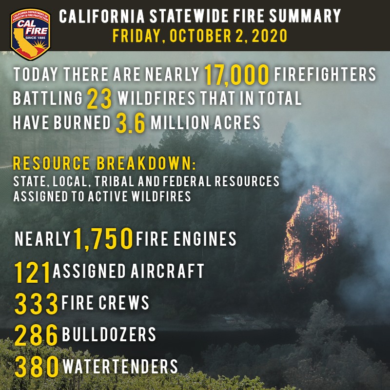
October 2, 2020 - As nearly 17,000 firefighters continue to work towards containment on 23 major wildfires across the state, Red Flag conditions continue throughout the day in parts of California.  Yesterday, crews also responded to 29 new wildfires, bringing full containment to all.
Since the beginning of the year, there have been over 8,200 wildfires that have burned well over 3.9 million acres in California. Currently, over 53,000 residents are evacuated across the state. The total number of fatalities statewide increased again yesterday to a total of 31 after another victim of the LNU Lightning Complex succumb to their injuries. To date, nearly 8,000 structures have been destroyed.
A Red Flag Warning continues through today into Saturday for the North and South Bay, Southern Mendocino County, Western Lake County and Western Monterey County for locally gusty winds and low humidity. High temperatures also persist, adding to the critical fire weather danger. A slight cooling trend is not expected until later in the weekend or early next week.
California historically experiences some of the most devastating wildfires in the months of September and October. Do not let your guard down! To learn more ways on how to prevent sparking a wildfire, visit www.ReadyForWildfire.org.
Fires of Interest
**CAL FIRE Incidents**
Zogg Fire, Shasta County (more info…)
Southwest of Redding
*56,018 acres, 46% contained
*4 Fatalities
*Evacuation orders in place
*CAL FIRE Team 2 in command.
Glass Fire, Napa and Sonoma County (more info…)
4 miles east of Calistoga
*60,148 acres, 6% contained
*Evacuation orders in effect and additional evacuations in progress
*CAL FIRE Team 3 in command.
Butte/Tehama/Glenn (BTU/TGU) Lightning Complex, multiple Counties (more info…)
Butte, Tehama and Glenn Counties
*19,609 acres, 97% contained
*14 structures destroyed
*While no growth is expected, fire suppression repair work is ongoing.
**Unified Command Incidents**
North Complex, Plumas County (more info…)
Northeast of Oroville to southwest of Quincy (Plumas National Forest)
*316,685 acres, 79% contained
*15 fatalities
*2,342 structures destroyed
*Evacuations in place
*Includes the Bear and Claremont Fire
*CAL FIRE Team 4 is in unified command with US Forest Service IMT Team 4, Butte County Sheriff’s Office and California State Parks.
Martindale Fire, Los Angeles County (more info…)
Bouquet Canyon, Northeast of Santa Clarita
*230 acres, 95% contained
*Structures threatened
*Evacuation orders remain in place
*Unified Command USFS and Los Angeles County FD.
Creek Fire, Fresno County (more info…)
Northeast of Shaver Lake (Sierra National Forest)
*311,703 acres, 45% contained
*Evacuations in place
*Heavy tree mortality in the area
*852 structures destroyed
*CAL FIRE Incident Management Team 1 in unified command with USFS Great Basin Team 1.
SQF Complex, Tulare County (more info…)
3 miles east of Giant Sequoia National Monument
*153,226 acres, 61% contained
*Evacuations in place
*232 structures destroyed
*CAL FIRE Incident Management Team 6 in unified command with USFS Team 2.
**Coordinated Command Incidents**
August Complex, Tehama County (more info…)
Colusa, Glenn, Lake, Mendocino, Tehama and Trinity Counties
Elk Creek and Stonyford area (Mendocino National Forest)
*970,563 acres, 51% contained
*South Zone 490,748 acres, 70% contained
*North Zone 356,487 acres, 32% contained
*West Zone 123,328 acres, 55% contained
*1 fatality
*159 structures destroyed
*Includes multiple fires including the Elkhorn, Hopkins, Willow, Vinegar, and Doe fires
*Pacific North West Team 2 in command of the South Zone
*Alaska Incident Management Team 1 is in command of the North Zone
*CAL FIRE Incident Management Team 5 is in unified command on the West Zone.
**Federal Incidents**
Snow Fire, Riverside County (more info…)
Snow Creek Rd, west of Palm Springs
*6,254 acres, 95% contained.
El Dorado Fire, San Bernardino County (more info…)
West of Oak Glen (San Bernardino National Forest)
*22,744 acres, 93% contained
*1 fatality
*10 structures destroyed
*California Interagency Incident Management Team 13 in command.
Slater Fire, Siskiyou County, (more info…)
5 miles North of Happy Camp (Klamath National Forest)
*154,445 acres, 50% contained
*2 fatalities
*Evacuation orders in place.
Devil Fire, Siskiyou County, (more info…)
5 miles north of Upper Devil’s Peak (Klamath National Forest)
*8,506 acres, 20% contained.
Bobcat Fire, Los Angeles County (more info…)
North of Duarte (Angeles National Forest)
*114,901 acres, 79% containment
*Evacuations in place.
Dolan Fire, Monterey County (more info…)
Hwy 1, 10 miles south of Big Sur (Los Padres National Forest)
*124,924 acres, 90% contained
*Structures threatened
*California Interagency Incident Command Team 15 in command.
Bullfrog Fire, Fresno County (more info…)
SE of Bullfrog Lake (Sierra National Forest)
*1,185 acres, 50% contained.
Fork Fire, El Dorado County, (more info…)
15 miles northeast of Pollock Pines (El Dorado National Forest)
*1,667 acres, 70% contained.
Apple Fire, Riverside County (more info…)
Oak Glen/Cherry Valley (San Bernardino National Forest)
*33,424 acres, 95% contained.
Red Salmon Complex – Humboldt County (more info…)
14 miles northeast of Willow Creek (Shasta-Trinity National Forest)
*129,191 acres, 31% contained.
Blue Jay Fire, Mariposa County (more info…)
Yosemite National Park Wilderness
*5,335 acres, 50% contained.
Wolf Fire, Tuolumne County (more info…)
Yosemite National Park Wilderness
*1,092 acres, 60% contained.
Woodward Fire, Marin County (more info…) (FINAL)
3 miles southwest of Olema (Point Reyes National Seashore)
*4,929 acres, 100% contained.
Slink Fire, Mono County (more info…)
2 miles west of Coleville (Humboldt-Toiyabe National Forest)
*26,759 acres, 86% contained.
Moraine, Tulare County (more info…)
Sequoia and Kings Canyon National Parks Wilderness
*668 acres, 70% contained.
Rattlesnake, Tulare County (more info…)
Sequoia and Kings Canyon National Parks Wilderness
*4,471 acres, 30% contained.
**Extended Attack**
Copper Fire, Amador County (more info…)
4 miles west of Rancho Murieta
*48 acres, 70% contained.
Top 20 Wildfire Records
• 5 of the Top 20 largest wildfires in California History have occurred in 2020.
• Largest Wildfires - #1 August Complex, #3 SCU Lightning Complex, #4 LNU Lightning Complex, #5 North Complex, and #6 Creek Fire.
• Most Destructive - #5 North Complex, #10 LNU Lightning Complex, #11 CZU Lightning Complex, and #17 Creek Fire.
• Deadliest Wildfires - #5 North Complex and #20 LNU Lightning Complex.
Source: CAL FIRE
