


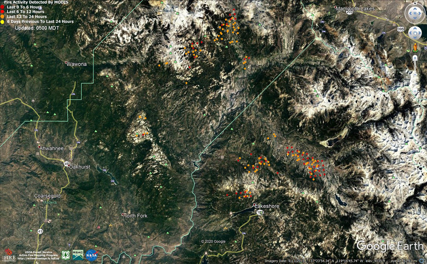
MODIS map of the Creek Fire on Monday at 4:00 A.M. PST
Note: 1,500 Wide and older yellow detections removed
MODIS Active Fire Mapping Program Frequently Asked Questions
Update 7:50 P.M. CAL FIRE Evening Update for the Creek Fire: 322,774 acres and 49% containment, with 119 structures threatened.
'Click' here to view 4 page PDF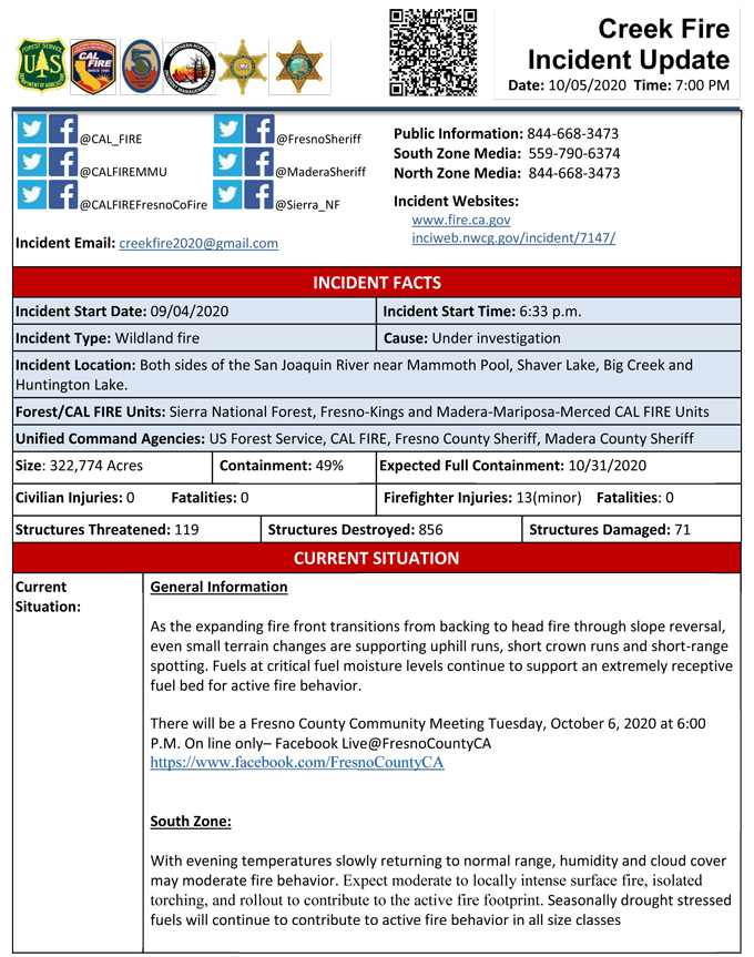
Update 7:00 P.M. (LIVE) Sierra National Forest to Hold a Creek Fire Livestream Incident Briefing with CAL FIRE on Monday, October 5, 2020
Update 5:55 P.M. Per Madera County Sheriff’s Office: If you were affected by the Creek Fire and are in need of recovery resources, please go to the Oakhurst Community Center (39800 Fresno Flats Road) on Thursday, October 8, between 10:00 A.M. and 2:00 P.M.
Update 10:00 A.M.: Sierra National Forest Creek Fire Operations South Zone Briefing Video for Monday, October 5, 2020
Update: 8:10 A.M. Forest Service Wildland Fire Smoke/Air Quality Outlook Due to the Creek Fire in the Yosemite Area for October 5 &6, 2020
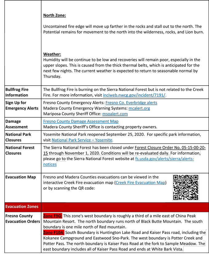
Update 8:00 A.M.: CAL FIRE morning update: 322,089 acres and 48% containment, with 119 structures threatened.
Note: No PDF attachment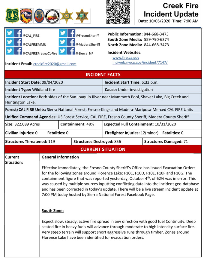
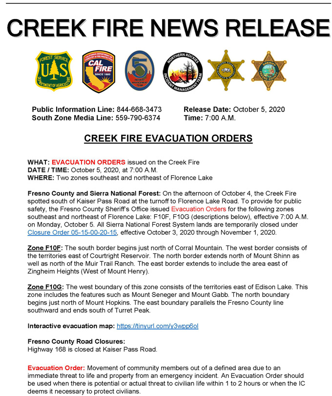
Update 7:30 A.M. Per CAL FIRE Creek Fire Evacuation Orders for Two Zones Southeast and Northeast of Florence Lake
See the Interactive Map
Update 5:20 A.M.: Sierra National Forest Creek Fire Operations Map for Monday, October 5, 2020 - Shows Divisions, Uncontrolled Fire Edge, Completed Dozer Lines, Proposed Dozer Lines
October 5, 2020 - Overnight infrared mapping has the Creek Fire at 322,089 Interpreted Acres.
Comments and notes on flight:
North Zones Div. G & J continue to have similar scattered heat profiles as previous flights, while Div. J and M along have perimeter growth and intense heat, especially along the northern tip and throughout Div. J. Additional growth was detected at the furthest eastern point near Div. P and N. Two hottest portions of the fire continue to be the northernmost tip (Div. J/Div. M break) and along the easternmost tip (Div. N). Portions of the interior of the fire to the south (Div. P and R) appear to be warming up: heat within the scattered heat polygons is warmer and denser.
One of the unburned islands in Div. M shrunk as heat encroached upon it, although a few more unburned islands in both the northern and southern portions of the fire were detected. Two additional unburned islands were detected in Div. N near the hottest area of furthest spread, around Mono Hot Springs.
Finally, the perimeter obtained as a base with which to conduct this evening’s mapping mission was pulled from the NIFC AGOL server. Upon return from the flight (on. 10/05/20 @ apx. 0000) a new perimeter had been emailed to me at 2200 on 10/4 while the mission was being conducted. Best attempts were made to synchronize all data to construct the most up-to-date perimeter. There was some spread from the 2200 supplied perimeter in pockets throughout the fire. However, spread annotated in Div. N/ Div. P in the 2200 supplied perimeter was greater than that detected in the heat imaging. The supplied perimeter is mapped with that annotated spread. However, calculations on fire growth took place using the 2200 supplied perimeter.
Sunday Evening Update: 316,673 acres and 49% containment.
Sierra National Forest Creek Fire Updates for Sunday, October 4, 2020

