


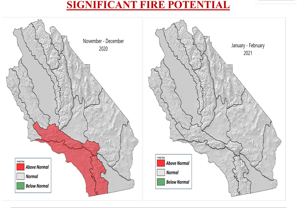
- Temperatures well above normal through December then cooling to a little above normal in January and February.
- Well below normal rainfall through December then a little below normal rainfall in January and February.
- Above normal offshore wind events through December then near to a little below normal offshore wind events in January and February.
Weather and Fuels Discussion
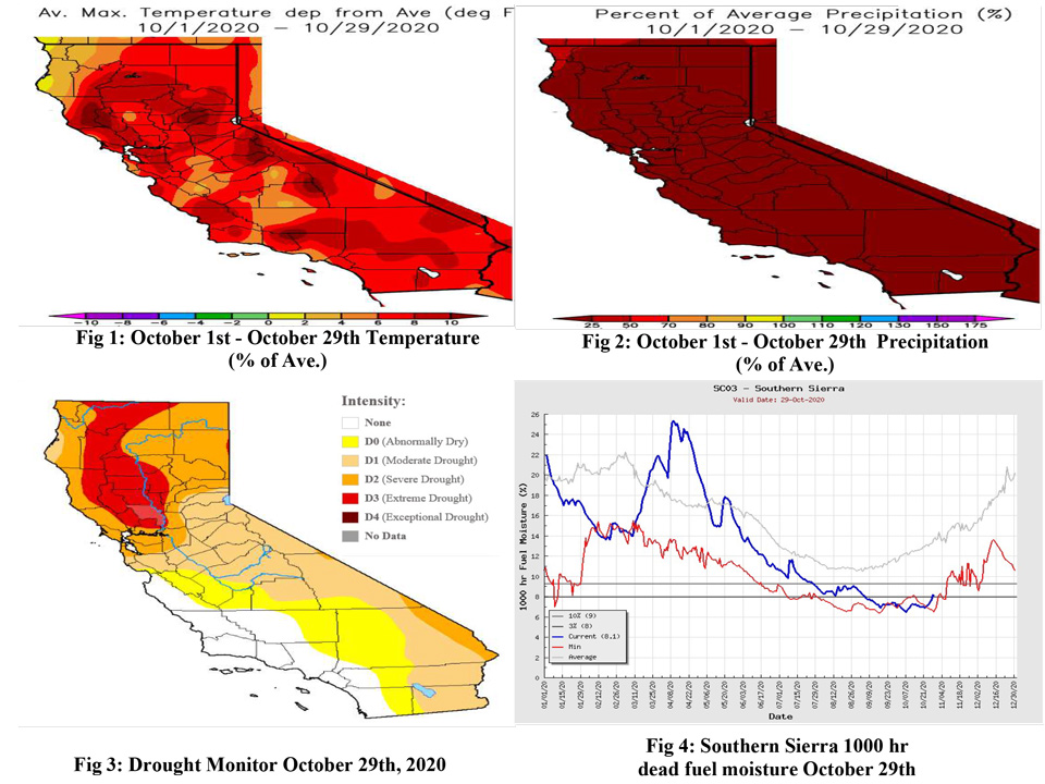
November 2, 2020 - High pressure remained the dominant weather feature across Central and Southern California in October just like in September, but the center of high pressure moved from over the Great Basin and Desert Southwest to off the California Coast. This area of high pressure brought above normal temperatures to most locations for most of the month. However, a couple of Pacific troughs brought brief periods of near to a little below normal temperatures from October 8th – October 11th and from October 22nd – October 26th. The high pressure was at its strongest the first couple days of the month when widespread temperatures in the valleys were between 100 and 110 degrees and many record high temperatures were broken. Overall, temperatures for October were well above normal (Fig 1). There were no weather systems that brought widespread rainfall to the area and most locations received no rainfall at all (Fig 2). There was one strong and one weak Santa Ana wind event this month. The strong event occurred from October 26th – October 27th and the weak event occurred on October 16th. With the strong event, northeast winds of 20 to 40 mph with gusts to 60 mph surfaced across the mountains and below the canyons and passes of Southern California. The windiest locations had gusts to 80 mph. There was no change to the drought situation across the region in October (Fig 3). Moderate drought to abnormally dry conditions continued across interior portions of Central California north of Kern County and across the deserts. There was no drought along the Central Coast and from the mountains westward from Kern County all the way south to San Diego County. The fuels remained very dry in October. 1000-hour dead fuel moisture remained mainly below the 3rd percentile across the mountains (Fig 4). 100-hour dead fuel moisture was more variable in October but was below the 3rd percentile and broke records at the beginning of the month (Fig 5 below). There was little change in the live fuel moisture this month (Fig 6 below). The live fuels remained mainly between 50% and 70%, but some of the old growth live fuel moisture was between 40% and 50%. These live fuel moisture values are below normal for this time of year
South OPS Outlook
Even though sea surface temperatures have cooled some in the Gulf of Alaska, Central and Southern California will most likely receive well below normal precipitation and well above normal temperatures through December as sea surface temperatures along the West Coast remain well above normal and sea surface temperatures over the Equatorial Pacific remain well below normal (Fig 7). High pressure off the California Coast is expected to remain the dominant weather feature affecting Central and Southern California through December. Pacific troughs dropping down the east side of the high-pressure area located just off the California Coast will likely bring stronger and more occasional Santa Ana wind events to Southern California in November and December. Thus, the significant large fire potential will remain above normal across Southern California from the mountains westward through December. Offshore winds are much less common across Central California and since heat waves are uncommon and not long-lasting during the fall months, the large fire threat was lowered to normal across Central California. Forecast models predict that sea surface temperatures off the West Coast will cool and sea surface temperatures over the Equatorial Pacific will warm during the winter months which will allow for cooler temperatures and beneficial precipitation to occur. Thus, the significant large fire threat is expected drop to normal across the entire region in January and February.
Source: Climate Prediction Center
