


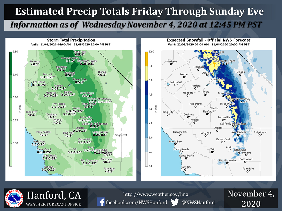
Projected rainfall totals for Mariposa: 0.50" to 1.00"
Projected rainfall totals for Oakhurst: 0.50" to 1.00"
Projected rainfall totals for Yosemite Valley: 1.00" to 1.50"
November 4, 2020 - The National Weather Service Hanford Office reports a cold storm system will bring snow to the mountains and rain to the lower elevations Friday through the weekend along with blustery winds through and below the passes.
Many roads will be rain-slicked in the San Joaquin Valley and adjacent foothills this weekend while winter driving conditions can be expected in the mountains above 5, 000 feet.
Area Forecast Discussion
National Weather Service Hanford CA
429 AM PST Wed Nov 4 2020
  .SYNOPSIS...
  Warm dry conditions are expected to continue through Thursday. A
  very cold system will move into the region on Friday, bringing a
  chance of precipitation to the entire region. Unsettled
  conditions will continue through the weekend, with well below
  average temperatures and continued chances of precipitation. A
  trough pattern will remain in the region into next week, with
  below average temperatures continuing across the area.

  &&


  .DISCUSSION... A big change to the current weather pattern is
  finally in store for the central California interior by the end of
  the week! But before then, we will have a few more days of well
  above average temperatures and continued dry conditions. An upper
  level high will move into the region today. This high pressure
  will then move into the southern Rockies on Thursday. Afternoon
  high temperatures for today and Thursday will remain between 6 to
  10 degrees above average. With the light winds aloft, smoke and
  haze will continue to impact the area.

  A deep trough will drop southward from the Gulf of Alaska during
  Friday, with the main core of the 500mb low reaching NorCal by
  Friday night. A strong cold front will move into the northern
  half of the district by Friday morning, eventually reaching Kern
  county by the afternoon. Strong southwesterly winds will develop
  ahead of this front. This will temporarily enhance fire weather
  concerns in the Sierra and Kern county mountains until
  precipitation moves into the region. Precipitation will become
  likely for the Yosemite area by Friday morning and into Tulare
  county by the evening with snow levels falling to around 5,000
  feet by Friday night. Temperatures on Friday will be up to 15
  degrees cooler compared to Thursday.

  Models are showing the main cold core of the upper low dropping
  through the central California interior on Saturday. Light
  precipitation will be possible throughout the entire area with
  the best chances remaining in the Sierra and Kern county
  mountains. With the cold air aloft, snow levels in the mountains
  will continue to drop to near 4,000 feet by Saturday afternoon.
  Temperatures will drop even further on Saturday, with only mid to
  upper 50s in the valley and desert. A second trough is progged to
  drop southward through the area on Sunday into Monday. This will
  once again increase our chances of precipitation throughout the
  region, with snow levels reaching to as low as 3,000 feet.
  Temperatures for Sunday and Monday will struggle into the mid 50s
  in the valley and desert. A trough pattern remains in place into
  the middle of next week, as the region continues with below
  average temperatures.
Source: NWS

