


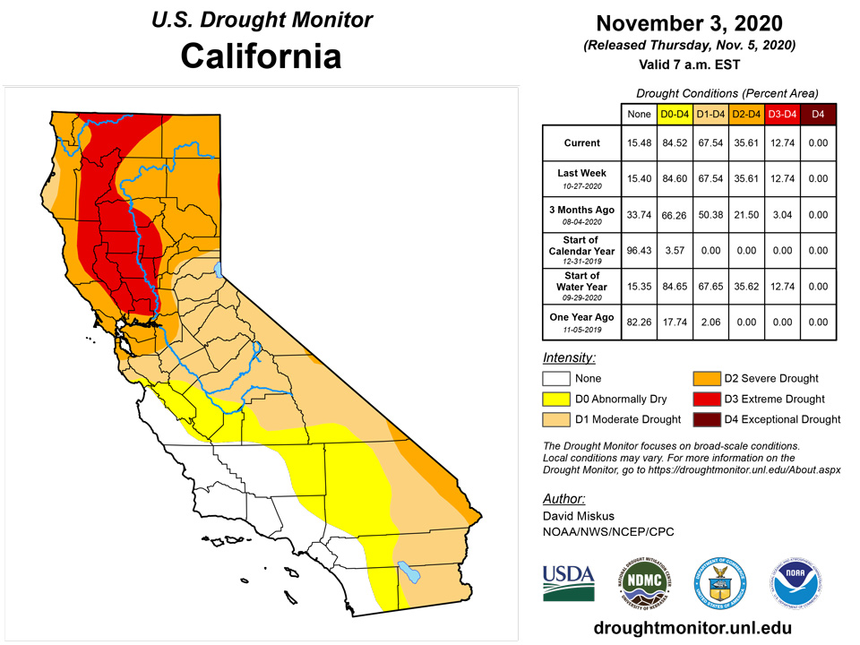
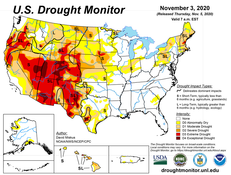
California and National Drought Summary for November 3, 2020
Summary
November 5, 2020 - Hurricane Zeta made landfall near Cocodrie in southeastern Louisiana during the late afternoon on Wednesday, October 28, as a Category 2 hurricane with sustained winds estimate at 110 mph. With a fast northeastern track that took it off the mid-Atlantic Coast in about 24 hours, the rapid pace limited rainfall totals along its track to between 2 and 4 inches, with locally heavier amounts in southern Mississippi and Alabama of up to 8 inches. Unfortunately, the fast pace delayed the weakening of Zeta’s winds, and widespread wind damage and power outages occurred along Zeta’s path, even into the mid-Atlantic. In addition as the period started, an upper-air low over the southern Rockies slowly tracked eastward, becoming infused with tropical moisture from Zeta and the Gulf of Mexico. It dumped 1.5 to 3.5 inches of precipitation, locally to 5 inches, from the western Oklahoma and northern Texas Panhandles eastward across northern Oklahoma and southern Kansas, southern Missouri and northern Arkansas, and into the Ohio and Tennessee Valleys. Although the precipitation was very beneficial to the winter wheat crop and pastures, some of the precipitation fell in the form of snow and freezing rain in western Texas, Oklahoma, and Kansas, causing damage. Once the upper-air low and Zeta cleared the East Coast, much drier and colder air rushed into the Northeast and Southeast, with light snow accumulating across parts of western New England and upstate New York. Elsewhere, little or no precipitation occurred in the Far West, Southwest, Rockies, southern and northern Plains, and upper Midwest. Subnormal weekly temperatures enveloped the Midwest, southern and central Plains, and Northeast, while the West, Rockies, and Southeast experienced near to above-normal readings. Welcome showers fell across most of Puerto Rico while drought expanded across portions of Hawaii’s Big Island.
Northeast
Precipitation returned to much of the Northeast, especially southern and eastern sections, after drier weather last week. As the remnants of Zeta and the upper-air low tracked across the mid-Atlantic, 1-3 inches of rain fell on most of West Virginia, Pennsylvania, Maryland, Delaware, New Jersey, southern New York, Connecticut, Massachusetts, Rhode Island, southern New Hampshire, and eastern Maine. The rains brought most 7-day average USGS stream flows up into the normal range, although some gauges at 14- and 28-days were still below normal in western New York, central Pennsylvania, and portions of coastal New England. With the precipitation, some drought was trimmed where the heaviest rains occurred and the 60- to 90-day deficits were greatly decreased or alleviated. However, there were still some decent long-term deficits at 6-months (8-12 inches in eastern parts of New England), prompting some restraint when making improvements. These improvements included a reduction of D1 and D0 in northern West Virginia and southern Pennsylvania; D0-D2 slimming in central and northern Pennsylvania; D3 removal in Rhode Island and eastern Massachusetts; a slight D3 reduction in southern New Hampshire; D2 shrinkage in Maine, southern New Hampshire, eastern Massachusetts, Rhode Island, and eastern Connecticut. Slight additional improvements (D0-D2) occurred in central and northern New York, western Vermont, and central Maine
Southeast
Fast-moving Hurricane Zeta dropped moderate to heavy rains (2-4 inches, locally 8) on the western and northern sections of the Southeast, while scattered showers (1-2.5 inches) fell on parts of Florida and southern Georgia. Little or no rain was measured in central sections of Georgia, South Carolina, and eastern North Carolina. The small D0 areas in southeastern Mississippi, southwestern Alabama, and southeastern Louisiana were effectively erased by heavy rains from Zeta, except for western portions in southeastern Louisiana that missed out on the rain. In eastern Georgia and southwestern South Carolina, a small band of rain from Zeta dropped 1-3 inches of rain on the southern section of the D0 area there, erasing some of the D0. Short-term dryness continued to linger from 2-6 months there, but wetter conditions prevailed past 6-months. Short and long-term precipitation across much of the Southeast remained close to or above normal, including a record 5 tropical storms making landfall in Louisiana this year.
South
As the week started, the upper-air low over the southern Rockies tapped Gulf moisture, bringing welcome and beneficial precipitation (1.5-5 inches) to the south-central Plains. Unfortunately, the demarcation of the haves versus have-nots was sharp, with southern Kansas, the northern half and far eastern Oklahoma, and the Panhandles of Oklahoma and Texas coming out favorably. Accordingly, the copious precipitation resulted in 1- and 2-cat improvements, particularly in northwestern Oklahoma where 3-5 inches fell, including some light amounts the previous week. Western Texas, much of it in D3-D4, did receive some light precipitation (0.25-1 inch), but could have used a lot more, and improvements were minimal. In contrast, little or no precipitation fell on the southern half of Texas for the second consecutive week, resulting in additional degradation. October is normally one of the wetter months in south-central Texas, so with many locations measuring less than 25% of normal the past 30 days, short-term deficits have rapidly accumulated. USGS 7-day average stream flows have also picked up on the dryness, with many gauges in the much below category (less than tenth percentile).
Midwest
While the northern and western sections of the Midwest were dry and cold, additional heavy precipitation, courtesy of the upper-air low, dropped light to moderate precipitation (1-3 inches) across southern and eastern portions of the region, with greater totals (3-5 inches) measured in southern sections of Missouri, Illinois, Indiana, and western Kentucky. With copious precipitation falling during the past 2 weeks (200-400% of normal), much of southern Missouri, especially the southwest corner, has seen a rapid elimination of drought and abnormal dryness, as have parts of the lower Ohio Valley. In contrast, abundant precipitation has missed northern sections of Missouri, central Illinois, and northwestern Indiana the past 2 weeks, and even out to 90-days, thus D1 was slightly extended westward and northward in central Illinois, and across much of northern Missouri. Elsewhere, cold conditions (weekly temperatures 6 to 12 degrees F below normal) and light precipitation recorded the previous week was enough to maintain conditions.
High Plains
With much of the region cold and dry this week, status-quo was the norm for most states that either received precipitation 2 weeks ago (Wyoming, Montana, the Dakotas), or deteriorations were made (North Dakota). Unfortunately, southern Nebraska and northern Kansas missed out on precipitation during late October, thus some degradations were made there. With short-term (out to 90-days) SPIs much drier than D1, and 90-day precipitation less than half of normal - producing 4-6 inch deficits - D1 was extended across northern Kansas and into southeastern Nebraska. D2 was slightly expanded into northwestern Kansas and southwestern and northeastern Nebraska. Wetter conditions at 4-months limited the deteriorations made this week, along with a dry climatology during October and November. In contrast, the upper-air low that trekked from the southern Rockies to the mid-Atlantic and became infused with Gulf moisture courtesy of Hurricane Zeta dumped welcome and heavy precipitation (1-4 inches) across southern Kansas, effectively allowing a 1-category improvement across the southern third of the state. The middle third of Kansas remained unchanged.
West
Dry weather prevailed across the entire West, with only light precipitation (less than 2 inches) reported in western Washington and the extreme northern Cascades. Temperatures gradually increased during the week, with most locations averaging at or above-normal weekly anomalies. With beneficial precipitation falling the previous week (Oct. 21-27) across the Northwest and Rockies, no deteriorations were made this week where precipitation fell in late October. However, with two consecutive weeks of no precipitation, the wet season that should be in full swing by now, and lingering long-term impacts, some slight deterioration was made in Oregon (D2 and D3 expansions) and southwestern Idaho (Elmore County to D1). In northern Colorado, D4 was expanded into northern Routt and northern Grand Counties which missed significant precipitation 2 weeks ago, with SPIs, evaporative demands, and precipitation out to 6-months at D4 levels. No changes were made in the Southwest as October and November are climatologically dry. In contrast, additional investigations to last week’s precipitation called for improvements to central Idaho (D0 removed in Clearwater Basin) and south-central Colorado (D3 and D2 reductions) from recent precipitation and overall favorable impacts.
Alaska, Hawaii, and Puerto Rico
In Alaska, colder and drier weather enveloped much of the state, with significant precipitation (2 to 6 inches, locally more than 10 inches) limited to the southeastern Panhandle. Light snow fell on northwestern areas of the North Slope, removing some D0 there. Elsewhere, with dry and cold conditions this week, it was status-quo for the remaining D0 areas in the south and northwest and small D1 near Kotzebue.
In Hawaii, drier weather returned to the islands as most of the showers ended last Tuesday. On Kauai, the 2-week NDVI showed improvement on the west side, thus D2 was trimmed some, but degraded vegetation on south-facing slopes maintained D1 there. Additionally, stream flows on the north side of the island (Hanalei and Wainiha Rivers) were very low as this area missed out on the recent Kona low rain event, prompting D1 development on the north side of Kauai. No changes were made for Oahu and Maui, but there were reports that axis deer and cattle in west Molokai have died due to lack of water. On the Big Island, an expansion of D1 and D2 from the northwest to southeast was made in response to poor vegetative conditions from the NDVI to encompass the upper slopes of Mauna Kea.
Widespread light to moderate showers (1-3 inches), locally to 7 inches in the southeast, dampened most of Puerto Rico. The three separate D0 areas on the island (northwest, southwest, south-central) were shrunk as decent rains fell on parts of the abnormally dry areas, decreasing or eliminating short-term deficits. In the northwest, however, lighter weekly totals (less than an inch) slightly expanded the D0 into northern Camuy and Hatillo where 60-days deficits were at 2-4 inches.
Pacific Islands
The weather across the U.S.-Affiliated Pacific Islands (USAPI) during this USDM week (10/28/20-11/03/20) was influenced by surface troughs, tropical disturbances, and circulations, some of which intensified into tropical depressions as they trekked across Micronesia. One developed into Typhoon Goni west of the Marianas. Precipitation from the surface troughs and circulations was enhanced by divergence aloft associated with upper-level troughs and lows over western Micronesia. La Niña inhibited precipitation in extreme southern Micronesia, an Inter-Tropical Convergence Zone (ITCZ) briefly developed in eastern Micronesia, and a monsoon flow was set up briefly over western Micronesia as Tropical Depression Atsani and Super Typhoon Goni moved west of the region. South of the equator, a surface trough slowly moved across the Samoan Islands. Satellite-based estimates of 7-day precipitation (QPE) showed the climatological bands of precipitation, associated with the climatological ITCZ, stretching eastward from Indonesia across Micronesia and beyond the Date Line, and the climatological bands of precipitation, associated with the South Pacific Convergence Zone (SPCZ), extending southeastward past the Samoan Islands. Bands of 2+ inches of rain were indicated on the QPE maps over parts of Micronesia, with embedded 4+ inch areas and surrounded by precipitation of one inch or less. A large band of 2+ inches, with embedded 4+ inch areas, paralleled the Samoan Island chain to the north and east, quickly tapering off to an inch or less across and west of the Samoan Islands.
Palau had a wet week, with rainfall totals surpassing its 2-inches weekly threshold to meet most water needs at the Palau IAP and the Koror COOP. D-Nothing continued at Palau.
The Marianas also had a wet week, receiving over 1-inch of rain. Guam had the least rainfall at 1.08 inch. Meanwhile, Saipan and Rota had 1.72 and 1.78 inches of rain, respectively. D-Nothing was unchanged for the three locations.
Several locations (Yap, Kosrae, Nukuoro, Pingelap, Ulithi, and Woleai) across the Federated States of Micronesia had a very wet week, with rainfall totals over 3 inches. Kosrae had the highest rainfall total at 5.93 inches. For these locations, drought was not a concern. Meanwhile, Chuuk Lagoon, Fananu, and Lukunor had less than 2 inches of rain to meet most water needs, but continued in drought free conditions for another week. Kapingamarangi continued its dry streak, receiving only 0.34 inch of rain this week, securing another week of exceptional drought (D4-S).
The Marshall Islands also had a wet week, with most locations receiving over 2 inches of rain. Ailinglaplap had the most rain at 4.33 inches for the week, while Jaluit had the least rain at 1.25 inches. Ailinglaplap, Kwajalein, Majuro, Jaluit, Mili, and Wotje remained in drought free status.
American Samoa had a wet week, with over 2 inches of rain at Pago Pago and Suifaga Ridge. Toa Ridge had 1.78 inches of rain for the week. D-Nothing continued at Tutuila.
Virgin Islands
This was a dry week for St. Croix, receiving less than half an inch of rain at the Henry Rohlsen airport and between 0.37-0.73 inch at the different CoCoRaHs locations. Although this was a dry week, SPI at the 1, 3, 6 and 9 month period is indicative of drought free conditions, while the 12 months SPI value of -0.74 is indicative of abnormally dry conditions. St. Thomas' Cyril E. King Airport had 0.58 inch of rain for the week, while the different CoCoRaHs locations across St. Thomas had 1.06-1.60 inches of rain. Similarly, SPI values at the 1 and 3 months is indicative of drought free conditions, while the 6, 9, and 12 months were indicative of abnormally dry conditions. Meanwhile, St. John had the most rain this week, with rainfall totals between 1.28 and 1.85 inches of rain at the different CoCoRaHs locations. SPI at the 1, 3, 6, 9, and 12 month period were indicative of drought free conditions. For this week, drought free conditions were unchanged for all three locations.
Looking Ahead
During the next 5 days (November 5-9), a change in the upper-air pattern should bring unsettled weather (cold and wet) to the West, including moderate to heavy totals (1-3 inches) to the Cascades, Sierra Nevada, and Rockies, according to WPC’s 5-day QPF. Light rain is expected in the upper Midwest, while moisture from the remnants (or reformation) of Hurricane Eta (currently in Central America) will soak southern Florida. The rest of the contiguous U.S. should be mostly dry. Temperatures during the next five days will average above-normal for much of the Nation (from the Rockies eastward), while cooler weather envelops the Far West.
The Climate Prediction Center’s 6-10 day outlook (November 10-14) favors above-normal precipitation across Alaska, the Northwest, Midwest, and East Coast. Subnormal precipitation was limited to the northern Plains, with equal chances elsewhere. Odds for subnormal temperatures are quite likely across the West, Rockies, and High Plains, while above-normal readings are strongly favored in the eastern third of the Nation.
Author(s):
David Miskus, NOAA/NWS/NCEP/CPC
Ahira Sanchez-Lugo, NOAA/NCEI
Dryness Categories
D0 Abnormally Dry—used for areas showing dryness but not yet in drought, or for areas recovering from drought.
Drought Intensity Categories
D1 Moderate Drought
D2 Severe Drought
D3 Extreme Drought
D4 Exceptional Drought
Drought or Dryness Types
S Short-Term, typically less than 6 months (e.g. agricultural, grasslands)
L Long-Term, typically greater than 6 months (e.g. hydrologic, ecologic)
Source: National Drought Mitigation Center

