


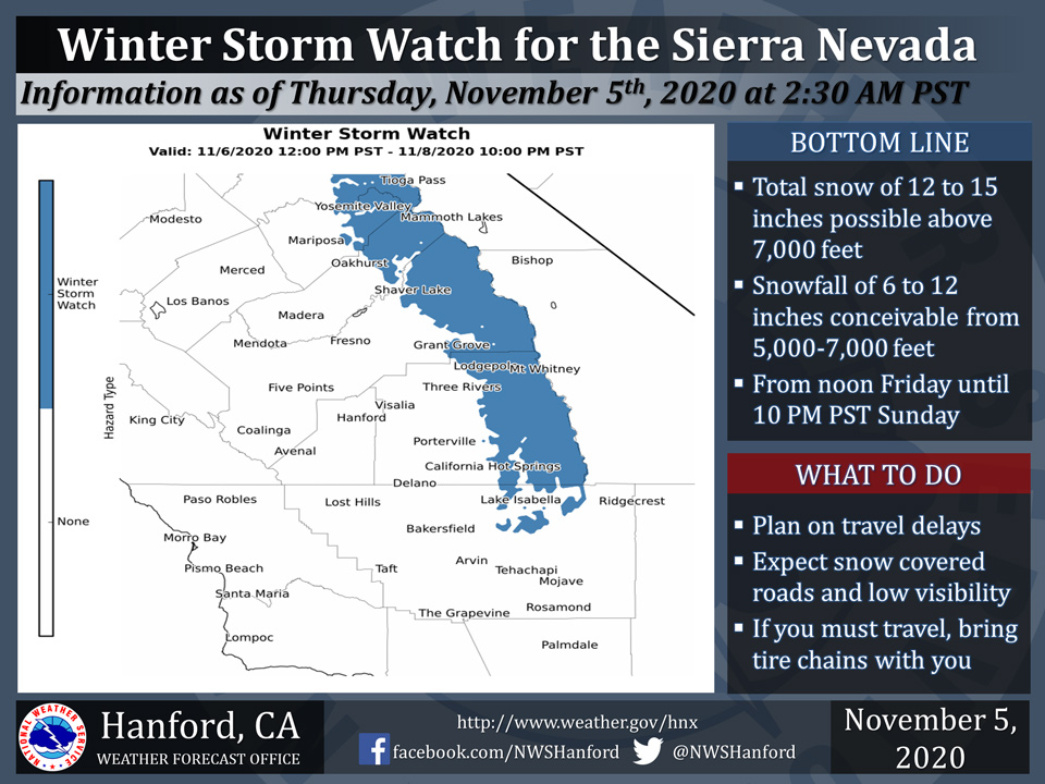
November 5, 2020 - The National Weather Service Hanford Office reports a Winter Storm Watch is in effect for the Sierra Nevada above 5,000 feet from 12:00 PM Friday afternoon until 10:00 PM Sunday night.
The majority of this snow will fall Saturday afternoon through Sunday morning.
Winds could gust as high as 60 mph on exposed ridgetops and near the crest.
If you plan to travel, consider alternate strategies.
If you must travel, remember to carry tire chains, plenty of food, a good deal of water, and warm clothing in your vehicle.
For information on road conditions, including closures or delays, call Caltrans at 1-800-427-7623.
  Area Forecast Discussion
  National Weather Service Hanford CA
  436 AM PST Thu Nov 5 2020


  .SYNOPSIS...
  One last day of above average temperatures and dry weather.
  Unsettled weather will move into the region on Friday and will
  continue into Sunday.Temperatures will plummet across the area,
  up to 15 degrees below average. A trough pattern will continues
  into next week with below average temperatures.


  &&

  .DISCUSSION...
  We`ll see one last day of unseasonably warm, dry conditions
  across the central California interior before a very big change is
  in store for the region. An upper level high currently over the
  southern Great Basin will quickly move into the southern plains
  by tonight as a deep trough starts to dig southward into NorCal.
  Today`s high temperatures will continue to be up to 10 degrees
  above average, with haze and smoke from local wildfires continuing
  to affect the area. Smoke will start to clear by later tonight as
  southwesterly winds increase ahead of the approaching trough.

  As the aforementioned trough digs into NorCal, strong south to
  southwesterly winds will develop in the higher elevations of the
  Sierra Nevada and Kern county mountains. These strong winds ahead
  of a cold front will occur prior to the onset of the heaviest
  precipitation. This will combine with the very dry conditions
  across the region, which will create a period of elevated fire
  weather conditions, primarily from later this evening into Friday
  morning.

  The High Resolution Ensemble Forecast system (HREF) as well as
  deterministic model solutions have continued to move the main
  upper level low further to the west, which favors a wetter system.
  The guidance has continued to pick up on this solution and
  precipitation amounts have increased across the area. Rain and
  snow will form by Friday morning in the Yosemite/Merced county,
  moving south into Kern county by Friday evening as a strong cold
  front sweeps through the region. Total QPF amounts for Friday
  range between a trace to 1/10 of an inch in the valley, 1/10 to
  1/4 of an inch in the foothills, and between 1/4 to 3/4 of an inch
  in the higher elevations, with the highest amounts from Fresno
  county northward to Yosemite. QPF amounts in Kern county will be
  lighter, with no precipitation expected in the desert. Snowfall
  will increase in intensity over the course of the day Friday,
  with snow levels plummeting to around 5,000 feet by the evening.
  Between 2 to 4 inches will be possible by Friday night, primarily
  from Fresno north into Yosemite, with lighter amounts to the
  south.

  The main cold core of the upper level low will swing south
  through the central California interior on Saturday. Rain and
  snow above 5,000 feet will be likely for the higher elevations of
  the Sierra and Kern county mountains throughout a majority of the
  day, with a chance of precipitation in the valley and Kern
  county desert. QPF amounts are generally between another trace to
  1/10 of an inch in the valley, 1/10 to 1/4 of an inch in the
  mountains, and a trace to less than 1/10 of an inch in the desert.
  Light snow will continue through the day above 5,000 feet with an
  additional 1 to 3 inches for a majority of mountain locations.

  By Sunday, another very cold system will drop south into the
  central California interior. This system has also become wetter
  compared to prior runs. QPF amounts on Sunday range between 1/10
  to 1/4 in the valley, 1/4 to 1/2 inches in the foothills, and 1/2
  to 1 inch in the Sierra, with lighter amounts into Kern county
  mountains. An additional 4 to 8 inches of snow will be possible in
  the Sierra, with 2 to 4 inches in the Kern county mountains. Snow
  levels will be around 4,000 feet for a majority of the day as
  temperatures further decrease across the region.

  Since this is the first major winter storm for the Sierra Nevada,
  a Winter Storm Watch has been issued for the elevations greater
  than 5,000 feet. This watch will be in effect from Friday
  afternoon until Sunday evening. Any travelers heading into the
  high county should prepare for winter like driving conditions.

  A trough pattern will continue across the western U.S. into the
  middle of next, with temperatures remaining well below average. At
  this time, the forecast remains dry from Monday into the middle
  of next week.
Source: NWS

