


California and National Drought Summary for December 8, 2020
Summary
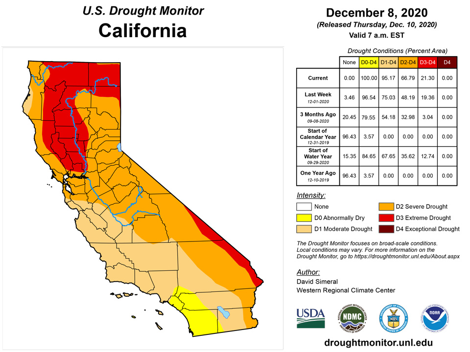
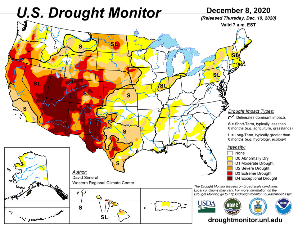
December 10, 2020 - This U.S. Drought Monitor week saw intensification of drought across parts of the western U.S. including California, Nevada, and Colorado where precipitation has been below normal since the beginning of the Water Year (Oct 1). In California, statewide snow water content (SWE) is currently at 36% of the historical average for the date (Dec 7) and Water-Year-to-Date (WYTD) precipitation (statewide) is ranging from the bottom 10% to the bottom 33% with some areas in the Mojave Desert experiencing the driest on record for the period. According to NOAA’s National Centers for Environmental Information (NCEI), the 6-month period from June to November 2020 was the hottest and driest on record for both Arizona and California. Current snowpack conditions across the West are generally reflective of a La Niña-like precipitation pattern with the mountain ranges in the Pacific Northwest and some areas of the northern Rockies observing near-normal to above-normal snowpack conditions. Further south in the Four Corners states, basin-wide (6-digit HUC) SWE is below normal in nearly all drainage basins in the region. Elsewhere on this week’s map, areas of Texas including the Panhandle and central Texas saw some minor deterioration in conditions where both long and short-term precipitation deficits exist. In the Northern Plains, unseasonably warm temperatures and dry conditions continued this week leading to intensification of drought conditions in North Dakota where statewide precipitation for the September-November 2020 period ranked 3rd driest on record, according to NOAA NCEI. In New England, drought-related conditions significantly improved in response to heavy rains and snow associated with a Nor’easter that impacted the region during the weekend. The storm delivered heavy rains and strong winds to coastal areas as well as heavy snowfall in the mountains of New Hampshire and northern Maine.
Northeast
On this week’s map, areas of the region—including Maine, New Hampshire, Massachusetts, Rhode Island, and northern Vermont—saw widespread 1-category improvements in response to this week’s Nor’easter that brought heavy rains and snowfall to the region. For the 7-day period, precipitation (liquid) totals ranged from 1 to 6 inches with the heaviest precipitation observed in Rhode Island, eastern Massachusetts, and along the coastal areas and north-central portions of Maine. Elsewhere in the region, areas of Moderate Drought (D1) in the Adirondack Mountains of New York expanded slightly across areas that have largely missed out on recent storm events. According to the National Operational Hydrologic Remote Sensing Center (NOHRSC), the regional snowpack analysis reports that 60% of the Northeast region is currently covered by snow with an average depth of 2.4 inches and a maximum depth of 20.2 inches.
Southeast
During the past week, scattered precipitation was observed across the region with rainfall accumulations ranging from <1 inch to 3+ inches with areas of Virginia and southern Florida experiencing the heaviest accumulations. Average temperatures for the week were well below normal across much of the region with temperature departures ranging from 4 to 10 degrees F below normal. On the map, the region remained drought free, although some areas of Abnormally Dry (D0) were introduced in northern Alabama as well as portions of Georgia. According to NOAA NCEI climatological rankings, the September-November 2020 period was marked by above-normal precipitation across the Southeast with statewide precipitations ranks (where 1=driest on record and 126=wettest on record) for the period were as follows: Virginia–123, North Carolina–118, South Carolina–107, Georgia–110, Alabama–104, and Florida–117.
South
On this week’s map, areas of drought intensified and expanded in the Panhandle and central Texas where both long and short-term precipitation shortfalls exist. In these areas, 6-month precipitation deficits ranged from 4 to 8+ inches. Conversely, above-normal precipitation during the last 30-day period led to improvements on the map in areas of Moderate Drought (D1) and Abnormally Dry (D0) along the Coastal Plain region of Texas. According to the USDA for the week of November 29, 61% of topsoil moisture in Texas was rated short to very short and 34% of the winter wheat crop was reported to be in poor to very poor condition. Elsewhere in the region, short-term dryness during the past 30-day period led to expansion of areas of Abnormally Dry (D0) across portions of Louisiana, Arkansas, Mississippi, and Tennessee. Average temperatures for the week were well below normal (4 to 10+ degrees F) across the entire region.
Midwest
On this week’s map, some minor expansion of areas of Moderate Drought (D1) occurred in central Illinois in response to short-term precipitation deficits (60 day to 6 months), low streamflows, and areas of below-normal soil moisture. Overall, the region was generally dry during the past week with below-normal average temperatures in the southern half of the region and above-normal temperatures in the northern portion with the greatest positive anomalies (6 to 12+ degrees F) observed in western Minnesota. According to the NOAA NOHRSC, 13% of the Northern Great Lakes region was covered by snow with an average snow depth of 0.2 inches and a maximum depth of 5.4 inches.
High Plains
On this week’s map, areas of the region—including southwestern North Dakota and central Nebraska—saw modest expansion in areas of Severe Drought (D2) as well as expansion in areas of Moderate Drought (D1) in southwestern North Dakota in response to a combination of factors—short-term precipitation deficits, lack of seasonal snow cover, depleted soil moisture, and unseasonably warm temperatures (12 to 20 degrees F above normal)—during the past week. In the eastern Plains of Colorado, areas of Extreme Drought (D3) and Exceptional Drought (D4) expanded where long-term precipitation deficits continued to mount.
West
During the past week, high pressure continued to dominate across much of the region with essentially no precipitation observed except for some light precipitation (generally <1 inch) along coastal Oregon and Washington. On the map, below-normal WYTD precipitation across California led to deterioration across the Sierra Nevada, Central Coast, southern San Joaquin Valley, and areas of Southern California and the Mojave Desert. In the mountains of California, the current statewide SWE for the date (Dec 7) is 36% of normal. Considering the regional breakdown across the state, the current percentage of normal SWE is as follows: Northern Sierra/Trinity–40%, Central Sierra–44%, and Southern Sierra–17%. According to the California Department of Water Resources, the three largest reservoirs in the state were below historical averages for the date with Shasta at 74%, Oroville at 60%, and Trinity at 79%. In the northern Great Basin, areas of Extreme Drought (D2) expanded in northeastern Nevada where snowpack conditions are below normal across the Ruby Mountains, Independence Mountains, and Jarbidge Mountains. Across the Nevada and Utah borders in southern Idaho, areas of Moderate Drought (D1) expanded where below-normal snowpack conditions are being observed in the Bear River Range and the Portneuf Range east of Pocatello, Idaho. In the Pacific Northwest, snowpack conditions at the Sub-region level (4-Digit HUC) ranged from slightly below normal (Lower Snake–78%, Upper Snake–83%, Yakima–84%, Kootenai-Pend Oreille-Spokane–87%, Oregon-Washington Coastal–90%, Upper Columbia–94%, Middle Snake–99%) to above normal (Puget Sound–101%, Willamette–115%, Middle Columbia–117%, Oregon Closed Basins–143%). Across the mountain ranges of the Four Corners states, snowpack conditions are well below normal across with the Little Colorado, Salt, Upper Gila, Rio Grande-Mimbres, Rio-Grande Elephant Butte, Upper Canadian, and Upper Pecos basins—all below ~50% of normal. According to the NRCS (Dec 1), statewide reservoir storage was below normal in Colorado, Nevada, New Mexico, and Oregon while above-average levels were observed in Arizona, Idaho, Utah, Washington, and Wyoming (data not available for California and Montana). Looking at the last 6-month period, the Southwest (Arizona, Colorado, New Mexico, Utah) and West (California, Nevada) climate regions both experienced their hottest and driest June-November period on record, according to NOAA NCEI.
Alaska, Hawaii, and Puerto Rico
On this week’s map, no changes were made in the Hawaiian Islands. Across the island chain, dry conditions prevailed during the past week except for some light rainfall accumulations (<2 inches) on the windward side of the Big Island in the North Hilo and Hamakua districts. Average temperatures for the week ranged from 1 to 4 degrees F above normal with the greatest departures observed on the Big Island and Molokai. For the month of November, rainfall totals were as follows: Hilo AP—18.70 inches (121% of normal), Kona AP—0.95 inches (74% of normal), Kahului AP—0.25 inches (11% of normal), Molokai AP—0.68 inches (21% of normal), Honolulu AP—0.16 inches (7% of normal), and Lihue AP—5.19 inches (116% of normal). In Alaska, average temperatures for the week were well above normal (10 to 16 degrees F) on the North Slope, eastern-central Interior, and in the Panhandle while temperatures were 2 to 4 degrees F below normal across Southcentral and 6 to 12 degrees F below normal in Southwest Alaska. On the map, areas of Abnormally Dry (D0) were removed on the Kenai Peninsula and in parts of Southcentral where precipitation has been above normal during the last 30-day period. On the Kenai Peninsula, nearly all SNOTEL stations are reporting above-normal SWE with stations ranging from 71% to 236% of normal on Dec 7. Additionally, two areas of Abnormally Dry (D0) were added in the vicinity of the Wrangell Mountains and north of the Alaska Range near Ft. Greeley in the Interior where SNOTEL stations at both locations are reporting below-normal SWE. In Puerto Rico, areas of Abnormally dry (D0) expanded in response to below-normal precipitation during the past 30-day period and low streamflows.
Pacific Islands
In the last 2 weeks, Kapingamarangi has reported well over 3 inches of rain. However, this rain follows many months of punishing drought that has altered the landscape, depleted freshwater supplies, and devastated agriculture. Recovery will take considerable time. Despite the recent showers on Kapingamarangi, where D4-SL continues, historic drought impacts persist. For the remainder of the Federated States of Micronesia, plenty of rain fell in November, with monthly totals around 25 inches in locations such as Pohnpei and Kosrae. Some western islands, including Yap, have been a little drier in early December. Yap’s December 1-8 total of 0.32 inch followed November rainfall of 17.27 inches. Meanwhile, the Marianas remain very wet. More than 6.5 inches of rain soaked Saipan during the first 8 days of December. Guam International Airport netted a daily-record rainfall of 1.18 inches on December 3 and collected 4.75 inches during the first 8 days of the month. Most of the Republic of the Marshall Islands also continues to receive plenty of rain, following a wet November. Majuro measured 5.21 inches from December 1-8. One of the drier spots was Kwajalein, where 0.99 inch fell during the first 8 days of December. However, Kwajalein’s November rainfall totaled 12.95 inches. Data from Mili has been missing for several days, as the weather observer is currently on Majuro; like last week, Mili carries a “no data” label. The Republic of Palau remains free of dryness. December 1-8 rainfall at Palau International Airport totaled 5.45 inches, following a November sum of 9.97 inches. American Samoa also continues to receive adequate rainfall, with 16.25 inches reported during November at Pago Pago and 3.33 inches received from December 1-7.
Virgin Islands
Stable weather across the U.S. Virgin Islands in early December was briefly interrupted late in the drought-monitoring period, when a patch of low-level moisture contributed to locally heavy showers. Most of the rain bypassed St. Thomas, but portions of St. John and St. Croix received at least 1 to 2 inches, much of which fell on December 6. On St. Thomas, rainfall during the monitoring period at the active CoCoRaHS stations (VI-ST-1, 3, 4 and 5) ranged from 0.23 to 0.59 inch. December 1-7 rainfall at King Airport on St. Thomas totaled 0.22 inch (29% of normal). Still, November was wet, with 8.77 inches (168% of normal) falling at King Airport and more than 10 inches reported at VI-ST-3, just northeast of Charlotte Amalie. As a result, there are no dryness-related concerns on St. Thomas. St. John also remained free of dryness and drought. Weekly precipitation at the active CoCoRaHS stations (VI-SJ-3, 4, 5, and 6) ranged from 1.51 to 2.38 inches, with most of the rain falling in a 48-hour period from December 5-7. The early-December rainfall followed a relatively wet November, with CoCoRaHS totals ranging from 6.20 to 7.38 inches. The cooperative observation site at East End, St. John, was slightly drier during November, with 4.59 inches (76% of normal). St. Croix received highly variable rainfall in early December. CoCoRaHS weekly totals at VI-SC-10, 11, 13, and 15) ranged from 0.48 to 2.44 inches. From December 1-7, rainfall at the Rohlsen Airport on St. Croix reached 1.28 inches (158% of normal). Most (1.20 inches) of Rohlsen Airport’s rain fell on December 6. Rainfall on St. Croix during November was equally erratic, with CoCoRaHS monthly amounts ranging from 4.71 to 8.08 inches. Cooperative observation site totals for November were also variable, with 4.81 inches (91% of normal) falling at East Hill and 9.14 inches (162%) occurring in Montpellier. Rohlsen Airport’s November rainfall was just 3.17 inches (58% of normal). Given that parts of St. Croix remain abnormally dry, D0-S is retained for this week’s depiction.
Looking Ahead
The NWS WPC 7-Day Quantitative Precipitation Forecast (QPF) calls for light-to-moderate liquid accumulations ranging from 1 to 2+ inches across a swath extending from east Texas and the Lower Mississippi Valley northward to eastern portions of the Midwest. Out West, moderate-to-heavy liquid accumulations are forecast for areas extending from Northern California to western Oregon and Washington including the Olympic Mountains of Washington, Cascades of Oregon and Washington, and the central/northern Sierra. Lighter precipitation (generally <1-inch liquid) is expected across the ranges of the northern Great Basin, the Rockies, and along the Mogollon Rim and “Sky Island” mountain ranges of southeastern Arizona. In northern portions of New England and the Southeast, light precipitation accumulations (generally <1 inch of liquid) are expected. The CPC 6–10 day Outlook calls for a moderate-to-high probability of above-normal precipitation across most of the northern tier of the western U.S., Northern Plains, Upper Midwest, and the Northeast while normal temperatures are expected across much of Southwest Texas, the Midwest, the Northeast, and the Mid-Atlantic states. Conversely, there is a moderate-to-high probability of drier-than-normal conditions forecast for much of California, the central and southern Rockies, and the Southwest. Likewise, dry conditions are expected in Texas, the central and southern Plains, much of the Midwest, and Florida. In terms of temperature, there is a moderate-to-high probability of above-normal temperatures across most of the West, the Plains states, and the Northeast while below-normal temperatures are expected across the South and Southeast.
Author(s):
David Simeral, Western Regional Climate Center
Brad Rippey, U.S. Department of Agriculture
Dryness Categories
D0 Abnormally Dry—used for areas showing dryness but not yet in drought, or for areas recovering from drought.
Drought Intensity Categories
D1 Moderate Drought
D2 Severe Drought
D3 Extreme Drought
D4 Exceptional Drought
Drought or Dryness Types
S Short-Term, typically less than 6 months (e.g. agricultural, grasslands)
L Long-Term, typically greater than 6 months (e.g. hydrologic, ecologic)
Source: National Drought Mitigation Center

