


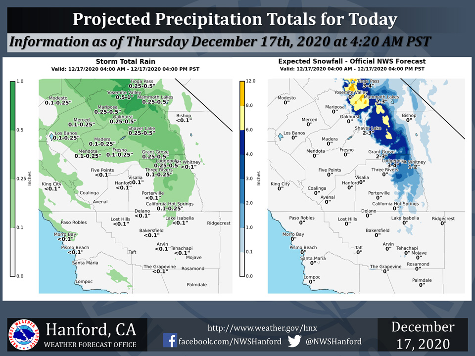
Projected rainfall totals for Mariposa: 0.25" to 0.50"
Projected rainfall totals for Oakhurst: 0.25" to 0.50"
Projected rainfall totals for Yosemite Valley: 0.50" to 1.00"
December 17, 2020 - The National Weather Service Hanford Office reports a storm system will impact Central California Today.
Precipitation amounts will be mostly light, but 6-9 inches of snow is expected to accumulate above 5000 feet across the Central Sierra Nevada.
  Area Forecast Discussion
  National Weather Service Hanford CA
  330 AM PST Thu Dec 17 2020


  .SYNOPSIS...A storm system will bring wet weather to much
  of the district today along with gusty winds in the Kern county
  mountains and desert this afternoon and evening. A clearing trend
  will occur in the wake of this system tonight. A ridge of high
  pressure will build into California by Friday and remain in
  control through the Christmas holiday. Mostly clear skies can be
  expected during this time with areas of late night and morning
  fog in the San Joaquin Valley.

  &&

  .DISCUSSION...
  Regional radar and satellite loops are showing the well advertised
  cold front just entering Merced county as of this writing. The
  front will be passing through CENCAL this morning with some
  possible clearing in the SJV later this afternoon. Unfortunately,
  there is not much lower elevation rain and mountain snow with the
  system. There will be enough to wet the roads, but as you get
  into Kern county, it will be drier. We are expecting winds to pick
  up across the Kern County mountains later today as the front
  pushes through.

  We have a winter weather advisory out for the Yosemite National
  Park area above 5500 feet for snow up to 9 inches through this
  afternoon. Cold air behind the system will allow our temepratures
  to drop below freezing overnight for the next several days into
  early next week. The active storm track will remain well to our
  north as a ridge of high pressure returns and will shun away any
  systems that try to move into CENCAL through the forecast period
  and beyond. We will have a system move through Nevada on Tuesday
  night that could bring some winds across parts of the CENCAL
  interior. A full amplitude ridge will block any weather systems
  along the west coast through the Christmas holiday week. A closed
  low center off of Baja will set up a Rex Block pattern later next
  week. Temperatures will try to moderate some by the end of the
  forecast period with dry conditions expected.
Source: NWS
