


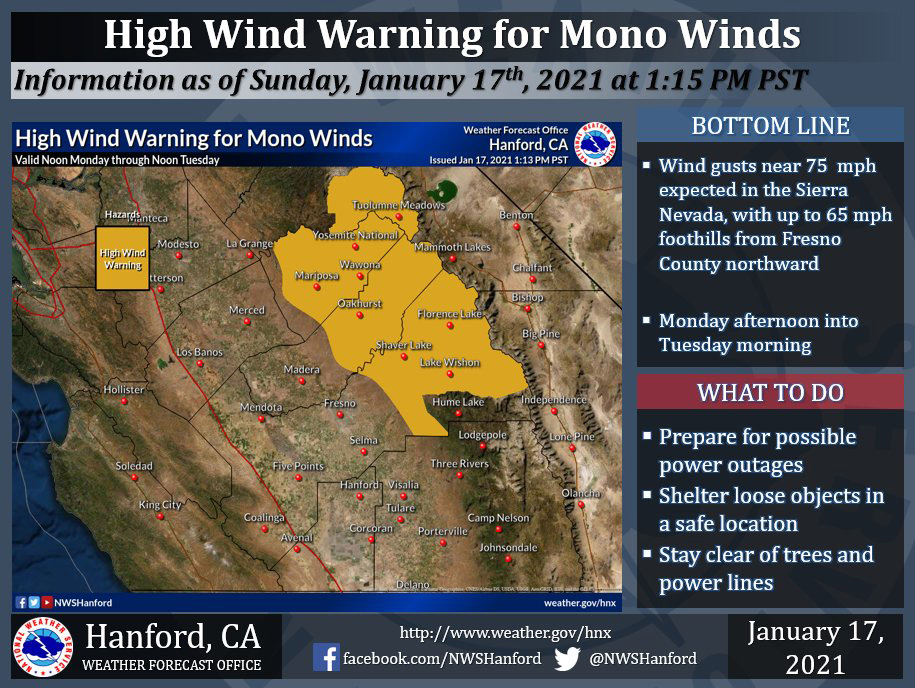
Possible Wind Gusts Near 75 MPH for Portions of Madera and Mariposa Counties (Including Yosemite National Park) and Northern Fresno County
January 17, 2021 - The National Weather Service Hanford Office reportsthe High Wind Watch has been upgraded to a High Wind Warning due to Mono Winds on Monday and Tuesday.
Damaging northeast wind gusts could down a significant number of trees and lead to power outages.
Please plan for intense, damaging winds.
High Wind Warning
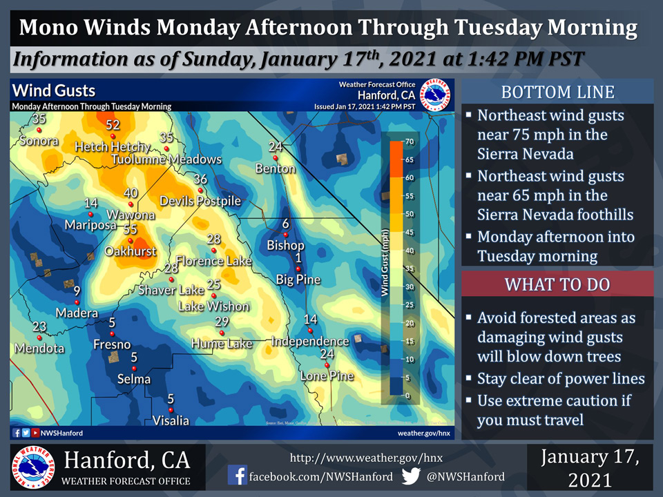
URGENT - WEATHER MESSAGE
National Weather Service Hanford CA
1257 PM PST Sun Jan 17 2021

CAZ190-192-193-180500-
/O.UPG.KHNX.HW.A.0001.210118T2000Z-210119T2000Z/
/O.NEW.KHNX.HW.W.0001.210118T2000Z-210119T2000Z/
Central Sierra Foothills-Central Sierra-North Kings River-
Including the cities of Coarsegold, Oakhurst, Squaw Valley,
Auberry, North Fork, Mariposa, Devils Postpile, Florence Lake,
Lake Thomas Edison, Tuolumne Meadows, Bass Lake, Fish Camp,
Wawona, Lake Wishon, Huntington Lake, and Shaver Lake
1257 PM PST Sun Jan 17 2021

...A HIGH WIND WARNING IS IN EFFECT FROM 12 PM PST MONDAY
AFTERNOON UNTIL 12 PM PST TUESDAY AFTERNOON...

* WHAT...In the Sierra Nevada, sustained northeast winds 30 to 40
  mph, with gusts near 75 mph expected. In the Sierra Nevada
  foothills, sustained northeast winds 25 to 35 mph, with gusts
  near 65 mph anticipated.

* WHERE...Sierra Nevada and adjacent foothills from Fresno County
  northward.

* WHEN...Valid from 12 PM PST Monday afternoon until 12 PM PST
  Tuesday afternoon.

* IMPACTS...Damaging wind gusts will blow down trees and power
  lines. Power outages are expected. Travel will be perilous,
  particularly for high profile vehicles.

* ADDITIONAL DETAILS...Avoid forested areas as damaging wind gusts
  will blow down trees. Stay clear of power lines.

PRECAUTIONARY/PREPAREDNESS ACTIONS...

Secure outdoor items, such as patio furniture, sports equipment,
and trash cans prior to the onset of high winds. Even the most
common objects become dangerous projectiles when picked up and
carried by high winds. Use extreme caution if you must travel.
Source: NWS
