


 launching of 2018 data for the Urban Tree Canopy Viewer Program in California. This program allows communities to understand the extent and location of its existing tree canopy in order to implement sound management practices to optimize community services attained from trees.
The urban tree canopy cover map layer has been updated based on 2018 National Agriculture Imagery Program (NAIP) aerial imagery and LiDAR data collected by the U.S. Geological Survey. With updated data, communities can make more-informed, urban forest management decisions such as prioritizing locations for tree planting, establishing urban forestry master plans, and managing threats to canopy loss.
“Urban trees connect us to nature in our neighborhoods and beyond,” said Regional Forester Randy Moore, USDA Forest Service Pacific Southwest Region. “Conserving California’s healthy forests, including its urban ones, is a shared priority for the Forest Service, CAL FIRE, and many of our partners. We are proud to have worked together to make this tree viewer available to communities across the state that seek to sustain and improve their vital urban forests that serve people in so many beneficial ways.”
The Urban Tree Canopy Viewer provides communities the opportunity to assess benefits and services attained from tree canopy coverage and helps prioritize where those benefits are most needed. Using population and environmental characteristics, this program can help identify communities disproportionately burdened by risks that urban tree cover may help mitigate.
“Trees improve the quality of life in California’s urban environment,” said CAL FIRE Chief Thom Porter. "Not only do they help by absorbing pollutants, cleaning the air, mitigating climate change and reducing heat island effects, but trees make people happy and support their well-being. The Urban Tree Canopy Viewer is a critical tool for local urban foresters to improve management of urban forests, allowing them to target communities that need more trees the most.”
The tree canopy layer was created by EarthDefine, under contract with the Forests Service and CAL FIRE. The layers of population and environmental characteristics were derived from CalEnviroScreen 3.0 from the California State Office of Environmental Health Hazard Assessment, and calculations of the Urban Heat Island Index are from the California Environmental Protection Agency.
SourceL CAL FIRE
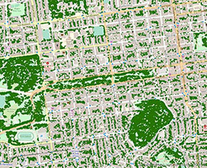
Urban Tree Canopy in California
This interactive viewer shows urban tree canopy in California. Its purpose is to help communities capture community services from trees. A tree’s canopy cover - its leaves, branches, and stems that provide the tree coverage of the ground when viewed from above - is a driving force behind numerous environmental, social, and economic services.
Communities plant trees for numerous reasons. These include reducing summer peak temperatures, improving air quality, reducing stormwater run-off, enhancing property values, providing wildlife habitat, and strengthening social connections in neighborhood. Understanding the extent and location of its existing tree canopy can help a community design and implement sound management practices to maximize those services: prioritizing locations for tree planting, establishing urban forestry master plans and sustainability plans, and managing threats to canopy loss.
The map viewer also highlights population and environmental characteristics that can help identify communities disproportionately burdened by risks that urban tree cover may help ameliorate.
California’s urban tree canopy covers 19% of the state's urban areas. It is estimated to contain 173 million trees; the annual value of ecosystem services from these trees has been estimated at $8.3 billion and the urban forest asset has been valued at $181 billion (McPherson, E., et al 2017).
The tree canopy layer was created by EarthDefine, under contract with the USDA Forest Service and the California Department of Forestry and Fire Protection (CALFIRE). The layers of population and environmental characteristics were derived from CalEnviroScreen 3.0 (Office of Environmental Health Hazard Assessment), and calculations of the Urban Heat Island Index are from the California Environmental Protection Agency.
References Cited
McPherson, E. Gregory; Xiao, Qingfu; van Doorn, Natalie S.; de Goede, John; Bjorkman, Jacquelyn; Hollander, Allan; Boynton, Ryan M.; Quinn, James F.; Thorne, James H. 2017. The structure, function and value of urban forests in California communities. Urban Forestry & Urban Greening. 28: 43-53.
https://doi.org/10.1016/j.ufug.2017.09.013
Source: USFS
