


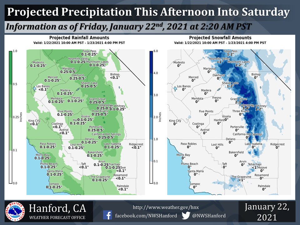
Projected rainfall totals for Mariposa: 0.25" to 0.50"
Projected rainfall totals for Oakhurst: 0.25" to 0.50"
Projected rainfall totals for Yosemite Valley: 0.10" to 0.25"
January 22, 2021 - The National Weather Service Hanford Office reports a storm system will pass through the Golden State this afternoon into Saturday, resulting in precipitation throughout most of Central California.
The majority of this precipitation will fall this afternoon and tonight.
Snow levels could drop as low as 3,000 feet tonight.
An inch or less of snow is conceivable over Kern County mountain passes tonight and Saturday, resulting in the possibility of travel delays.
  Area Forecast Discussion
  National Weather Service Hanford CA
  309 AM PST Fri Jan 22 2021


  .SYNOPSIS...A series of storm systems will bring episodes of rain
  and mountain snow to the central California interior starting
  today. This unsettled pattern will last through at least the
  middle of next week along with significantly cooler temperatures.

  &&

  .DISCUSSION...Water vapor satellite imagery show mid-level and
  high clouds in the southwest flow aloft over Central California,
  ahead of the upper-level low just off the coast of far
  northwestern CA. The associated trough continues to dig southward
  along the Northern CA coast and towards the SF Bay Area. So,
  today`s storm, or the first in the series of at least three storm
  systems, will soon arrive.

  Precipitation chances begin later this morning towards our
  northern portions and by this afternoon to the south, including
  Kern County. This system will bring mainly light precipitation to
  the region, or up to 0.10 to 0.25 inch of precipitation in the San
  Joaquin Valley and Sierra Nevada foothills and around 0.25 to
  0.50 inch in the Sierra Nevada. About 2-4 inches of snow is
  likely in the Sierra above 4,000 feet, although isolated slightly
  higher amounts are possible. Snow levels will be generally around
  4,000 over the mountain areas, though remain a bit higher in Kern
  County until this afternoon. However, by this evening snow is
  possible at the pass levels, including near the Grapevine,
  although it will likely be a dusting and up to 1-2 inches in the
  higher elevations elsewhere in the Kern County mountains. In
  addition, southwest winds may pick up this afternoon in the Kern
  County mountains and desert, with local gusts around 45 mph
  possible. In addition, with the passage of the upper-level trough,
  some rather cold air aloft could provide instability this
  afternoon, so an isolated thunderstorm or two cannot be ruled out.
  Otherwise, cooler temperatures will be in store for today and
  some time to come. Expect mainly seasonal temperatures for today
  and Saturday, with cooler than normal temperatures by early next
  week. A break between systems is expected on Saturday evening
  through Sunday morning.

  The next system will arrive by Sunday afternoon and bring
  precipitation to our forecast area into Monday. Precipitation
  amounts are projected to be a little higher with this second
  system, with 0.20 to 0.40 inch possible in the Central Valley and
  0.50 to 0.75 inch in the Sierra Nevada, although the mountain
  precipitation is expected to be mainly in the form of snow. This
  storm will be quite cold, and snow will likely fall at elevations
  down to around 1,500 feet and possibly a little lower. Just about
  anywhere at and above these elevations could report at least some
  flurries or light snow, so travel may be impacted with possible
  delays. Snow and rain amounts remain a bit uncertain with medium
  confidence at best for this particular system. However, as we get
  closer, winter weather statements may become necessary for areas
  in the Sierra Nevada, adjacent foothills, and Kern County
  mountains. Even some areas in the Kern County desert could observe
  flurries or light snow. On Tuesday, a break in precipitation is
  likely across the region.

  There is the possibility of impactful precipitation on Wednesday
  into Thursday with the next storm, or storm number three. Snow
  levels rise to around 4,000 feet on Wednesday with the potential
  to rise a bit more by Thursday. At this time, the certainty
  remains fairly low (about a 20-30 percent chance, depending on
  location) that we will observe much more than 0.50 to 1.00 inch in
  a 24-hour period during these two days, especially in the San
  Joaquin Valley. There is a better chance that the mountains will
  report even higher amounts of rain, at least below around 5,000
  feet. Total rain accumulations of 1 to 2 inches in the Central
  Valley are possible during Wednesday through Thursday with even
  higher amounts in the lower Sierra Nevada and foothills where
  amounts of 2 to 4 inches are conceivable. Rainfall rates could
  pose challenges in terms of runoff in portions of the burn scars.
  It is more certain that the cool, unsettled pattern will last for
  much of next week. We will monitor for the possibility of roadway
  flooding and debris flows at some of the burn scars with this
  storm. It is going to depend on whether we can tap into
  additional subtropical moisture in terms of snow levels rising
  even further. Confidence regarding timing/track of this storm
  remains low as of now.

  As for next Friday, we could get a brief break from precipitation,
  as the storm finally moves to the south. However, it may be slow
  to move out of our southern portions, or at least Kern County.
  Ensemble guidance in the extended forecast suggests continued
  troughing, or at least a cool pattern and possibly chances for
  more wet weather until the end of the month.
Source: NWS
