


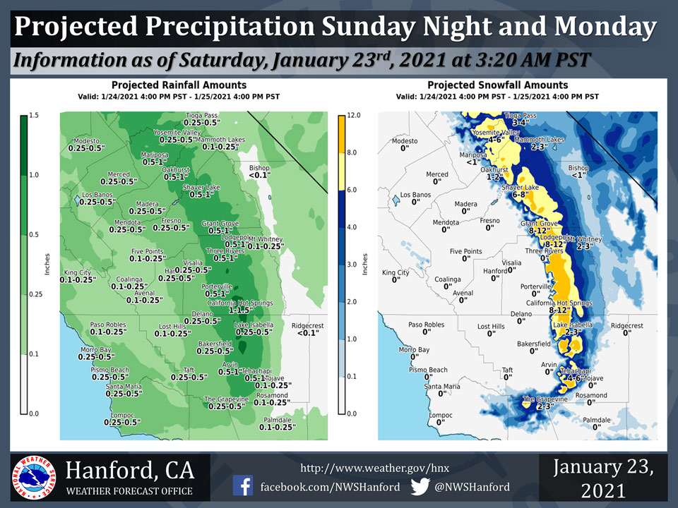
Projected rainfall totals for Mariposa: 0.50" to 1.00"
Projected rainfall totals for Oakhurst: 0.50" to 1.00"
Projected rainfall totals for Yosemite Valley: 0.25" to 0.50"
January 23, 2021 - The National Weather Service Hanford Office reports a storm system will impact Central California Sunday night and Monday, resulting in widespread precipitation.The majority of this precipitation will fall late Sunday night and Monday morning.
Snow levels will drop to as low as 1,500 feet by Monday.
Accumulating snowfall over Kern County mountain passes Sunday night and Monday may cause travel delays and road closures.
  Area Forecast Discussion
  National Weather Service Hanford CA
  243 AM PST Sat Jan 23 2021

  .SYNOPSIS...
  Precipitation will come to an end today as a storm system over
  Central California dives southward into Southern California. A
  trough of low pressure will deepen over California Sunday night.
  This atmospheric disturbance will be responsible for another period
  of wet weather Sunday night and Monday. A major storm system may
  impact Central California Tuesday night through Thursday night.

  &&

  .DISCUSSION...
  An area of low pressure aloft over Central California this morning
  will move southward into Southern California this afternoon.
  Precipitation in the San Joaquin Valley will come to an end this
  morning. Be that as it may, there still could be a few afternoon
  showers. In the Sierra Nevada, Kern County mountains, and Sierra
  Nevada foothills, scattered showers are expected much of the day
  today. An inch or less of snow is likely above 3,500 feet over Kern
  County mountain passes today. Travel delays are possible.

  The next storm system will impact Central California Sunday night
  and Monday. The majority of precipitation associated with this storm
  system will fall late Sunday night and Monday morning. Rain amounts
  of one tenth of an inch to one quarter of an inch are expected in
  the West Side Hills Sunday night and Monday. Rain amounts of one
  quarter of an inch to one half of an inch are anticipated in the San
  Joaquin Valley. The snow level could fall as low as 1,500 feet by
  Monday. Accumulating snowfall over Kern County mountain passes
  Sunday night and Monday may cause travel delays and road closures.
  At this time, we expect about two to four inches of snow to
  accumulate along Tejon Pass and four to six inches of snow to
  accumulate along Tehachapi Pass.

  A major storm system could impact Central California Tuesday night
  through Thursday night. Several feet of snow is possible in the
  Sierra Nevada. Rain amounts of one to two inches in the San Joaquin
  Valley and two to four inches in the Sierra Nevada foothills may
  lead to flooding. The snow level should start at around 2,000 feet
  Tuesday night, before rising to about 4,000 feet by Wednesday
  afternoon.
Source: NWS

