


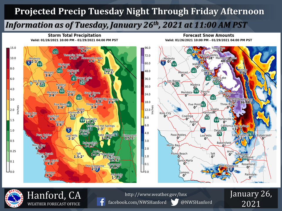
Projected rainfall totals for Mariposa: 6.00" to 8.00"
Projected rainfall totals for Oakhurst: 6.00" to 8.00"
Projected rainfall totals for Yosemite Valley: 8.00" to 10.00"
January 26, 2021 - The National Weather Service Hanford Office reports a major storm system will impact Central California Tuesday night through Friday afternoon, resulting in widespread moderate to heavy precipitation.
The majority of this precipitation will fall Wednesday and Wednesday night.
Snow levels should start as low as 2,500 feet Tuesday night, before rising to around 5,000 feet by Wednesday night.
Hydrologic Outlook
HYDROLOGIC OUTLOOK
National Weather Service HANFORD CA
123 PM PST Tue Jan 26 2021

...SIGNIFICANT RAINFALL EXPECTED DURING THE NEXT FEW DAYS...

A slow moving storm system will bring an abundance of
precipitation into much of the Central California interior
Wednesday through Thursday night. Heavy snow accumulations
are expected in the mountains above 5,000 feet with very
hazardous wintry weather. Rain in the lower elevations
will cause generally minor flooding in areas of the San Joaquin
Valley and lower foothills. However, the potential for more
significant flooding could occur Thursday into Friday if the
storm system were to slow or stall for a time.

Here are projected rain totals by late Friday afternoon and
potential hydrologic impacts by region:

SAN JOAQUIN VALLEY...Rain totals of up to 1.5 inches are likely
in the southeastern part of the San Joaquin Valley with 2 to 4
inches over the remainder of the valley. In addition to slick
road conditions, there will be some ponding of water on roads.
Normally poor drainage areas such as culverts and underpasses
may experienice minor flooding. Additionally, water rises can
be expected along creeks and small streams later this week.

WEST SIDE HILLS...Rain totals of 2 to 4 inches are likely with
local amounts of up to 6 inches. Normally dry arroyos and creeks
could fill with water with some possible overflow and localized
flooding.

SIERRA FOOTHILLS...Although precipitation initally begins as snow
at about the 2,000 foot level, precipitation will generally fall
as rain with storm totals of 3 to 6 inches. Local amounts of up to
8 inches are possible by late Friday afternoon. In addition to
slick driving conditions, there could be some mud and rock slides
with possible road closures. Minor flooding could occur in the
vicinity of small streams due to runoff and water rises. As the
ground becomes saturated, dead, beetle infested trees could
topple in some locations.

MOUNTAINS...Very heavy snow accumulations are likely, especially
above 5,000 feet with hazardous, winter travel and possible road
closures. Strong winds will cause blowing and drifting snow and
local whiteout conditions are likely in the southern Sierra. In
the Kern county mountains, precipitation will initially fall as
snow at about 2500 feet before changing to rain with rain totals
of up to 2 inches likely by late Friday afternoon. Below the snow
level, rain could cause ponding of water on roads with the
possibility of some mud and rock slides.

Residents should stay tuned to NOAA Weather Radio, your favorite
news source and the NWS Hanford`s website, Facebook and Twitter
pages for updates on this major storm.
Source: NWS

