


California and National Drought Summary for January 26, 2021
Summary
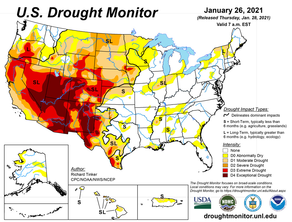
January 28, 2021 - The heaviest precipitation this week fell on a swath across southwestern Kentucky and immediately adjacent locales (3.0 to 4.5 inches), and the higher elevations of Arizona (3.5 to locally over 6 inches). Moderate to heavy amounts of 1.5 to locally 4.0 inches pelted the rest of Kentucky, southern Missouri, northeastern Arkansas, just north of the central Gulf Coast, and patchy areas across southern Virginia and the interior Southeast. Similar amounts dotted southern California and the higher elevations of the southern Sierra Nevada and the Four Corners region, especially across Arizona. Light to moderate precipitation extended across the remainder of the interior Southeast, from central Texas northward through the upper Midwest, across some lower elevations of the Four Corners region, in parts of the southern Great Basin, through most of the Sierra Nevada, and along much of the immediate West Coast. Much of the precipitation fell as heavy snow late in the period from Kansas and Nebraska to the lower Great Lakes. Amounts topped one foot at scattered spots across southwestern Iowa and southeastern Nebraska, with Omaha, NE reporting just under a foot. Small areas of moderate precipitation were observed in some areas to the lee of Lakes Erie and Ontario, but otherwise, the driest areas this week – reporting little or no precipitation – stretched along the northern tier of states from the Cascades through New England, most of the Intermountain West, the High Plains, southern Texas, Florida, the southern Atlantic Coast, the northern Ohio Valley, and the middle Atlantic States. No large, broad-scale changes were appropriate as a result, but numerous smaller-scale adjustments were introduced.
Northeast
A small area of heavy precipitation eliminated D0 conditions on the lee side of eastern Lake Ontario, and the recent persistence of subnormal precipitation prompted expansion of moderate drought into northeastern Vermont. Otherwise, areas of relatively long-term abnormal dryness and moderate drought were unchanged.
Southeast
Southern Virginia and much of Alabama experienced a fairly wet week, with lesser precipitation amounts across the Carolinas, Georgia, and Florida. After several weeks of monitoring, D0 was brought into extreme southwestern North Carolina and adjacent areas, and the patches of dryness to the south were adjusted in response to observed precipitation. Increasing 60-day moisture deficits prompted expansion of abnormal dryness into northeast Florida, and small adjustments were made to the areas of relatively short-term dryness to the north, in response to weekly rainfall totals and changing 60- to 90-day precipitation deficits. The small area of moderate drought in south-central Alabama was unchanged in response to 0.5 to 1.5 inches of rain.
South
Moderate to heavy precipitation fell on swaths of Tennessee and the lower Mississippi Valley, bringing improvements to some of those regions. But the precipitation was not widespread, and some parts of this area that missed the heavier precipitation saw an increase in dryness and drought. Farther east, heavier precipitation was more sparsely distributed through Oklahoma, northeastern Texas, and central Texas, with the remainder of Texas recording only light amounts. Besides adjustments to short-term cry areas in response to the rainfall pattern, moderate drought persisted in southwestern Tennessee, and expanded into larger sections of northwestern Mississippi and south-central Louisiana. In addition, an area of severe drought was assessed in an area centered near Tallahatchie County, MS where 90-day rainfall totals were 8 to 10 inches below normal and 6-month totals were 10 to 12 inches below normal. In the expanded area of moderate drought in southern Louisiana, 6-month rainfall totals were as much as 15 inches below normal, but shorter-term deficits are less remarkable.
Midwest
Heavy precipitation fell on most of Kentucky and southern Missouri, with amounts dropping off farther north. Moderate amounts of precipitation – mostly areas of heavy snow – stretched across Iowa into the southwestern Great Lakes region. Elsewhere, precipitation was light at best. Predictably, the abnormal dryness introduced across Kentucky last week was removed in response to the heavy precipitation this week. Conditions also led to smaller areas of improvement in Iowa and parts of Missouri. In contrast, a dry week led to some southward expansion of dryness and moderate drought in central Illinois and Indiana. Farther north, moisture deficits have been slowly increasing across much of Wisconsin and Michigan. A swath from central Wisconsin through the Michigan Upper Peninsula and northern Lower Peninsula have received less than half of normal precipitation in the last 2 months. The cold climate this time of year has kept expansion and intensification of the dry conditions from western Wisconsin at bay, but the region will continue to be monitored, especially as we head toward a milder time of year.
High Plains
Moderate precipitation and/or heavy snow hit eastern Nebraska and Kansas, and isolated but heavy precipitation fell on some of the higher elevations of Colorado. Other areas received light amounts at best. Decent snowpack and recent heavy precipitation in the highest mountains led to some improvement in the protracted D2-D4 in a few ranges in north-central and south-central Colorado. Areas farther north experienced another dry week, resulting primarily in a fairly broad expansion of severe drought into northeastern Wyoming and the western Dakotas.
West
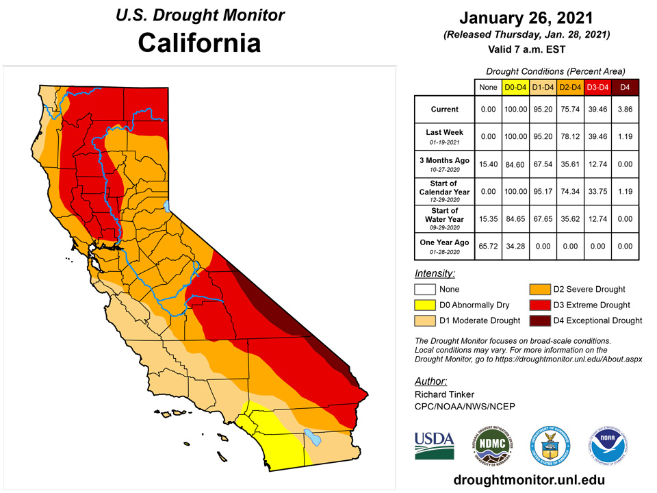
Persistent above-normal precipitation led to improvements across the southern tier of the region as well as the southern Oregon coast. At the same time, continued deficient precipitation led to significant expansion and/or deterioration of D3 and D4 conditions near the Nevada/California border, and D0 to D2 conditions across Montana and adjacent Wyoming. Notably, the protracted D4 conditions in central Arizona finally eased slightly as the higher elevations report above-normal precipitation and a favorably enhanced snowpack. Smaller areas of improvement due to recent increased precipitation were brought into north-central New Mexico, southwestern Arizona, and southeastern California.
Alaska, Hawaii, and Puerto Rico
Rainfall was unremarkable across Puerto Rico. Totals of 0.5 to 1.5 inches were scattered across the Commonwealth, especially along the northern tier. Light rain at best was noted from San Sebastian to the northwestern coast and along the southern tier from southern Yauco to Patillas. Moisture was sparsest through Salinas, Coamo, and Ablonito. However, D0 remained across northern parts of Island, expanding slightly westward and substantially eastward to cover areas from Isabela and Lares eastward through Rio Grande and adjacent areas. Moisture deficits are most acute on the 30- to 90-day time scales from eastern Camuy eastward through Vega Baha and down through northern Ciales.
Heavy precipitation across central Hawaii led to a broad area of improvement across southeast Oahu, Molokai, Lanai, Kahoolawe, and Maui. Lesser amounts kept conditions unchanged across the Big Island and from central and western Oahu through Kauai.
Patches of abnormal dryness remained unchanged in a few swaths across northern and eastern Alaska.
Pacific Islands
The weather across the U.S.-Affiliated Pacific Islands (USAPI) during this USDM week (01/20/20-01/26/21) was dominated early in the week by an Inter-Tropical Convergence Zone (ITCZ) across central to eastern Micronesia, a near-equatorial surface trough with convergent flow across Palau and southwestern Yap State, and trade-wind disturbances scattered about elsewhere. As the week ended, the ITCZ dissipated, to be replaced by a seasonally dry trade-wind flow over northern portions of the Federated States of Micronesia (FSM) and the Marshall Islands (RMI) with small weaker surface troughs. A cold front or shear line moved across the Marianas, bringing limited showers, but otherwise a dry season trade-wind flow dominated the weather. South of the equator, a dry surface ridge dominated the weather over the Samoan Islands for much of the week, with the South Pacific Convergence Zone (SPCZ) staying to the south. The week ended with the SPCZ moving north, bringing heavy rain and Flash Flood Warnings to American Samoa.
Satellite-based estimates of 7-day precipitation (QPE) showed a large continuous band of precipitation associated with the SPCZ extending from north of Australia southeastward to south of the Samoan Islands, and another smaller discontinuous band of precipitation extending westward from Indonesia across Micronesia. A large area of 2+ inches of rainfall (the SPCZ) was indicated on the QPE west and south of the Samoan Islands, with fingers of 1+ inches extending across the Samoan Islands. A broken band of 1+ inches of rainfall stretched across southern portions of the Republic of Palau, the FSM, and RMI. The band extended from roughly 2 degrees North latitude to 9 N over parts of Yap State, but narrowed to roughly 2 N to 5 N over Kosrae State and the RMI. Half an inch of precipitation was indicated on the QPE over Guam, but otherwise little to no rainfall was reflected on this satellite tool over the Marianas or northern portions of the FSM and RMI.
Wet conditions continued at American Samoa this week. Pago Pago received 6.81 inches of rain, Toa Ridge received 4.83 inches, and Suifaga Ridge received 3.85 inches. Therefore, drought-free conditions continued another week.
Only 1.70 and 0.63 inches of rain fell at Palau and the Koror COOP station this week, respectively, but given sufficient rainfall in mid-January and in December, conditions remained free of drought for another week.
All three stations on Saipan this week came in under 1 inch of rain, so short-term abnormal dryness continued there. A wildfire was reported on Wireless Ridge there last week, indicative of the dry conditions. Station reports indicated that Guam received 2.13 inches of rain this week, which snapped a streak of 5 consecutive weeks below their weekly minimum rainfall, and drought-free conditions continued. On Rota, 0.87 inches of rain fell this week, marking the fifth of the last 6 weeks to fall below an inch of rain. However, over 4 inches of rain in the last full week of December is keeping abnormally dry conditions at bay.
Yap only received a reported 0.10 inches of rain this week (though 2 days were unaccounted for). However, 4.50 inches of rain fell last week, so conditions there remain free of drought. On Ulithi, only 0.36 inches of rain fell this week, snapping a streak of wet weeks there; drought-free conditions continued for another week. On Woleai, normal conditions continued after 2.01 inches of rain fell, snapping a 3-week period with less than 2 inches of rain. Another dry week took place on Fananu, with 0.27 inches of rain, about the same as last week. However, 4.88 inches of rain fell 2 weeks ago, and 10.17 inches fell in the last full week of 2020, so conditions are still normal there. On Chuuk, only 1.24 inches of rain fell this week, but the previous 4 weeks were quite wet, and drought-free conditions continued. On Lukunor, the first relatively dry week since mid-November occurred, with only 0.11 inches of rain accumulating. January has already exceeded the monthly minimum amount, with 12.11 inches having accumulated. After 3 consecutive weeks with over 6 inches of rain, 2.02 inches fell this week on Nukuoro, continuing the wet conditions there. On Nukuoro, 21.62 inches of rain have already accumulated in January, placing this month’s rainfall at the 87th percentile with several days still to go in January. A relatively dry week took place on Kapingamarangi, with only 0.79 inches, but combined with 2.45 inches last week, conditions have improved enough in the short term to improve Kapingamarangi to extreme short- and long-term drought from the previous exceptional drought. This week was relatively dry on Pohnpei, with only 0.97 inches of rain, ending what had been a very wet period previously; drought-free conditions continued there. On Pingelap, 0.49 inches of rain this week marked the second week in a row with less than 2 inches of rain. However, January’s rainfall is already at 14.92 inches, near the 77th percentile, and drought-free conditions continued. January rainfall on Kosrae has reached 29.34 inches, which is at the 94th percentile, though this week only contributed 0.78 inches of that.
A paltry 0.03 inches of rain fell this week on Kwajalein, where conditions degraded to short-term moderate drought, as this was the 8th consecutive week below 2 inches of rain there. Dry conditions continued on Wotje, where no rain fell this week after only 0.95 inches fell last week. Given a 5-week stretch of no rainfall from December 15 to January 12, and another dry week this week, conditions there have worsened to short-term moderate drought. On Ailinglapalap, only 0.78 inches of rain fell this week, but most previous weeks reached at least 2 inches, so normal conditions continued there. No rain had been reported on Jaluit this week as of the time of writing, marking the second consecutive week with less than an inch of rain, but normal conditions continued there, as December’s rainfall exceeded 15 inches. No rain had been reported on Majuro as of the time of writing, but every week there since mid-November 2020 saw at least 2 inches of rain accumulate, so drought-free conditions continued. Only 0.55 inches of rain fell on Mili this week, but with 4.27 inches of rain last week, conditions there have not significantly dried.
Virgin Islands
Short- and long-term abnormal dryness continued for another week on St. Croix, where precipitation statistics out to 12 months continued to support the abnormally dry depiction. Conditions on St. Thomas and St. John both degraded to short-term moderate drought, due to very dry conditions over the last month, warm temperatures, and impacts on vegetation. Groundwater levels on all three islands continued to drop this week.
Looking Ahead
Over the next 5 days (January 28 – February 1, 2021) the heaviest precipitation is expected along the immediate West Coast, southern Cascades, and Sierra Nevada. These areas are expecting 3 to locally 7 inches of precipitation. Meanwhile, 1 to 3 inches are expected in the central and northern Cascades and the higher elevations from northeastern Oregon to northwestern Wyoming. Up to 2 inches may fall on north-central Utah, the higher elevations of Arizona, and part of Nevada. Farther east, the western half of the Plains should be dry, and only light precipitation is forecast across the northern Great Lakes, lower Mississippi Valley, Gulf Coast, Florida, and upper New England. Moderate to locally heavy precipitation should fall on a swath from much of the Mississippi Valley eastward through the southern half of the Appalachians, middle Atlantic region, and upper Southeast. The eastern half of North Carolina should pick up 1 to 2 inches. In the portions of the Plains expecting very little if any precipitation, daytime temperatures should average at least 3 degrees F above normal, with a swath from the Texas Panhandle to eastern Montana averaging 6 to 12 degrees F warmer than normal. In contrast, most of the Pacific and Atlantic Coasts and the Southwest should average at least 3 degrees F below normal. Daytime high temperatures will average at least 6 degrees F below normal in central Arizona, northern California, the upper Northeast, and lower New England.
The ensuing 5 days (February 2 – 6, 2021) bring enhanced chances of surplus precipitation in a broad area from the Rockies to the East Coast, excluding much of Texas and Florida. Odds favor above-normal precipitation throughout Alaska as well. Meanwhile, deficient precipitation is more likely across the Florida Panhandle, the southern one-third of Texas, northern California, and the Pacific Northwest. Warmer than normal weather is favored east of the Mississippi Valley and north of Florida, with the highest probabilities covering New England. Milder than usual conditions are also expected in the southern half of Alaska. Meanwhile, the odds favor subnormal temperatures from the High Plains to the West Coast, especially across California and most of Nevada, Utah, and Arizona.
Author(s):
Richard Tinker, NOAA/NWS/NCEP/CPC
Curtis Riganti, National Drought Mitigation Center
Dryness Categories
D0 Abnormally Dry—used for areas showing dryness but not yet in drought, or for areas recovering from drought.
Drought Intensity Categories
D1 Moderate Drought
D2 Severe Drought
D3 Extreme Drought
D4 Exceptional Drought
Drought or Dryness Types
S Short-Term, typically less than 6 months (e.g. agricultural, grasslands)
L Long-Term, typically greater than 6 months (e.g. hydrologic, ecologic)
Source: National Drought Mitigation Center

