


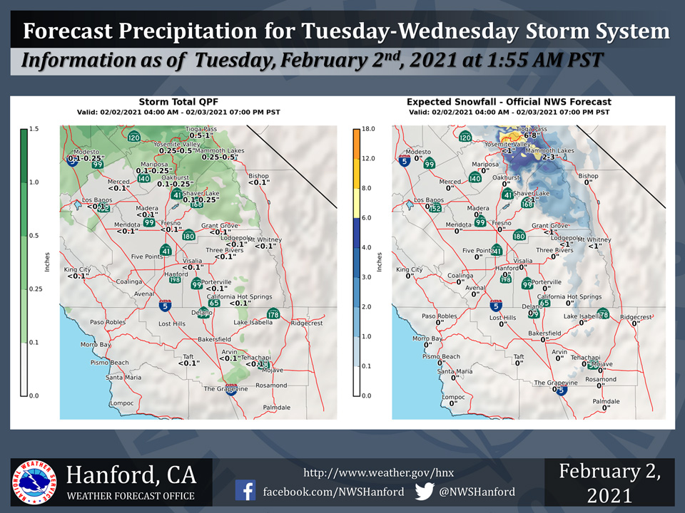
Projected rainfall totals for Mariposa: 0.10" to 0.25"
Projected rainfall totals for Oakhurst: 0.10" to 0.25"
Projected rainfall totals for Yosemite Valley: 0.25" to 0.50"
February 2, 2021 - The National Weather Service Hanford Office reports another storm system will bring rain and mountain snow to parts of the Central California Interior today through Wednesday afternoon.Snow will mostly fall above 5,500 feet.
Here are the latest projected rain and snowfall amounts.
  Area Forecast Discussion
  National Weather Service Hanford CA
  348 AM PST Tue Feb 2 2021

  .SYNOPSIS...
  Cold front will swing through the region overnight tonight
  bringing a few light rain showers north of Fresno county. Light
  snow mainly over Yosemite this afternoon will increase overnight.
  Clearing on Wednesday evening with dry conditions into early next
  week. A gradual warming trend is also expected.

  &&

  .DISCUSSION...
  After record warmth across several locations most of the CENCAL
  interior yesterday, we are forecasting a frontal band to move
  through the region later today and tonight. Light precip is
  possible in Merced and is forecast to remain confined mainly
  north of Fresno County. Models have backed off the timing and
  intensity of forecast precip with this event.

  We have cancelled the winter weather advisory for Kings Canyon
  National park as well as Sierra National Forrest. Model output
  for snow is not meeting the required 6 inches for 24 hours
  advisory criteria. The NAM is washing out the front across the
  valley and focusing on upslope dynamics overnight for period of
  moderate snow. We have trimmed the QPF back to near 0 across the
  SJV south of Fresno county. The front is slow to move through and
  will keep clouds across the region tonight and most of tomorrow
  before moving east of the region.

  We are expecting clouds to build up along the foothills and
  especially the south valley on Wed as the front pushes through. We
  are not expecting much in the way of wind in Kern county, as this
  system does not have much energy with it. We could see some
  drizzle in the south valley due to upslope clouds. The models are
  generating some QPF in the south valley, eventhough the amounts
  are light.

  A secondary trough will follow right behind the front on Thursday
  bringing in some freezing temperatures across the SJV on Friday
  and Saturday mornings with plenty of frost around. A gradual
  warming trend is in store for the weekend as mid level ridging
  will allow for temperatures to increase over the weekend with
  continued dry conditions into early next week.
Source: NWS
