


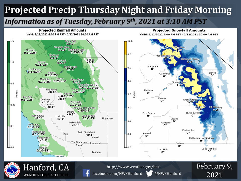
Projected rainfall totals for Mariposa: 0.50" to 1.00"
Projected rainfall totals for Oakhurst: 0.50" to 1.00"
Projected rainfall totals for Yosemite Valley: 1.00" to 1.50"
February 9, 2021 - The National Weather Service Hanford office reports a trough of low pressure will move southeastward across Northern California Thursday night into Friday morning.
In the San Joaquin Valley, rain amounts will be lowest in Kern and Kings Counties.
Snow levels will start at around 7,000 feet Thursday night, before falling to about 5,000 feet Friday morning.
  Area Forecast Discussion
  National Weather Service Hanford CA
  400 AM PST Tue Feb 9 2021


  .SYNOPSIS...A weak cold front will move southward through
  the central California interior today with little more
  than sprinkles in the valley and foothills and isolated
  showers in the Sierra north of Kings Canyon. Otherwise,
  dry weather will prevail over the district through Thursday.
  A couple of storm systems will move through the region from
  Thursday evening through Sunday with rain and mountain snow.
  Temperatures will average slightly above normal through
  Thursday before trending much cooler at the end of the week.

  &&

  .DISCUSSION...Wet weather is definitely in the offing later
  this week and it couldn`t be more welcome. After all, it`s
  been at least ten days since any precipitation has fallen
  anywhere over the central California interior. The storm
  systems that will bring water into the CWA in the 3 to 7 day
  period aren`t likely to rival the heavy deluge we received
  during the last week of January. Nonetheless, by Presidents
  day, the mountains above 7,000 feet will be blanketed by
  several new inches of snow, a soaking rain will fall in the
  foothills and the eastern third of the San Joaquin Valley
  should receive its first wetting rain this month.

  In the meantime, a rather weak and diffuse Pacific cold front
  will drag its feet through the central California interior
  this afternoon. This front will be the "door opener" for storm
  systems later in the week. Its passage through the CWA today
  will be accompanied by little more than sprinkles in the valley
  and foothills. Isolated showers or snow flurries are possible
  with this front in the Sierra north of Kings Canyon today and
  it will be nothing to write home about. In the wake of this
  cold front, westerly winds will increase through and below the
  Kern county mountain passes by late this afternoon and remain
  gusty into Wednesday. Additionally, some low clouds may bank
  up along the west slopes of the Sierra and the north facing
  slopes of the Tehachapi mountains tonight and linger into
  Wednesday morning.

  A high pressure ridge over the Eastern Pacific will build into
  central California Wednesday and remain in control through at
  midday Thursday with dry weather. Increasing and thickening
  clouds Thursday will be the forerunners of precipitation that
  will probably arrive over the northern part of our CWA as
  early as Thursday afternoon. Kern County will have to wait
  until at least Thursday evening for the arrival of wet weather.
  The models differ slightly on the exact track of the upper level
  low associated with this late week storm system but seem to
  agree that it will exit south and east of our CWA by Friday
  afternoon, during which time the precipitation it brings will
  be ending or have already ended.

  Another ridge of high pressure is forecast to build in behind
  Friday`s departing storm and remain in control Friday night
  into Saturday. The storm system that follows will be colder
  and wetter and will bring rain and mountain snow to the district
  from midday Saturday into Sunday.  There are timing differences
  with the models.(The ECM is about 6 hours slower than the GFS.)
  Whatever the case, this second round of precipitation should
  wrap up by Sunday afternoon as an Eastern Pacific ridge begins to
  build into the Golden State.

  A northwesterly flow aloft will reside over California early
  next week. While this is generally a dry pattern for us, weak
  upper level disturbances embedded in this flow could generate
  light precipitation at times in the Sierra on days 6 and 7.
  Temperature-wise, we`ll be trending a bit cooler each day this
  week but still remain slightly above normal until the end of
  this week.
Source: NWS
