


California and National Drought Summary for February 9, 2021
Summary
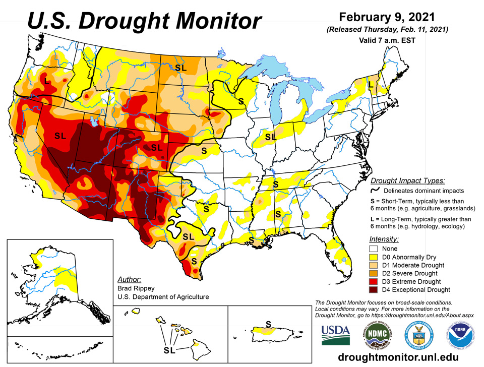
February 11, 2021 - A slow-moving coastal storm delivered heavy precipitation in parts of the Northeast on January 31 – February 1, with impacts (windy weather and snow showers) lingering for several days. Later, the focus for stormy weather briefly returned to the western U.S., although significant precipitation was confined to the northern Rockies and Pacific Northwest. By February 4, wintry weather shifted into the upper Midwest, where blowing snow and gusty winds briefly resulted in blizzard conditions. The same weather system produced generally light rain across the South. Later, additional patchy precipitation fell in the central and eastern U.S., although dry weather prevailed during the drought-monitoring period across much of the nation’s southwestern quadrant. At the height of the early-February cold outbreak, temperatures plunged below -20°F across portions of the northern Plains and upper Midwest. Sub-zero readings occurred across a much larger area, extending southward across the central Plains and into the middle Mississippi Valley.
Northeast
In early February, heavy Northeastern snow mostly bypassed existing areas of abnormal dryness (D0) and moderate drought (D1). There was enough snow, however, to reduce the coverage of D1 in northern New York. Outside the areas of Northeastern dryness and drought, storm-total snowfall from January 31 – February 3 reached 27.3 inches in Allentown, Pennsylvania; 18.2 inches in Newark, New Jersey; 17.4 inches in New York’s Central Park; and 12.1 inches in Hartford, Connecticut.
Southeast
Periodic showers were heaviest across the lower Southeast, including parts of northern Florida. Where the most significant rain fell, there were reductions in the coverage of abnormal dryness (D0). On February 6 in Florida, daily-record rainfall totals included 2.13 inches at Jacksonville’s Craig Airport and 1.85 inches in Gainesville. Craig Airport received 2.99 inches in a 24-hour period on February 6-7. A few days earlier, one of Florida’s coldest outbreaks in several years had resulted in light freezes as far south as the Lake Okeechobee area. On February 4, daily-record lows in Florida dipped to 29°F in Fort Pierce and 30°F in Vero Beach. In both cities, temperatures had remained above 32°F on 1,112 consecutive days, from January 19, 2018 – February 3, 2021. Farther west, only light showers dampened Alabama and westernmost Florida, where there were modest increases in the coverage of dryness and moderate drought (D1).
South
Despite a few showers, the general trend toward drier conditions continued, with some increasing coverage of abnormal dryness (D0) and moderate drought (D1) in Arkansas, Louisiana, Mississippi, and Tennessee. During the first 40 days of the year (January 1 – February 9), precipitation ranged from one-third to one-half of normal in locations such as Crossville, Tennessee (3.02 inches, or 49% of normal); Meridian, Mississippi (3.24 inches, or 46%); Lake Charles, Louisiana (2.86 inches, or 45%); Greenville, Mississippi (2.95 inches, or 43%); Jackson, Tennessee (2.25 inches, or 41%); New Iberia, Louisiana (2.57 inches, or 40%); Lafayette, Louisiana (2.78 inches, or 39%); Monroe, Louisiana (2.43 inches, or 38%); Vicksburg, Mississippi (2.37 inches, or 36%); and New Orleans, Louisiana (2.39 inches, or 35%). Short-term dryness also extended westward to coastal Texas, where some D1 was introduced between Port O’Connor and Galveston. During the first 40 days of the year, rainfall in Galveston totaled just 0.81 inch (16% of normal). Meanwhile, persistent warmth accompanied dry weather in southern Texas, resulting in growing coverage of moderate to extreme drought (D1 to D3). Drought deterioration was also noted on the High Plains, particularly in northern Texas and portions of neighboring states. According to the U.S. Department of Agriculture, statewide topsoil moisture in Texas was rated 55% very short to short on February 7, although agricultural district values were as high as 96% on the Northern High Plains (Amarillo area), 90% in the Lower Valley (Brownsville area), and 84% on the Southern High Plains (Lubbock area). In addition, 53% of Texas’ rangeland and pastures were rated in very poor to poor condition on that date, along with 31% of the winter wheat.
Midwest
The region’s biggest storm of the drought-monitoring period struck on February 4-5, featuring wind-driven snow across the upper Midwest. February 4 snowfall totals greater than 5 inches were accompanied by peak wind gusts to 40 mph or higher in locations such as La Crosse, Wisconsin (5.8 inches and 40 mph), and Dubuque, Iowa (5.2 inches and 44 mph). In Wisconsin, daily-record snowfall amounts for February 4 reached 10.4 inches in Rhinelander and 8.0 inches in Antigo. A small amount of abnormal dryness (D0) was trimmed form the upper Great Lakes region. Elsewhere, the area of dryness (D0) and moderate drought (D1) stretching from the middle Mississippi Valley into the lower Great Lakes region was reduced in size on the western side but exhibited a small increase in coverage in eastern Indiana and western Ohio. As the drought-monitoring period progressed, bitterly cold air invaded the Midwest. Daily-record lows included -34°F (on February 8) in Hibbing, Minnesota, and -33°F (on February 9) in Merrill, Wisconsin.
High Plains
: Overall, there were few changes to the High Plains’ drought depiction. Frigid weather settled across the region in early February, accompanied by periods of snow mainly in Nebraska and upslope (western) regions. Mostly dry weather persisted, however, in several areas, including northeastern Montana and the Dakotas, where lack of snow cover remained a concern with respect to lack of insulation for winter wheat during the protracted spell of sub-zero temperatures. In Glasgow, Montana, snow cover totaled an inch or less each day during the cold blast, which began with a low of 0°F on February 4 and included at least four consecutive readings below -20°F from February 7-10. In contrast, parts of Nebraska remained beneath a blanket of snow, some of which had fallen during a major storm on January 25. However, some additional snow fell in Nebraska and environs during the drought-monitoring period. For example, the weekend of February 6-7 featured Nebraska snowfall totals of 11.6 inches in North Platte, 9.6 inches in Lincoln, and 9.3 inches in Grand Island.
West
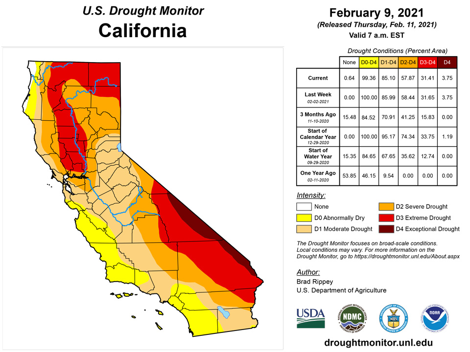
Aside from widespread precipitation in the Pacific Northwest and northern Rockies, the western U.S. experienced a much more tranquil drought-monitoring period. In fact, little or no precipitation fell across southern California, the Great Basin, and the Southwest, although mostly status-quo drought coverage was noted in the wake of late-January storminess. Farther north, coverage of severe to extreme drought (D2 to D3) was reduced in parts of southeastern Montana and northeastern Wyoming. Meanwhile, Oregon’s changes were mixed, with some general deterioration of conditions in the northeast and further improvement west of the Cascades. Following the late-January storminess, the California Department of Water Resources indicated that the average water equivalency of the high-elevation Sierra Nevada snowpack stood at nearly 13 inches (65% of normal for February 10), well above the January 24 value of 6 inches.
Alaska, Hawaii, and Puerto Rico
Cold weather prevailed in Alaska, with lingering mild conditions mostly limited to the state’s western tier. The temperature in Fairbanks remained continuously below 0°F from January 30 – February 9, with the streak ongoing. However, Fairbanks also received 5.3 inches of snow from February 3-6. Unusually cold weather even reached into southeastern Alaska, where Ketchikan notched a daily-record low of 6°F on February 9. Given unusually low snowpack in east-central Alaska, abnormal dryness (D0) was extended to the Canadian border. Meanwhile, a review of winter precipitation allowed for some trimming of the southern edge of the D0 area in northwestern Alaska. Farther south, further assessment of late-January precipitation that fell on Hawaii’s Big Island led to the removal of abnormally dry conditions from near South Point and a reduction of D0 coverage on the slopes of Mauna Kea. Elsewhere, there has been a gradual westward shift of Puerto Rico’s area of D0 and D1, with that trend continuing in the latest analysis.
Pacific Islands
Satellite-based estimates of 7-day precipitation (QPE) showed rainfall of 3 to 6 inches over the Republic of Palau, while to the northeast, the Mariana Islands received very little. The Federated States of Micronesia received up to roughly 3 inches, with amounts increasing to the south. The Republic of the Marshall Islands received up to 2 inches, but coverage was spotty. American Samoa ranged from half an inch, upwards to 3 or more inches.
The Republic of Palau remained free of drought. Palau IAP received 4.27 inches for the week, while Koror COOP reported 2.77 inches, both exceeding the weekly minimum of 2 inches to meet water needs.
The Mariana Islands remained dry with abnormal dryness affecting Rota and Saipan. Guam received 0.72 inches and Rota received just 0.50 inches, although the Mariana Islands require an inch per week to meet minimum water needs. The Saipan IAP received 1.25 inches, while the ASOS and NPS measured 0.71 and 0.51 inches, respectively. In recent weeks, there were reports of several grass fires across Guam and Saipan.
Precipitation amounts for the Federal States of Micronesia varied greatly with Chuuk, Fananu, Kapingamarangi, Pohnpei, and Ulithi receiving less than an inch, falling below the 2 inches needed to meet minimum water needs for a week. Kosrae, Nukuoro and Woleai received 4.5 to nearly 8 inches of rain. Abnormal dryness was introduced for Fananu as rainfall was a third of an inch or less in recent weeks, while Kapingamarangi remained in extreme drought as rainfall was just 0.18 inches for the week. Vegetation on Kapingamarangi has turned much greener, but was still recovering from meager rainfall since the end of July 2020, and breadfruit, a major staple food, continued to fall from trees prematurely. Pohnpei reported 0.56 inches for the third week of less than half of normal rain, although January rainfall totaled 18.83 inches.
The Marshall Islands were very dry for the past seven days. All locations received less than a half inch of rain, prompting the introduction of abnormal dryness to Jaluit, where just 0.27 inches fell on the heels of a dry January when rainfall amounted to 5.26 inches, which is 54.1% of normal. Kwajalein and Wotje both entered moderate drought, following poor rainfall in December and January. Dry conditions were reported across the atolls and islets on Kwajalein atoll, where at least one atoll was rationing water. Majuro received only 0.02 inches as reservoirs declined from 28.00 million gallons on Feb. 2 to 27.67 million gallons on Feb. 4. Ailinglaplap has seen low rainfall for three consecutive weeks.
American Samoa remained free of drought as rain was plentiful. Pago Pago received 7.25 inches, while Siufaga Ridge and Toa Ridge reported 5.94 and 6.14 inches, respectively.
Virgin Islands
The U.S. Virgin Islands remained dry and warm for the past week, with St. Thomas and St. John in moderate drought, and St. Croix abnormally dry. Radar-based estimates of rainfall for the 7 days ending at 12z on Tuesday indicated that St. Thomas received from 0.50 inches to more than 1.5 inches, while St. John’s precipitation ranged from half an inch or more on the west end of the island to as little as 0.10 in the east. St. Croix was very dry, receiving less than a tenth of an inch on the western half of the island as the eastern half stayed dry.
Precipitation at St. Thomas’s CoCoRaHS stations varied from 0.28 to 1.53 inches for the past week. The SPI values at 3, 6, 9, and 12 months for the Cyril E King Airport indicated abnormal dryness at 3, 9, and 12 months, and drought-free conditions at 6 months. St. Thomas remained in moderate drought.
St. John’s Windswept Beach CoCoRaHS station reported 0.19 inches, while other stations reported from 0.05 inches to 0.19 inches. The SPI values for 1, 3, 6, 9, and 12 months for Windswept Beach indicated moderate drought at 1 and 3 months, drought-free conditions at 6 and 9 months, and abnormal dryness at 12 months. St. John remained in moderate drought.
St. Croix remained abnormally dry this week. Precipitation at Henry Rohlsen AP amounted to 0.08 inches. Three CoCoRaHS stations reported precipitation, receiving from 0.04 to 0.12 inches. The SPI values for 1, 3, 6, 9, and 12 months for Henry Rohlsen AP indicated drought-free conditions at one month, moderate drought at 3 months, and abnormal dryness at 6, 9 and 12 months.
Looking Ahead
During the next several days, multiple storm systems will travel along or near a boundary separating warm air across the Deep South from frigid conditions farther north. Where storm-related moisture overruns cold air, there will be a significant threat of wintry weather (e.g. snow, sleet, and freezing rain), leading to potential travel disruptions and power outages. The parade of storms will produce generally light snow across the central Plains, Midwest, and Northeast, with periods of wintry precipitation expected from the southern Plains to the mid-Atlantic. Five-day Southeastern rainfall totals could reach 1 to 3 inches or more, except across the southern tip of Florida. Much of the West will also experience multiple rounds of precipitation. Each passing storm system will help to draw cold air farther southward, leading to sub-zero weekend temperatures possibly as far south as northern Texas.
The NWS 6- to 10-day outlook for February 16 – 20 calls for the likelihood of colder-than-normal conditions nationwide, except for near-normal temperatures in southern California and above-normal temperatures along the southern Atlantic Coast. Meanwhile, near- or above-normal precipitation will occur in most areas of country, with drier-than-normal weather limited to southern California, the Desert Southwest, and the north-central U.S.
Author(s):
Brad Rippey, U.S. Department of Agriculture
Denise Gutzmer, National Drought Mitigation Center
Dryness Categories
D0 Abnormally Dry—used for areas showing dryness but not yet in drought, or for areas recovering from drought.
Drought Intensity Categories
D1 Moderate Drought
D2 Severe Drought
D3 Extreme Drought
D4 Exceptional Drought
Drought or Dryness Types
S Short-Term, typically less than 6 months (e.g. agricultural, grasslands)
L Long-Term, typically greater than 6 months (e.g. hydrologic, ecologic)
Source: National Drought Mitigation Center

