


Related: NASA Invites Public to Share Thrill of Mars Perseverance Rover Landing on Thursday, February 18th
February 18, 2021 - Department of the Interior, U.S. Geological Survey (USGS) reports the excitement of the Perseverance rover landing on Mars can be witnessed on NASA TV starting at 11:15 PST on February 18, 2021.

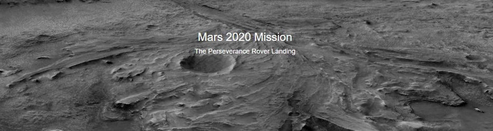
Landing zone for Mars 2020 mission (Credit: Ryan Anderson, USGS).
The time is finally here!
When you’re planning to explore someplace new, it’s always a good idea to bring a map so you can avoid dangerous terrain. This is true whether you’re heading out for a hike on Earth or you’re landing a rover on Mars. In either case, the USGS has you covered.
After nearly seven months of travel through space, NASA’s Perseverance rover will touch down on Mars on Thursday, February 18. The mission’s goals are to search for evidence of past life and habitable environments in Jezero crater and collect and store samples that, for the first time in history, could be returned to Earth by a future mission.
The intricate landing sequence, known as Entry, Descent and Landing, or EDL, is guided by the most precise maps of Mars ever created, courtesy of the USGS Astrogeology Science Center. To safely land on the rugged Martian landscape, the spacecraft will use a new technology called “Terrain Relative Navigation.” As it descends through the planet’s atmosphere, the spacecraft will use its onboard maps to know exactly where it is and to avoid hazards as it lands on the planet’s surface. For the navigation to work, the spacecraft needs the best possible maps of the landing site and surrounding terrain.
“As much as we would love to manually steer the spacecraft as it lands, that’s just not possible,” said Robin Fergason, USGS research geophysicist. “Mars is so far away -- some 130 million miles at the time of landing -- that it takes several minutes for radio signals to travel between Mars and Earth. By using the maps we created, the spacecraft will be able to safely steer itself instead.”
The USGS initially developed two maps for the Mars 2020 mission, including a surface terrain map that spans the landing site and much of the surrounding area and a high-resolution base map that was used by researchers to accurately map surface hazards at the landing site. The terrain map and maps of surface hazards traveled aboard the spacecraft and will be used to help it land safely. The base map will continue to serve for mission operations on Earth as scientists plot where the rover will explore once it’s on the ground. All the maps have been aligned with unprecedented precision to each other and to global maps of Mars to ensure that they show where everything really is.
In addition to the onboard maps used during the descent, USGS researchers also assisted in publishing a new geologic map of Jezero crater and Nili Planum – the ancient, cratered highlands where the crater impacted. The geologic map covers the landing site and surrounding terrain that the rover will encounter on its travels during the course of its mission. The geologic map is at a similar scale to our own USGS topographic maps, which is quite an impressive feat given that no one has ever set foot on the Martian surface, which is literally worlds away. The full extent of the geologic map covers roughly 40 square miles and includes some of the oldest terrain on Mars. And most importantly, the area being explored shows a rich history of diverse surface processes involving liquid water – an essential feature for life.

Geologic Map of Jezero crater on Mars (Credit: USGS).
“Exploration is part of human nature,” said Jim Skinner, USGS research geologist. “I’m excited to see what the rover sees and how its discoveries will expand our knowledge of the Martian surface and the planet’s geologic history.”
Beyond mapping, once the Perseverance rover lands, several USGS scientists will continue to be involved in the day-to-day operations of the rover. In fact, as soon as Perseverance’s wheels roll out onto the Martian soil, USGS researchers Ken Herkenhoff, Ryan Anderson and Alicia Vaughan will continue to support NASA’s mission of unlocking the mysteries of the red planet by supporting two of the instruments onboard – the Mastcam-Z and SuperCam. Both instruments are mounted atop the remote sensing mast of the rover and were selected to help carry out the mission’s goals to search for evidence of past life.
What will we learn about Mars over the next year? Was there life on Mars and was it in Jezero crater?
We don’t yet know. But we are excited to find out.
The USGS first began mapping objects in space in the 1960s while preparing astronauts for the Apollo missions. Back then the priority was the Moon. Efforts to map other planets started in the 1970s. With Mars specifically, the first USGS maps came out in 1978 based on imagery from the Mariner 9 mission. The 1980s brought updated imagery and updated maps thanks to the Viking Orbiter. But the most exciting USGS contributions came in the late 1990s and early 2000s when better images of the Martian surface allowed USGS to precisely map landing sites for Mars rover missions. The Mars 2020 mission is just the most recent opportunity that the USGS has had to improve the understanding of Mars and contribute to the further exploration of space.
For more details about USGS involvement in the Perseverance rover mission, visit the USGS Astrogeology Science Center website.
For the latest news about the mission, visit the NASA Mars 2020 mission website.
Related:

Geologic map of Jezero crater and the Nili Planum region, Mars
The cratered highlands located northwest of Isidis Planitia have been recognized as one of the best preserved Noachian landscapes currently exposed on Mars; the area hosts a record of diverse surface processes, diagenesis, and aqueous alteration. This region has consistently been considered a high priority for landed-mission exploration and...
Sun, Vivian Z.; Stack, Kathryn M.View Citation

Evaluating stereo DTM quality at Jezero Crater, Mars with HRSC, CTX, and HiRISE images
We have used a high-precision, high-resolution digital terrain model (DTM) of the NASA Mars 2020 rover Perseverance landing site in Jezero crater based on mosaicked images from the Mars Reconnaissance Orbiter High Resolution Imaging Science Experiment (MRO HiRISE) camera as a reference dataset to evaluate DTMs based on Mars Express High...
Kirk, Randolph L.; Fergason, Robin L.; Redding, Bonnie L.; Galuszka, Donna M.; Smith, Ethan; Mayer, David; Hare, Trent M.; Gwinner, KlausThe mineral diversity of Jezero crater: Evidence for possible lacustrine carbonates on Mars
Noachian-aged Jezero crater is the only known location on Mars where clear orbital detections of carbonates are found in close proximity to clear fluvio-lacustrine features indicating the past presence of a paleolake; however, it is unclear whether or not the carbonates in Jezero are related to the lacustrine activity. This distinction is critical...
Horgan, Briony H. N.; Anderson, Ryan; Dromart, G.; Amador, Elena S.; Rice, Melissa S.Source: USGS
