


California and National Drought Summary for February 16, 2021
Summary
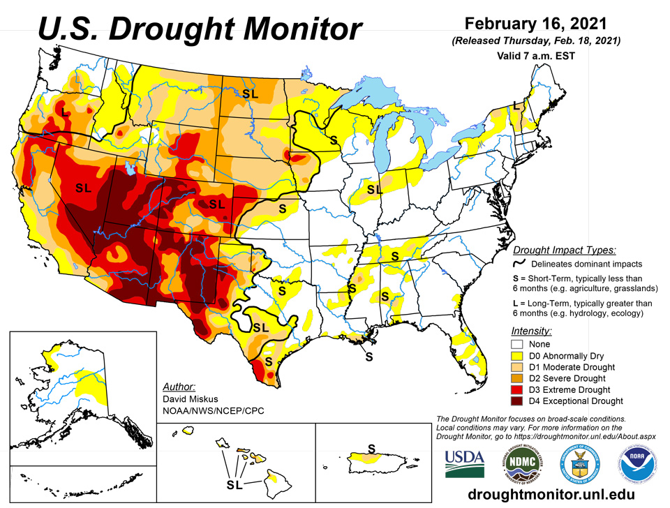
February 18, 2021 - Arctic air spilled into the Nation's midsection and persisted throughout the week, producing weekly departures of more than 25 deg F below normal from the northern Plains and upper Midwest southward into Texas. Numerous daily record lows were broken, with minimums plunging to -50 deg F in the northern Plains, and sub-zero readings southward into the Texas Panhandle. In contrast, high pressure over the Southwest and Southeast kept temperatures above-normal for the week. With several storm systems traversing along the boundary of the cold vs mild air, ample precipitation, much in the frozen form, fell on most of the West Coast, Intermountain West, Rockies, southern and central Plains, and much of the eastern third of the U.S. The combination of extreme cold and frozen precipitation across the South and Southeast taxed the power grid, made transportation hazardous, and brought down trees. The snows, however, were welcomed in the West as snow packs and basin snow water equivalents (SWE) increased throughout the West, although many basins were still below normal as of Feb. 16, especially in the southern Rockies. Frigid conditions also enveloped Alaska, with precipitation limited to western and southwestern sections. Shower activity continued across Puerto Rico, especially along the northern and eastern portions, but rain was lacking in the northwest. Across Hawaii, a weak cold front brought some showers early in the period, with trade wind conditions and windward showers later in the week.
Northeast
After a wet fall and early winter which greatly improved the summer drought in the Northeast, January was quite mild and dry, with drought lingering in northern New England. Across most of New England, precipitation during the past 30 days was only 50-75% of normal, accumulating deficits of 1-2 inches. With the first 6 days of this period relatively dry and cold, some deterioration was likely. Day7, however, saw a storm drop widespread light to moderate (0.5-1.5") precipitation across the Northeast, putting a halt to any possible degradations this week, along with providing a fairly decent blanket of snow for most of the region. Therefore, no changes were made this week.
Southeast
A series of storm systems dropped widespread moderate to heavy precipitation across the Southeast, although the greatest amounts (more than 4 inches) mainly fell on non-drought areas. Nevertheless, light to moderate totals (1.5-3.5") were measured in portions of Alabama, Georgia, northern and central Florida, western North Carolina, and coastal South Carolina, and that was enough to remove the D1 areas in northern and southern Alabama and shrink the D0 in portions of the aforementioned states. 7-day averaged USGS stream flows have also responded to the precipitation, with most gauges in the Southeast rated in the above-normal to record high categories. In contrast, not every Southeastern location received decent precipitation. Where less than an inch of precipitation fell, D0 slightly expanded (northeastern Alabama, west-central and southern Florida), and lingering short-term deficits of 4-6 inched remained in southwestern Alabama (D1).
South
Arctic air set-up shop in parts of the region, especially Oklahoma, Texas, northern Louisiana, Arkansas, northern Mississippi, and western Tennessee, with wintry weather blanketing or glazing many parts of these states. Although the precipitation was welcome after a rather dry 30-60 days prior, the form it came in (frozen) was not, nor was the Arctic air. With light to moderate totals (0.5-2 inches) from south-central and eastern Texas northeastward across the remaining Southern states, and heavier totals (2-5 inches) in southern sections of Louisiana and Mississippi, some D0 and D1 was improved, especially along the central Gulf Coast. However, since there were 60-day deficits of 3-6", the precipitation in the lower Mississippi Valley was not great enough to eliminate them, thus many areas remained unchanged. But with the combination of the extreme cold (no evaporation) and widespread precipitation, no deteriorations were made this week.
Midwest
With bitterly cold conditions in place across much of the Midwest, and light precipitation generally confined to eastern locales (e.g. Illinois, Indiana, Ohio, Kentucky, and lower Michigan), status-quo was the best bet. However, the past 90-days have been unusually dry (40-60% of normal) in the western Great Lakes region, and with 90-day SPIs in the D2-D4 range, D0 was added in northeastern Wisconsin, Upper Peninsula of Michigan, and northern lower Michigan. But impacts are basically non-existent with a decent snow covering the ground and frigid temperatures that prevent any melting. Southern lower Michigan was also being considered for D0 expansion, but Day7 brought moderate snowfall and quelled any D0 addition. In western Iowa, continued rounds of snow during the past 30-90 days have pushed short-term indices into the normal to wet categories, and with this “water in the bank” for future snow melt, some slight improvements were made to the D2 areas – however, these improvements assume that the snow melt will infiltrate into the topsoil and not runoff or sublimate, so be careful – especially since this area also has a long-term drought (subsoil) component.
High Plains
While bitterly cold air enveloped the High Plains this week (except western Colorado and southwestern Wyoming), frequent storm systems have zipped their way across much of the region, dropping snow across both high and low elevations. After several weeks of decent precipitation, some improvements were warranted for those areas with surplus precipitation out to 2-3 months and wet short-term SPIs. Although longer-term SPIs (>6 months) were still severe, the short-term conditions have been wetter, and this is what these improvements were attempting to depict. This included 1-cat improvements to parts of Nebraska and adjacent western Iowa, sections of Wyoming, southeastern Montana, northeastern Kansas, and portions of Colorado. As mentioned in the Midwest summary regarding western Iowa, low elevation snow melt and infiltration into the soils can have problems, so take these improvements with caution. Fortunately, higher elevation (mountain) snows tend to melt more evenly and slowly. In sharp contrast, storms and precipitation continued to elude the frozen northern Plains, but unfortunately the bitterly cold Arctic air did not.
West
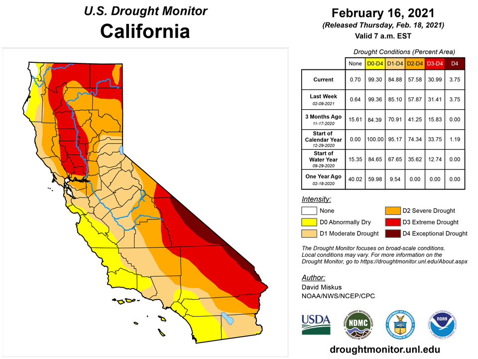
Another in a series of Pacific storms battered the West Coast and tracked southeastward across the Intermountain West and Rockies, dropping heavy precipitation (more than 4 inches) along the Washington-Oregon-northwest California coasts and on the Cascades, with lighter totals (2-4 inches) falling on the Sierra Nevada. Beneficial precipitation fell farther east on higher elevations of northeastern Oregon, most of Idaho, northern Nevada, central Utah, western and eastern Wyoming, western Colorado, northeastern Arizona, and most of New Mexico. With precipitation increasing over the past 30 days or so, short-term indices not showing D3-D4 on multiple time scales (short-term much wetter), and SNOTEL basin average SWE (as of Feb. 16) improving and getting closer to normal (but still below), some improvements were justified to depict areas with the aforementioned conditions, although long-term drought still remained (going back to the failed southwest summer monsoon). However, there were some small areas of deterioration as not all locales received this beneficial moisture. This included portions of Oregon and Wyoming. No improvements were made for areas with very large deficits, lower weekly precipitation totals, and smaller basin SWEs. With February normally one of the wettest months for California, the moderate precipitation falling on the Sierra Nevada this week was enough to keep conditions stabilized. As of Feb. 16, the northern, central, and southern Sierra Nevada SWEs stood at 68%, 76%, and 54%, and the state average was 69%. When applied to an April 1 (normal peak snow) date, these values dropped to 54, 59, 40, and 53%, respectively. Basin SWEs remained the lowest in the southern Rockies (6-45% of normal), even though light precipitation fell across most of New Mexico.
Alaska, Hawaii, and Puerto Rico
With an Arctic air mass enveloping most of Alaska (except the southwest - Aleutians), drier weather also prevailed, and with changes made last week with respect to the January update, status-quo was the call this week.
In Hawaii, a weak cold front early in the week was followed by trade wind conditions. On western Maui, late January rainfall has translated to improved NDVI conditions, except where FSA said D2 was appropriate for the Kihei and central valley. Thus, the D2 was split, with improvement to D1 down the southward flank of Haleakala while D2 was kept from Kepuni to Kaupo and the Kihei/central valley/West Maui regions. On the Big Island, D0 was returned to the Humuula Saddle region between Mauna Kea and Mauna Loa due to stressed vegetation. On Oahu, recent rains were enough for a 1-cat improvement on the leeward side.
In Puerto Rico, light showers continued across northern and eastern sections of the island, preventing any further deterioration, but it was not enough for any major improvement to the dryness and drought in the northwest.
Pacific Islands
During the Northern Hemisphere winter months, dry northeast trade winds emanating from the North Pacific High shift southward, and the Inter-Tropical Convergence mechanisms also shift southward and are not as active as in the summer months. This pattern brought dry weather to northern portions of Micronesia during this USDM week (02/10/21-02/16/21), notably the Marianas and northern Marshall Islands (RMI). Further south in these U.S.-Affiliated Pacific Islands (USAPI), a near-equatorial trough with a weak circulation dominated the weather over Palau and much of Yap State, while trade-wind convergence and embedded surface troughs brought rain to central and eastern parts of the Federated States of Micronesia (FSM) and southern parts of the RMI. Cold front/shear line fragments teased the Marianas but brought little rain. South of the equator, a normally active South Pacific Convergence Zone (SPCZ) makes this time of year (summer in the Southern Hemisphere) the wettest season for the Samoan Islands. But this week the SPCZ was shifted to the west with a ridge of high pressure dominating the weather over American Samoa.
Satellite-based estimates of 7-day precipitation (QPE) showed a large band of 2+ inches of rain stretching across Palau and much of the FSM, with embedded areas of 4+ inches. A band of 2+ inches of precipitation was evident over southern parts of the RMI. These reflected the broad circulation and trough in the west and the narrower region of trade-wind convergence in the east. Little to no rainfall was indicated on the QPE north of these bands, where drier trade winds dominated, or across southern parts of Chuuk and Pohnpei States. The QPE revealed areas of 1+ inches of rain west and northeast of the Samoan Islands, with streaks of half an inch or more across American Samoa between these areas.
The Republic of Palau remained free of dryness. Palau IAP received more than 2 inches, while Koror COOP reported 5.24 inches.
The Mariana Islands remained dry with Rota and Saipan experiencing continued abnormal dryness, while abnormal dryness was introduced this week for Guam. Precipitation for Guam was only 0.02 inches, although one inch of rain weekly is needed to meet minimum water needs. Grass was beginning to turn brown and become crunchy on Guam. Rota reported 0.12 inches for the week. Rainfall at Saipan IAP was 0.36 inches, at Saipan ASOS was 0.59 inches, and at Saipan NPS was 0.18 inches.
The Federal States of Micronesia were mostly wet for the week with a couple of drier locations. Fananu remained abnormally dry, reporting 0.74 inches. All other FSM locations, apart from Kapingamarangi, received from 2 to nearly 10 inches. Kapingamarangi remained at D3 after receiving 0.87 inches for the fourth week of less than an inch of rain. Conditions were dire for Kapingamarangi and a state of emergency was declared by the state. Well water has been unsafe to drink since possibly September or October. Some springs were dry, and streams have been low for roughly three weeks. Residents were able to fill all of their reserve water catchment tanks at the end of January, but the large community concrete water tank remained low. At present, personal private tanks were around one-fourth of capacity and the community concrete tank was just below half. IOM and the Micronesia Conservation Trust both sent eight 1,600 gallon water tanks on the last trip to Kapingamarangi. Pohnpei State will be transporting food to Kapingamarangi in coming days as all crops were in in very bad shape, especially taro and breadfruit.
Conditions continued to be mixed for the Marshall Islands with some locations abnormally dry or in drought. Kwajalein and Wotje remained at D2 as Kwajalein received 1.17 inches, while Wotje reported no rain for the past week. Jaluit continued to be abnormally dry, reporting 0.85 inches. Ailinglaplap, Mili and Majuro received 1.99 inches to nearly four inches. The Majuro reservoirs held 27.357 million gallons on Feb. 15 after benefiting from recent rain and hold 36 million gallons at capacity.
American Samoa remained free of drought. Pago Pago received 0.86 inches, Siufaga Ridge reported 2.25 inches, and Toa Ridge received 1.38 inches.
Virgin Islands
The U.S. Virgin Islands remained dry for another week. Satellite-based estimates of 7-day precipitation (QPE) showed rainfall across St. Thomas ranged from an inch on the western end of the island to as little as a quarter of an inch in the east. St. John’s rainfall varied from 0.10 to 0.50 inches. The western two-thirds of St. Croix received up to 0.10 inches, while the eastern third remained dry.
Precipitation at St. Thomas’s CoCoRaHS stations varied from 0.44 to just under an inch for the past week. The SPI values for the Cyril E King Airport indicated normal conditions at 6 and 9 months, abnormal dryness at 1 and 12 months, and moderate drought conditions at 3 months. St. Thomas remained in moderate drought.
St. John also remained in moderate drought for another week. Windswept Beach reported 0.71 inches, while other CoCoRaHS stations reported 0.83 inches and 0.91 inches. The SPI values for Windswept Beach indicated moderate drought at 3 months, abnormal dryness at 1 and 12 months, and drought-free conditions at 6 and 9 months.
St. Croix entered moderate drought this week. Rainfall at Henry Rohlsen AP amounted to 0.23 inches, and CoCoRaHS stations reported precipitation ranging from 0.27 to 0.68 inches. The SPI values for Henry Rohlsen AP indicated drought-free conditions at 1 and 6 months, abnormal dryness at 9 and 12 months, and moderate drought at 3 months.
Looking Ahead
During the next 5 days (February 18-22), temperatures should remain below normal across much of the lower 48 States, although moderating temperatures are expected later in the period in the northern Plains. A vigorous storm system will impact the Southeast and Northeast early in the period, with significant snow and icing possible. Tranquil weather should prevail in the Nation’s midsection, while a series of storms hit the Pacific Northwest, bringing heavy rains to the coast and heavy snows to the Cascades, and light precipitation to the Rockies.
The ensuing 5 days (February 23-27) brings enhanced chances of above-normal precipitation to the northern tier of States, from Washington eastward to the Great Lakes region, and across Alaska. The odds favor subnormal precipitation across the southern half of the Nation. With a pattern change, above-normal temperatures are most-likely across the northeastern quarter of the country, especially in the upper Midwest, across southern sections of the Southwest, and in southwestern Alaska. In contrast, subnormal readings are anticipated in the Northwest and the remainder of Alaska.
Author(s):
David Miskus, NOAA/NWS/NCEP/CPC
Denise Gutzmer, National Drought Mitigation Center
Dryness Categories
D0 Abnormally Dry—used for areas showing dryness but not yet in drought, or for areas recovering from drought.
Drought Intensity Categories
D1 Moderate Drought
D2 Severe Drought
D3 Extreme Drought
D4 Exceptional Drought
Drought or Dryness Types
S Short-Term, typically less than 6 months (e.g. agricultural, grasslands)
L Long-Term, typically greater than 6 months (e.g. hydrologic, ecologic)
Source: National Drought Mitigation Center

