


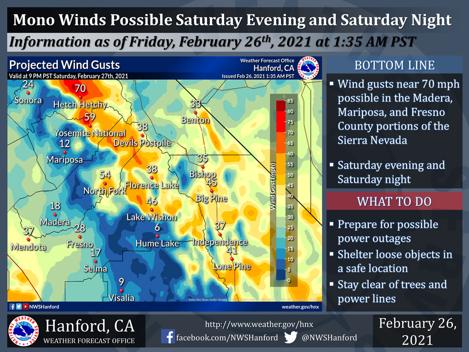
February 26, 2021- The National Weather Service Hanford Office reports northeast wind gusts near 70 mph are possible in the Mariposa, Madera, and Fresno County portions of the Sierra Nevada Saturday evening and Saturday night.
Damaging wind gusts may blow down trees and power lines.
On the graph are projected wind gusts valid at 9 PM PST Saturday evening, February 27th, 2021.
  Area Forecast Discussion
  National Weather Service Hanford CA
  400 AM PST Fri Feb 26 2021


  .SYNOPSIS...Dry weather and sunny skies will prevail today
  with seasonable temperatures. Saturday will be a little cooler
  with breezy to windy conditions developing. Continued dry and
  trending warmer Sunday and Monday. There is the potential for
  wet weather Tuesday and Wednesday, but confidence remains low.

  &&

  .DISCUSSION...
  Satellite imagery shows clear skies across the region with a
  dry northwest flow aloft. While the skies are clear and winds
  are light, the lack of boundary layer moisture will probably
  inhibit fog formation across the San Joaquin Valley once again.
  With abundant sunshine, temperatures will be a little warmer
  than yesterday and will probably top out slightly above normal
  for late February. Westerly winds will probably increase in the
  Kern County mountains late this afternoon with gusty conditions
  through the evening. Local gusts will probably reach advisory
  level, but it will probably be a fairly short-lived event with
  winds diminishing overnight.

  An upper trough will drop down over the Great Basin on Saturday.
  Dry weather will persist but it will probably bring some modest
  cooling and an increase in winds. Gusty conditions will develop
  across the San Joaquin Valley and may warrant a Wind Advisory on
  Saturday. Also, with the lack of rainfall, there will probably
  be some areas of blowing dust to deal with too. Another area of
  concern is in the Sierra Nevada where gusty northeast winds are
  probable on Saturday night as strong surface high pressure builds
  over the Great Basin. A Wind Advisory may be needed if subsequent
  model runs continue with this idea.

  The trough will probably drop down over Arizona on Sunday as high
  pressure builds over the west coast. This will bring lighter wind
  along with a warming trend into Monday. Forecast confidence drops
  off after that as models struggle with the next trough dropping
  down from the north. The most probable solution at this time is a
  closed low forming offshore then eventually shifting inland around
  midweek. The National Blend of Models suggests precipitation could
  arrive by Monday night, but that is probably a little too early.
Source: NWS

