


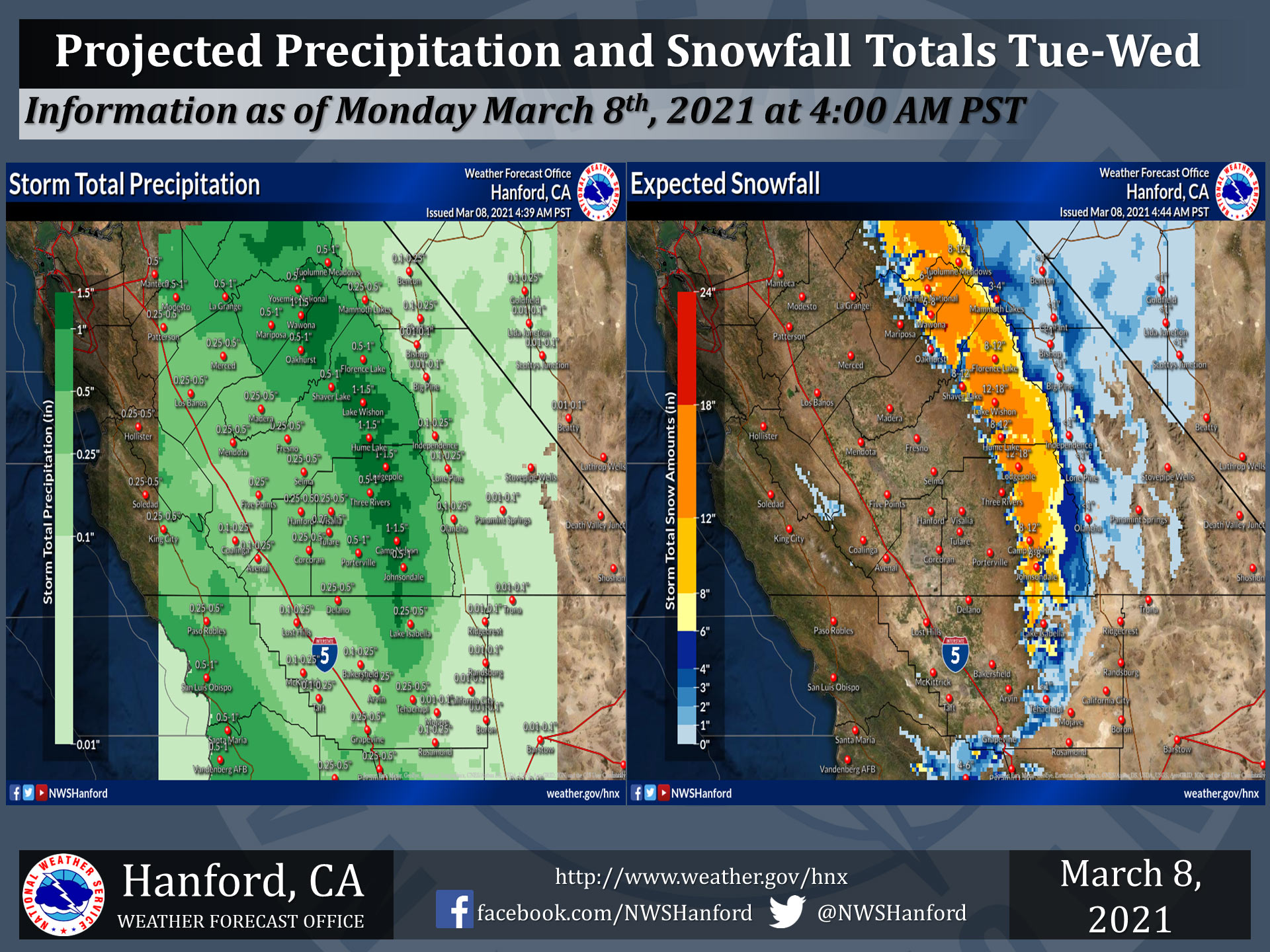
Projected rainfall totals for Mariposa: 0.50" to 1.00"
Projected rainfall totals for Oakhurst: 0.50" to 1.00"
Projected rainfall totals for Yosemite Valley: 1.00" to 1.50"
March 8, 2021 - The National Weather Service Hanford Office reports a cold storm system will bring valley rain and mountain snow to the forecast area on Tuesday and Wednesday.
Afternoon thunderstorms are possible in the San Joaquin Valley on Wednesday, which could lead to brief heavy rain, gusty winds, and small hail.
  National Weather Service Hanford CA
  139 PM PST Sun Mar 7 2021


  .SYNOPSIS...A dry southwesterly flow will prevail through Monday
  before a slow moving system brings cooler temperatures and
  unsettled weather to the forecast area Tuesday through Thursday.
  Drier weather and milder temperatures will return Friday.

  &&

  .DISCUSSION...
  A dry west-southwest flow aloft is bringing high clouds over the
  region today. This pattern is expected to continue through Monday
  with temperatures near or just a few degrees below normal before
  a low pressure system drops out of the Gulf of Alaska and approaches
  central California Tuesday. Temperatures will cool below normal
  Tuesday, reaching 8-15 degrees below normal most areas Wednesday.

  Models are in good agreement today on the timing of this system
  moving through Tuesday through Thursday. There is a slight chance
  of very light precipitation in the northern part of Yosemite NP on
  Monday afternoon, but the main area of precipitation does not
  begin until Tuesday afternoon, mainly Fresno county northward.
  Precipitation will spread south Tuesday night and continue
  Wednesday. With colder air aloft as the trough move more directly
  over central California Wednesday, the airmass becomes more
  unstable and precipitation will change to showers with a slight
  chance of afternoon thunderstorms in the San Joaquin Valley.
  Given the fact that this system is out of the Gulf and AK, it will
  be a cold storm and snow levels will lower from around 4000 feet
  at the onset of precipitation on Tuesday to around 3000 feet
  Tuesday night. Adverse impacts to travel will be likely over the
  mountains and foothills Tuesday night through Wednesday night due
  to winter weather.

  The ensemble model runs are showing better agreement in moving
  the trough pushing into the desert southwest by Thursday, with
  showers diminishing in the San Joaquin Valley Wednesday night and
  showers continuing in the mountains Thursday. A few light showers
  may continue in the Sierra Nevada on Friday. There is still some
  uncertainty in the forecast Friday into next weekend as there
  continues to be a fair amount of spread in the ensembles during
  that period. However, they do seem to be beginning to trend more
  toward building a ridge of high pressure into California by
  Saturday which would bring warming temperatures for the weekend,
  so will continue with that idea with highs warming back to near
  normal by Saturday.
Source: NWS
