


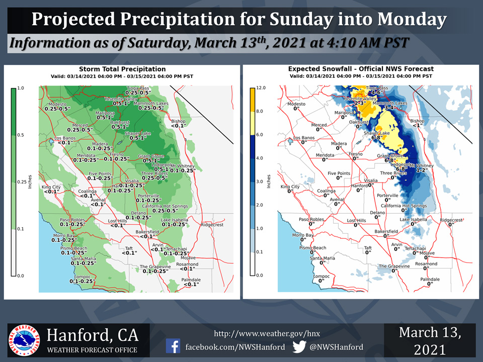
Projected rainfall totals for Mariposa: 0.50" to 1.00"
Projected rainfall totals for Oakhurst: 0.50" to 1.00"
Projected rainfall totals for Yosemite Valley: 0.50" to 1.00"
March 13, 2021 - The National Weather Service Hanford Office reports a storm system will impact Central California Sunday into Monday resulting in widespread precipitation.The heaviest precipitation will fall primarily in the Sierra Nevada mountains and foothills, where a Winter Storm Watch is in effect for Sunday and Monday evening above 4000 feet.
Precipitation is also possible in the Southern San Joaquin Valley, with thunderstorms possible on Monday afternoon.
  Area Forecast Discussion
  National Weather Service Hanford CA
  151 PM PST Fri Mar 12 2021


  .SYNOPSIS... Temperatures will rebound back to seasonal
  averages this weekend, and a brief period of dry weather is in
  store. A return of cooler than average temperatures, wet weather,
  and mountain snow are expected to impact the region by late
  Sunday into Monday. Otherwise, a warming trend will occur by
  midweek.


  .DISCUSSION...

  On Saturday and Sunday, expect seasonal, though milder,
  temperatures during the daytime. Dry weather will prevail,
  although some clouds could develop over the mountains on Saturday
  afternoon due to residual moisture.

  The potential for precipitation on Sunday night is increasing, as
  well as the possibility of snow reaching below the pass levels in
  the Kern County mountains and into the Sierra Nevada foothills.
  Snow levels could reach as low as 3,000 feet by early Monday
  morning in the Kern County mountains, including towards Tehachapi
  and the Grapevine. Snow levels may be around 2,500 feet elsewhere,
  including into the Sierra Nevada foothills from Tulare County
  northward. The probabilities for lower elevation snow in the
  Sierra Nevada and Kern County mountains, as well as gusty winds in
  the Kern County desert and through/below the mountain passes are
  increasing significantly for Sunday night and Monday, compared to
  this time yesterday. Gridded forecast guidance (i.e., National
  Blend of Models, or NBM) now shows about a 40 percent chance for
  advisory level (45 mph gusts or higher) portions of the Kern
  County desert and mountains on Monday. In addition, our guidance
  (NBM) is showing at least a 70 percent chance of snow levels
  falling below 4,000 feet over much of the mountains. So, we can at
  least expect a return of colder and wet weather by early next
  week.

  On Tuesday, cooler than average temperatures will continue, but a
  warming trend will likely commence once again as a ridge of high
  pressure passes over California. Daytime highs after midweek will
  likely warm considerably, or back to at least a few degrees above
  average. Highs in the valley and desert are projected to reach
  the lower 70s by Thursday.
Source: NWS
