


California and National Drought Summary for March 16, 2021
Summary
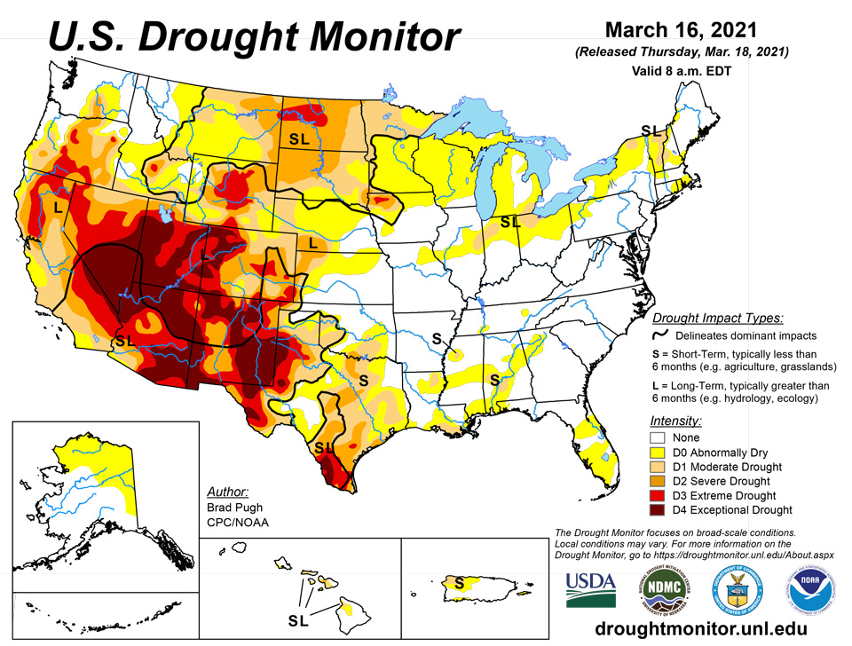
March 18, 2021 - A vigorous and slow-moving area of mid-level low pressure tracked from the Four Corners region to the Central Great Plains from March 13 to 15. Widespread precipitation (rain and snow totaling 2 to 6 inches, liquid equivalent) fell across the Central Rockies, Central Great Plains, and Lower Missouri River Basin. Snowfall amounts ranged from 2 to 4 feet from Colorado north to Wyoming. However, across North Dakota, dry weather continued. As a low pressure system tracked eastward, rainfall (locally more than 2 inches) overspread the Ohio and Tennessee Valleys along with parts of the Southeast on March 14 and 15. Mostly dry weather prevailed along the East Coast from March 9 to 15. During this 7-day period, below normal precipitation was observed throughout much of the Pacific Northwest while precipitation amounts exceeded 2 inches (liquid equivalent) for the Sierra Nevada Mountains and coastal ranges of California. A low pressure system and trailing front resulted in heavy rainfall and flooding across parts of the Hawaiian Islands during early March.
Northeast
Mostly dry weather prevailed during the past week and 30-day precipitation has averaged below normal for most of this region. Small areas of short to long-term moderate drought (D1) continue across parts of northern New York, Vermont, and New Hampshire. Abnormal dryness (D0) was introduced to southeast New England where little or no precipitation has occurred through the first half of March and short-term precipitation deficits are increasing.
Southeast
Short-term precipitation deficits continue to increase throughout the Florida Peninsula and along the northern Gulf Coast, prompting an expansion of abnormal dryness (D0) for these areas. Conversely, heavy rain that fell just prior to 12Z Tuesday, March 16 led to improvements across parts of west-central Alabama. The largest 60-day precipitation deficits (2 to 6 inches) are centered across the southern half of Alabama where 28-day streamflows are running between the 10th to 24th percentile and soil moisture is below the 30th percentile. Maximum temperatures recently warmed above 80 degrees F across southern Alabama, increasing evapotranspiration rates. According to the Alabama Forestry Commission, 261 wildfires charred about 5,700 acres between March 7th and March 13th. Despite these recent drying trends (prior to March 16), the abnormal dryness and moderate drought areas depicted across Georgia and Alabama were not expanded this week and will be reassessed next week. Below normal precipitation during the past 60 days extends northeast to the upstate of South Carolina and this area will be closely monitored in subsequent weeks.
South
As an intense mid-level low pressure system crossed the Four Corners Region, an early season severe weather outbreak occurred across the Texas Panhandle on March 13. According to the Storm Prediction Center, more than a dozen tornado reports were tallied. Along with the severe weather, locally more than 1 inch of rainfall was observed across the Texas Panhandle, resulting in drought improvement. This 1-category improvement extended east to parts of southwest Oklahoma where Oklahoma Mesonet gauges recorded 1 to 2.5 inches of rainfall this past week. Elsewhere across the southern Plains, western Gulf Coast, and lower Mississippi Valley, mostly dry weather prevailed along with above normal temperatures and periods of increased winds. Based on short-term indicators, abnormal dryness (D0) and drought (D1-D3) were expanded in coverage across south-central Oklahoma and Texas. Wheat is entering the critical hollow stem stage across south-central Oklahoma. The northeast quarter of Louisiana has received less than 4 inches of precipitation during the past 60 days which prompted a slight increase in the coverage of short-term moderate drought (D1). An increase in the coverage of D0 was made across parts of Louisiana and Mississippi, due to increasing short-term precipitation deficits along with soil moisture and 28-day streamflows below the 30th percentile.
Midwest
A major storm brought widespread heavy precipitation (1 to 3 inches, liquid equivalent) to western Iowa and Missouri. This recent precipitation resulted in a 1-category improvement for areas that received more than 1.5 inches of precipitation. A slight eastward expansion of abnormal dryness (D0) across northeast Missouri, which merged with the ongoing D0 in west-central Illinois, was supported by short-term SPI values and decreasing 28-day average streamflows. The largest 90-day precipitation deficits (2 to 4 inches) for this region exist across the northern half of Indiana and Ohio along with parts of Michigan. Based on 60 to 90 day SPIs, along with low soil moisture (below the 30th percentile), abnormal dryness (D0) was expanded to include more of eastern Indiana and bordering areas of Ohio with a slight expansion of short-term moderate drought (D1) across northern Ohio. Conditions improve farther south over Ohio where a slight reduction in abnormal dryness was warranted.
High Plains
A strong and slow-moving low pressure system brought widespread heavy precipitation (more than 2 inches, liquid equivalent) to northeast Colorado, southeast Wyoming, southwest South Dakota, northern Kansas, and much of Nebraska. Denver, Colorado received 27.1 inches of snowfall on March 13 and 14, making it the 4th largest snowfall on record. According to the storm summary from the Weather Prediction Center, other notable snowfall amounts included: 42” near Buckhorn Mountain, CO, 27” near Hot Springs, SD, and 19” near Gering, NE. The highest snowfall amount reported from this storm was 52.5” at Windy Peak, WY. The heavy snowfall brought snow water content close to average for mid-March across most of Colorado and Wyoming. This recent heavy precipitation also eliminated precipitation deficits and resulted in precipitation surpluses for the past 90 days for much of the central Plains. Therefore, a broad 1-category improvement was made for areas that received 1 inch or more of precipitation. Based on SPI values at various time scales, small areas of 2-category improvements were justified for the central Great Plains west to the central Rockies. Please note that the drought impact type was changed from SL (short and long-term) to L (long-term) drought only where the heaviest precipitation occurred, but where long-term indicators such as SPI support a continuation of D1+ long-term drought.
Based on 120-day SPI values, a 1-category improvement was made to parts of southwest Wyoming and bordering areas of southeast Idaho and northeast Utah. Farther to the north, the northern third of South Dakota and North Dakota missed out on the drought relief. During the past two weeks, widespread 1 to 2-category degradations were made and only slight changes were necessary this week. However, based on soil moisture below the 5th percentile and SPI values, D3 (extreme) drought was introduced to parts of North Dakota. If below normal precipitation persists later into the spring when temperatures warm, rapid intensification of drought conditions may occur.
West
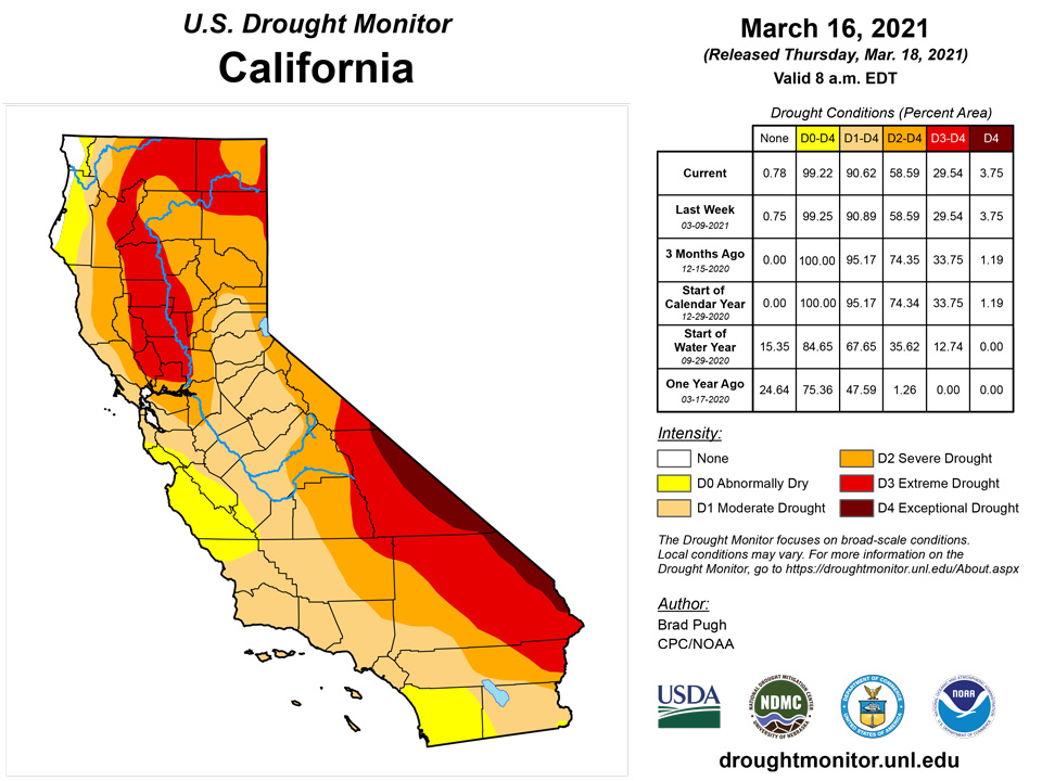
Below normal precipitation prevailed across the Pacific Northwest during the past week. Recent dryness during the past 30 days and below normal 28-day average streamflows supported a northward expansion of abnormal dryness (D0) across eastern Washington. Near to above normal precipitation was generally observed throughout California, the Great Basin, and Desert Southwest during early to mid-March. As of March 16, snow water content is running 60 to 75 percent of average across the Sierra Nevada Mountains. No changes were made this week to much of the moderate (D1) to exceptional (D4) drought areas across the West.
Alaska, Hawaii, and Puerto Rico
Abnormal dryness continues for northern and eastern Mainland Alaska with no changes this week. The water year precipitation remains below 70 percent for northeast parts of Alaska.
Heavy rainfall continued to affect parts of Hawaii during the second week of March. A low pressure system and associated front resulted in additional heavy rainfall for Kauai, Oahu, and the Big Island. Numerous preliminary reports of 6-day totals, ending on March 13, exceeded 10 inches across parts of these islands and maximum amounts of more than 20 inches were reported. Much of this heavy rain fell outside of existing drought areas but improvements can be expected in subsequent assessments.
During the past week, above normal precipitation resulted in a decrease of abnormal dryness (D0) and short-term moderate drought (D1) across much of Puerto Rico. D0 was maintained for the islands of Vieques and Culebra.
Pacific Islands
The weather conditions across the U.S.-Affiliated Pacific Islands (USAPI) during this USDM week (03/10/21-03/16/21) consisted of dry trade winds across the Marianas and northern portions of the Marshall Islands (RMI) and Federated States of Micronesia (FSM) from Chuuk State eastward; trade-wind convergence and surface troughs within an Inter-Tropical Convergence Zone (ITCZ) over much of Chuuk State to the southern RMI; and a weak circulation and surface troughs over Yap State and Palau. Weak cold fronts/shear lines teased the Marianas and there was some coupling of surface convergence with upper-level divergence over western FSM and Palau. South of the equator, the South Pacific Convergence Zone (SPCZ) brought rain to American Samoa early in the week, then a ridge dried things out as the week progressed.
Satellite-based estimates of 7-day precipitation (QPE) showed two broken bands of precipitation -- one from the Philippines eastward across Micronesia and the second stretching southeastward from Indonesia past the Samoan Islands. Areas of 2+ inches of rain, with locally 4+ inches, were evident across the FSM and southern RMI. Less than an inch was indicated in a pocket over Palau, while little to no precipitation was detected by this tool over most of the Marianas and northern RMI. The SPCZ was represented by a northwest-to-southeast broken band of 0.5 to 2.0 inches of rain across the Samoan region.
For Saipan, Rota, and Guam, conditions varied widely while the Mariana Islands were relatively dry overall. Saipan had paltry rainfall ranging from nothing to just 0.03 inches, continuing a dry stretch of weather there. As a result, conditions degraded to short-term moderate drought. On Guam, 1.19 inches of rain fell at the airport, bringing them over their needed weekly rainfall. Reports from other parts of Guam indicate substantially more rainfall fell elsewhere, allowing grasses to green and the fire risk to subside. Thus, Guam has been improved to short-term abnormal dryness. On Rota, 1.26 and 1.28 inches of rain have been recorded the last couple weeks, respectively, and conditions have improved to short-term abnormal dryness there as well.
Normal conditions continued on Palau, where rainfall of 0.99 and 1.12 was recorded this week.
In the Federated States of Micronesia, short-term moderate drought improved to short-term abnormal dryness on Fananu, while no other changes were made to the drought depiction this week. At least 1.61 inches of rain have been recorded on Yap this week, and normal conditions continued there. At least 1.34 inches of rain fell on Ulithi this week, so normal conditions continued there as well. On Woleai, only 0.40 inches of rain has been reported, though a few days of data were missing. Given that over 4 inches of rain fell there last week, normal conditions continued. On Fananu, 4.37 inches of rain fell last week, and at least 2.02 inches have fallen there this week. Given the recent rainfall, water tanks have been refilling, and conditions have been able to improve from short-term moderate drought to short-term abnormal dryness on Fananu. On Chuuk, another wet week occurred with 4.91 inches of rain being recorded, and normal conditions continued. On Lukunor, 2.82 inches of rain were measured, breaking a streak of two consecutive weeks with below weekly minimum rainfall. Thus, drought-free conditions continued. Another drier week took place on Nukuoro, with only 1.07 inches of rainfall. While this is the third consecutive week below the weekly minimum, conditions in January and February were on the wetter side, so abnormal dryness has not developed. On Kapingamarangi, 3.51 inches of rain have helped to fill water tanks, though vegetation is still struggling there, and short- and long-term extreme drought continued for another week. Pohnpei received 7.50 inches of rain this week, so wet conditions continued there. Rainfall of 3.93 inches accumulated this week on Pingelap, so normal conditions continued there. On Kosrae, 8.06 inches of rain followed 6.02 inches last week, so wet conditions continued there.
Short-term moderate drought continued on Kwajalein, where 1.19 inches of rain fell this week. Ailinglapalap received 6.72 inches of rain this week after 8.14 inches fell last week, and wet conditions continued for another week. Jaluit received 1.79 inches of rain this week, and short-term abnormal dryness continued. No depiction was made for Utirik, as the data there were unavailable. Short-term extreme dryness continued with another dry week on Wotje. On Majuro, 2.61 inches of rain fell this week, and normal conditions continued. Mili received 4.96 inches of rain this week, and normal conditions continued there too.
Normal conditions continued for American Samoa this week. Toa Ridge received 0.59 inches of rain, Pago Pago received 1.78 inches, and 2.06 inches fell at Suifaga Ridge.
Virgin Islands
Mostly dry weather continued to envelop the U.S. Virgin Islands this week, aside from an area of rainfall indicated by radar data in northwest St. Croix. As a result, groundwater levels have continued to drop on St. John, St. Thomas, and St. Croix. Short-term precipitation deficits have worsened on St. Thomas and St. John, particularly at the three-month time scale, and severe short-term drought has now developed there. Short- and long-term moderate drought continued on St. Croix.
Looking Ahead
During the next 5 days (March 18 to 22), a low pressure system is forecast to bring widespread precipitation (0.5 to 2 inches, locally more) to the Ohio and Tennessee Valleys and Mid-Atlantic. Farther to the south across the Florida Peninsula, dry weather is likely to persist. Little to no precipitation is also forecast for the Southwest and northern Great Plains. As a mid-level area of low pressure progresses inland from the East Pacific, rain and high-elevation snow are expected to overspread the Pacific Northwest, northern California, and the northern and central Rockies.
The CPC 6-10 day extended range outlook (valid from March 23 to 27) favors above normal precipitation throughout most of the central and eastern U.S. except for the Florida Peninsula, where probabilities for below normal precipitation are slightly elevated. Increased chances of above (below) normal precipitation are forecast for the Southwest (West Coast). Above normal precipitation is favored for Alaska. Above normal temperatures are likely from the Mississippi River to the East Coast, while below normal temperatures are favored for much of the western U.S. and Alaska.
Author(s):
Brad Pugh, NOAA/CPC
Curtis Riganti, National Drought Mitigation Center
Dryness Categories
D0 Abnormally Dry—used for areas showing dryness but not yet in drought, or for areas recovering from drought.
Drought Intensity Categories
D1 Moderate Drought
D2 Severe Drought
D3 Extreme Drought
D4 Exceptional Drought
Drought or Dryness Types
S Short-term, typically less than 6 months (agriculture, grasslands)
L Long-term, typically more than 6 months (hydrology, ecology)
SL Area contains both short- and long-term impacts
Source: National Drought Mitigation Center

