


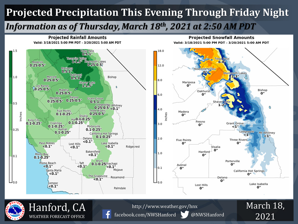
Projected rainfall totals for Mariposa: 0.50" to 1.00"
Projected rainfall totals for Oakhurst: 0.50" to 1.00"
Projected rainfall totals for Yosemite Valley: 1.00" to 1.50"
March 18, 2021 - The National Weather Service Hanford Office reports a storm system will impact Central California this evening through Friday night.The majority of precipitation associated with this storm system will fall Friday.
Snow levels will start at around 6,000 feet this evening, before falling to about 5,000 feet Friday evening.
  Area Forecast Discussion
  National Weather Service Hanford CA
  401 AM PDT Thu Mar 18 2021


  .SYNOPSIS...
  A warming trend is expected through Thursday. A trough of low
  pressure will pass through Northern California Thursday night and
  Friday. Precipitation associated with this trough of low pressure
  will trend lighter from northern areas to the southern locales in
  central California. Temperatures will be below seasonal values
  this weekend. Strong, gusty winds and increased chances of
  precipitation are possible in Central California early next week.

  &&

  .DISCUSSION...
  A low pressure system originating from the Gulf of Alaska
  currently centered over the eastern Pacific at 37N 138W per
  current satellite imagery will continue moving eastward into the
  Pacific Northwest. The associated cold frontal boundary is draped
  southward and currently beginning to transit into northern
  California and will move into central California later this morning
  bringing increased clouds and a breezy conditions along with showers
  and moderate rainfall at times through this evening.
  Precipitation amounts will trend higher in the northern parts of
  the CWA and lower southward into Kings, Tulare, and Kern Counties.

  Storm totals for the San Joaquin Valley will run from about a
  third of an inch in the Merced area to less than a tenth in the
  southern parts of the SJV. Higher elevations will see greater
  accumulations with around 1.25 inches in the Yosemite area to less
  than a tenth of an inch in the far southern Sierra and Kern
  County mountains. Snow levels look to start out about 6000 feet
  later this morning and increase to almost 8000 feet by late
  evening today and hover around that elevation through Friday
  night. Snow amounts will mostly range from 2 to 6 inches in the
  Yosemite area above 6000 feet with higher amounts from 6 to 12 in
  the highest elevations with localized heavier amounts possible in
  the far northern parts of the Sierras near Yosemite. A winter
  weather advisory has been issued above 6000 feet from Sequoia
  National Park northward to Yosemite National Park from 11 AM today
  until 5 AM Saturday to address this threat. Mountain areas above
  6000 feet from Fresno/Tulare county line southward will only see a
  trace to a couple inches of snowfall at most.

  Late Friday into Saturday the frontal boundary will transition to
  a more easterly to westerly orientation as the trough axis
  flattens out with the assoicated system weakening from a closed
  system to southerly moving hanging trough that will sit over
  central California. This will allow for unstable conditions and
  increased clouds to persist through Sunday. However, precipitation
  amounts will be minimal to non-existent. Any precipitation will
  be highly scattered and very light. Late Sunday the trough
  axis/frontal boundary will again begin moving southward and will
  once again increase light precipitation chances and breezy to gusty
  winds will be possible with the strongest winds in the pass areas
  and the Kern County mountains and desert areas.

  Weak ridging will move into the region on Monday giving us a break
  in precipitation and allow for a small warming trend to near
  normal levels. However, another system, this time an inside slider
  looks to move southward into the region but may skirt just
  eastward of the area and the main impact would only be increased
  clouds and winds. But, confidence is lower with the exact system
  placement and the devil is in the details, because if it tracks
  further westward it would create not only winds but increase the
  precipitation chances to the area. This will be monitored in
  subsequent shifts.
Source: NWS

