


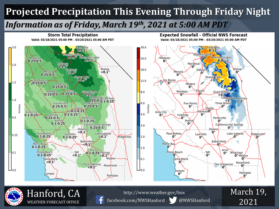
Projected rainfall totals for Mariposa: 1.00" to 1.50"
Projected rainfall totals for Oakhurst: 1.00" to 1.50"
Projected rainfall totals for Yosemite Valley: 1.00" to 1.50"
March 19, 2021 - The National Weather Service Hanford Office reports a storm system will continue to impact Central California through early Saturday morning.The majority of precipitation associated with this storm system will fall today (Friday).
Snow levels will start at around 8,000 feet this morning, before falling to about 5,000 feet this evening.
  Area Forecast Discussion
  National Weather Service Hanford CA
  329 AM PDT Fri Mar 19 2021


  .SYNOPSIS...
  A weather system will pass through Northern California through
  today. Precipitation associated with this system will trend
  lighter from northern areas to the southern locales in Central
  California. Temperatures will fall back to below seasonal values
  this weekend. Locally gusty winds are possible in Central
  California early next week. Otherwise, dry and warmer weather
  will return.

  &&

  .DISCUSSION...
  The north to south cold front has began to stall out and is
  becoming more of a stationary frontal system. Looking at current
  09z radar and satellite imagery the front is pivoting and will
  become more west to east orientated by late this evening. A
  majority of the CWA is in the warm side of the system with current
  snow levels now having risen to around 8000 feet. Very mild and
  breezy conditions have enveloped the San Joaquin Valley this early
  morning. Here at the Hanford Weather Office we are currently at
  57 degrees and temperatures across the area are running about 6 to
  9 degrees higher than 24 hours ago.

  As expected the majority of the precipitation has been occurring
  north of Kern County and so far very light precipitation has
  fallen in the San Joaquin Valley portions of the CWA. Current
  radar trends indicate most of the scattered precipitation has been
  falling from Fresno county northward and at this time only 0.02
  inches has been recorded in Merced, 0.01 inches at Fresno Air
  Terminal, and a Trace here at the office. Precipitation has been
  falling pretty steady over the Sierra Nevada near Yosemite.
  However, the snow levels this morning hovered around 6000 feet and
  are now about 2000 feet higher, so in many places where light
  snow was falling earlier yesterday is now in liquid form. Light
  scattered precipitation will continue to fall across the area from
  Tulare and Kings County northward through the rest of the day.

  As the west to east boundary begins to move southward late tonight
  and early Saturday Kern County will finally get into the action
  with light precipitation transitioning slowly southward through
  early Sunday morning keeping the threat of light showers over the
  area until then. Sunday, weak shortwave ridging will move into the
  region through Monday and a warming trend will ensue. The only
  caveat here is that another Pacific Northwest system is progged to
  move southward well inland (inside slider) into the Great Basin
  with strong Pacific ridging in place off the west coast. This will
  create a steep tightening of the gradients over California and
  will increase the northerly winds. At this time, the heights look
  to stay status quo and some downsloping into the SJV from a
  northeasterly vectoring of winds over the Sierra will keep
  temperatures slightly above normal levels. Keep in mind that the
  best laid plans of mice and men could be derailed if the trough
  moves further westward than anticipated.

  Stronger ridging is expected to move into the region on Wednesday
  and temperatures above 70 across the SJV and Kern desert areas
  would once again be on tap. Current probabilistic data suggests a
  89 percent chance of this being the case in Fresno and 78 percent
  in Bakersfield on Wednesday.
Source: NWS

